

KERMAN
i. Geography
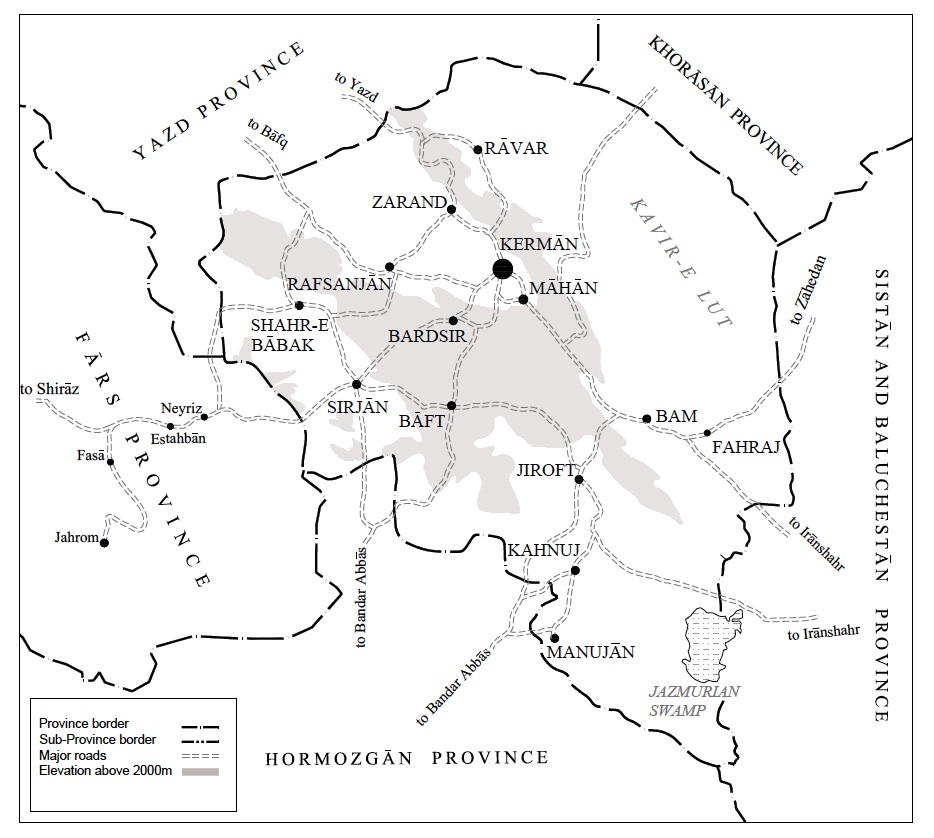
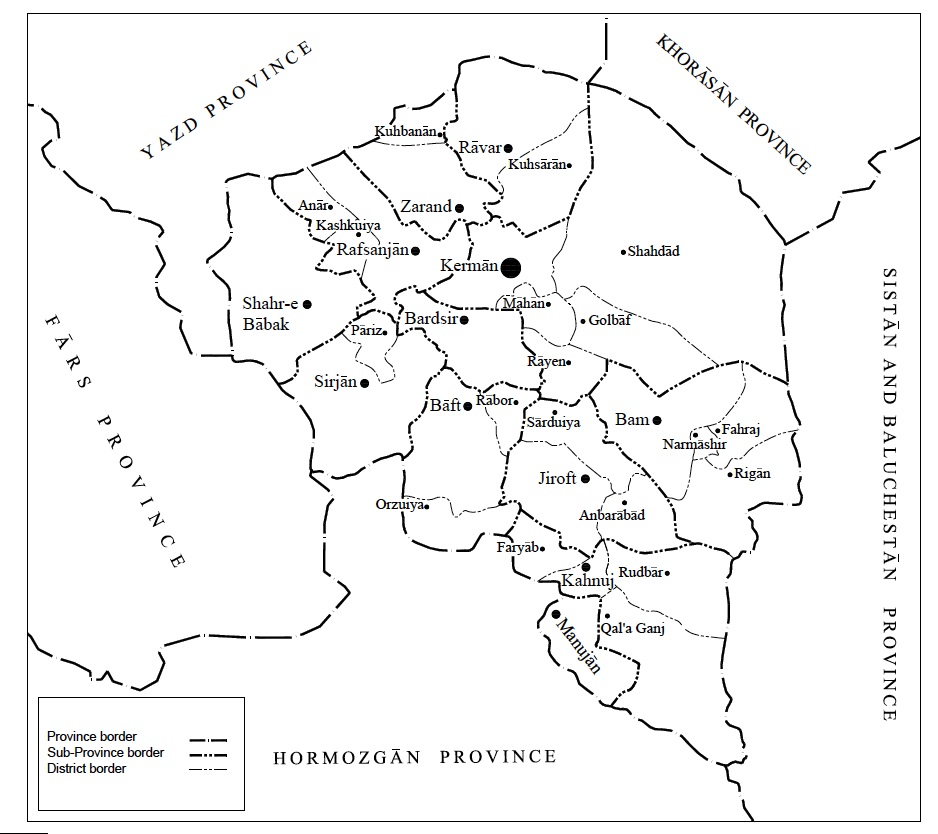
Physical geography. Kerman Province is situated in southeast Iran, to the southwest of the Kavir-e Lut (see DESERT). Covering an area of 182,000 km² (70,000 square miles), Kerman is the largest province in Persia, constituting 11 percent of its soil. The province lies between lat 26°29′ and 31°58′ N and long 54°20′ and 59°34′ E; it forms roughly an inverted right triangle facing west, with an east-west base of 470 km in the north and height of 630 km. The province is bounded in the southwest by Hormozgān and Fārs Provinces, in the northwest and north by Yazd Province, in the northeast by Khorasan Province, and in the east by Sistan and Baluchistan Province (Figure 1).
The physical features that delineate the province are primarily deserts. The Kavir-e Lut separates Kerman from historical Qohestān (now South Khorasan Province) and Sistān, while the southerly extension of the Kavir encircling the Jāz Muriān marsh (hāmun) is a barrier between Kerman and historical Makrān (present-day Baluchistan). In the west of the province there are patches of wasteland, most notably the Kavir-e Namak-e Sirjān, locally known as Kafa-ye Qaṭru (Abbott, p. 66), that form a natural boundary between the two provinces of Kerman and Fars. However, in the south the last stretches of the Zagros mountain chain provide some natural continuity between southern Kerman and Lārestān district in Fars.
Bordering the low-lying desert, the province’s north and center form a plateau typically 2,000 to 2,500 m in elevation (Figure 1), characterized by mountains that offer shelter to its settlements. The plateau includes a succession of mountain chains with a general pattern from northwest to southeast spanning the province. The northern range has the summits Ḵˇāja (2,175 m), Čehel Doḵtar (3,084 m), Lakar (2,965 m), Bāḡbālā (3,711 m), and Palvār (4,233 m). To its south runs a parallel, but much narrower, tangled ridge with angular crests and the summit Jupār (4,089 m) overlooking the city of Kerman. Further south, the massif in the center of the province is punctuated with the peaks Čehel Tan (3,765 m), Lālazār (4,234 m), Hazār (4,465 m), and Bahr Āsemān (3,046 m). It is in the foothills of these mountain chains that the upland oases of the province lie (topographic data obtained from online sources, especially satellite images at Google Earth).
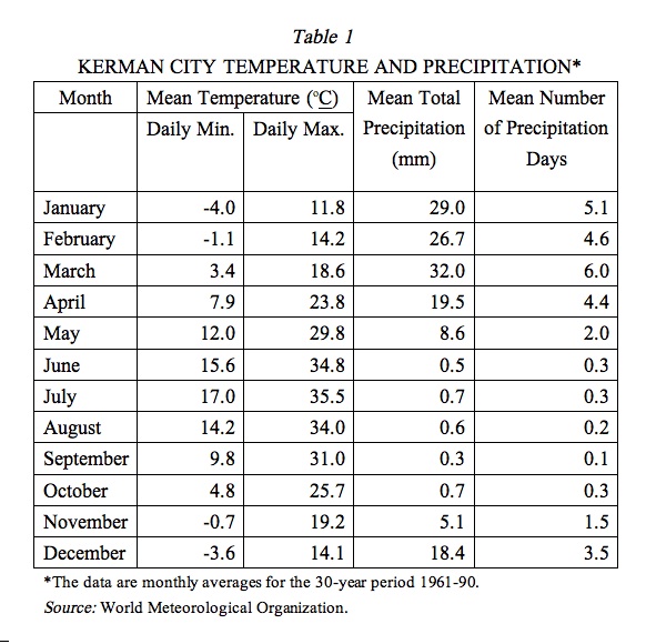
The province falls into the arid and semi-arid zones and like much of the Iranian plateau suffers from scarcity of water—a dire condition as the population continues to grow. There are several, but mostly seasonal, mountain streams. The only significant river is the Halilrud, about 400 km long, which is joined by its tributary, the Ābšur river (q.v.), near Jiroft. The Halilrud river irrigates the vast fertile plain of Jiroft and disappears further south into the marshes of the Jāz Muriān. The latter, originally a lake basin (cf. HĀMUN i), has been reduced to an essentially dry marshland since the Halilrud’s water was regulated, after construction of the Jiroft dam. The average annual rainfall is low and decreases towards the southeast, although the topography gives rise to many local variations. Maximum precipitation occurs in winter; the annual average rainfall is 80 mm and 142 mm in the cities of Bam and Kerman respectively (see Table 1 for details). But precipitation is more abundant at higher elevations, and the snow that falls in the mountains refills the aquifers from which manmade underground channels (qanāt, kāriz) draw water for irrigation, notwithstanding the brackishness of the qanāts’ outflow in many places. Most of the older subterranean watercourses have dried up, whether because the flow in the aquifers is entirely consumed or the underground water is sucked out by electric pumps; since the 1940s, the use of deep wells has become prevalent for creating islets of intensive cultivation (Beckett, 1953; English, pp. 30-38, 135-40; Spooner and Salzman, p. 112).
The binary climatic division of the Iranian Plateau into cold and warm zones (sardsir and garmsir; see CLIMATE) is quintessential in Kerman. The province is divided into two distinct macroclimates, sardsir in the upland north and garmsir in the lowland south, generally speaking. The upland Sirjān has a temperate climate, while Kerman, Rafsanjān, Zarand, and Rāvar have hot summers and mild winters. The southern districts of Bam, Jiroft, Kahnuj, and Manujān are characterized by having warm climate with an increasing humidity towards the Sea of Oman and the Indian Ocean. At the city of Kerman, with an elevation of 1,762 m, the average high temperature in January is 11.8° C, and the average low is -4.0° C. In July the average maximum and minimum are 35.5° C and 17° C, respectively. Put in a national perspective, with consideration of temperature and precipitation combined, the district of Kerman lies within a “steppe” climate, compared with the desert status of Yazd and Zāhedān and the humid status of Bandar ʿAbbās (cf. English, p. 8).
The province’s flora reflect its climatic dichotomy. The highlands contain traces of a dry forest of shrubs and trees such as pistachio and almond; the plains and accessible areas of the foothills have been deforested—the natural vegetation has been lost due to charcoal making and goat and sheep grazing (see FORESTS AND FORESTRY). Nevertheless, there still survive several wild species that are used as dyes in the carpet weaving industry of Kerman (English, p. 14). The lowlands are covered thinly with steppe-like flora, most notably species of lotus (konār), myrtle, oleander, tamarisk, and acacia (see FLORA). A clear-cut demarcation line between these two climatic zones reveals itself in agriculture. While in the upland districts temperate horticulture is the norm, citrus and date palm farming prevail in warm zones.
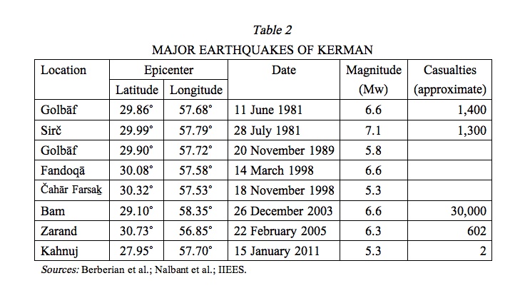
Despite the favorable condition the mountains provide for human settlement, they are also the cause of destructive earthquakes (see Afsari for historical earthquakes). Modern documentation (Table 2) reveals an average return period of five to ten years for significant seismic events. The highest seismic activity belongs to the fault system called Gowk along the longitudinal edge separating the Kerman plateau from Dašt-e Lut. It extends some 100 km approximately from Šahdād to Golbāf, traversing Čahār Farsaḵ, Sirč, Ābgarm, Jowšān, Fandoqā, Zamānābād, and Golbāf (Berberian et al.; Nalbant et al.). A shorter fault in the south, also running longitudinally, was responsible for the devastating Bam earthquake in December 2003; its destructiveness was not so much due to the earthquake’s (moderate) magnitude as it was to the poor quality of the physical infrastructure. With adobe as the chief construction material, the Bam citadel (Arg-e Bam) was susceptible to even moderate earthquakes and therefore could not have been a very old construction, given the short return-period of seismic events in the region.
Administrative boundaries and divisions. Although the geographical concept of Kerman in its narrow sense pertains chiefly to the cold highlands or the northern plateau that covers the current province, in a wider sense, at least in modern history, Kerman was one of the four eyālats or super-provinces (together with Azerbaijan, Khorasan, and Fars) that formed four quadrants over the map of Persia, an arrangement perpetuated by the law of territorial divisions of 1907 (Wadiʿi). In this setting, Kerman Province, also known as Kerman and Makrān or Kerman and Baluchistan, extended eastward up to the Indo-Persian border and southward to the Sea of Oman (Keyhān, II, pp. 244-57). The administrative reforms of 1934-38, which divided Persia into ten provinces, made little change in the borders of the former Kerman province, which was now called the Eighth Province (constituting Kerman, Bam, Bandar ʿAbbās, Ḵāš, and Zābol; see Wadiʿi). The territory of the Eighth Province shrank over the subsequent decades, to what is now called Kerman Province, due to two major secessions. The eastern half of the historical province was incorporated into the new province of Sistan and Baluchistan, and the southern coast was carved off to form what is known today as the province of Hormozgān.
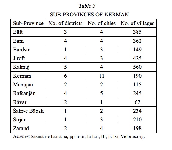
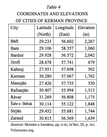
The administrative mosaic of the province has increasingly become finer over the decades. Kerman Province, within its present borders, began with five sub-provinces (Kerman, Bam, Jiroft, Sirjān, and Rafsanjān; Razmārā, 1953, pp. 430-31; cf. Sāzmān-e barnāma, 1970), and grew into a dozen in the 2000s (Table 3, Table 4, Figure 2). The number of districts within each sub-province has grown in a proportional manner. In spite of all these variations, the city of Kerman (1,038 km distance to Tehran) remains the most important provincial capital in the southeastern quarter of Iran.
Economy. Having economically ranked low among Iranian provinces and cities for most of the 20th century, Kerman became engaged in national economy through exploitation of its rich mines, expansion of transportation infrastructure, and establishment of educational and tourism services. Kerman City, although still the commercial center of the province, no longer monopolizes urban development: Rafsanjān has joined the competition thanks to political favoritism toward the Rafsanjāni clan, who have roots in the booming town of Rafsanjān.
Agriculture still plays an important role in the economy of Kerman Province. The upland regions have diversified subsistence farming of cereals, potatoes, cotton, sugar beets, oilseeds, vegetables, and a large variety of fruits, including peaches, cherries, apples, pears, persimmons, as well as nuts (English, pp. 117-20; WAP, II, pp. 951-54). Kermani cumin, mostly cultivated in Bāft, enjoys such a nationwide reputation that it has led to the proverb: zira ba Kermān bordan (lit. “carrying cumin to Kerman”), approximating the English phrase of “carrying coals to Newcastle.” Pistachios, another famous product of the province that is farmed in Rafsanjān, has in recent decades become subject to semi-mechanized agronomy and is produced in such a large quantity that it is exported abroad after saturating national markets. Production of another labor-intensive crop, sugarcane, is rapidly expanding, especially in Bardsir (Razavi). Poppy farming was an important cash crop for Kermani farmers, but, ever since its ban in the mid-20th century (see AFYUN), the high amount of opium consumed in the province is smuggled from Afghanistan. In the warm lowlands of the province, rice, cereals, fruits, and henna are grown. The agriculture of Bam has come to be dominated by date palm and citrus farming, the produce of which is marketed throughout Iran (Sāzmān-e barnāma, 1970). Banana cultivation had been introduced in the garmsir regions by the turn of the century.
Animal husbandry has lost its edge in the province. Tending large flocks of sheep and goat was partly an occupation of various nomadic groups throughout the province (Razmārā, 1944, pp. 144-53), including the Afšārs who wintered in Jiroft and summered in Bāft (see ʿAŠĀYER). They produced wool, including down wool (kork), which was used in weaving the famous shawls of Kerman. Erosion of the traditional nomadic and rural base and destruction of the grassland through overgrazing has resulted in a sharp decline in animal herding, while mechanical raising of livestock has gained very little success (English, pp. 107-8; WAP, p. 954).
Kerman has long excelled in manufacturing textile and weaving carpets. The Kerman carpet is as famous as its cumin and is the subject of a Persian metaphor meṯl-e qāli-e Kermān (“like a Kerman carpet”), implying the idiomatic expression “the older, the better.” Carpet manufacture remains one of the main industries of Kerman city and its neighboring districts, although its international market is far less promising than it used to be (see CARPETS vii. PAHLAVI PERIOD). Hand-woven carpets have increasingly given way to the much cheaper machine-made rugs, which are produced in large factories. There were also many textile factories that produced Kerman’s famous shawls, brocade (terma; see CLOTHING xxvii), and ʿabāʾ, but these are no longer flourishing, while pata-duzi, an embroidering art (see CRAFTS), still survives as a cottage industry (WAP, p. 957).
Since Kerman sank to a city of second rank for most of the 20th century, other manufacturing sectors were not highly developed there. Modern industries of some significance are the construction industry, producing cement and brick; sugar refining; and the food industry—all producing for local consumption (WAP, p. 958; Wezārat-e defāʿ, pp. 31-32). Heavy industry has little presence in the province at the present time. In the 1960s, in a project to develop a national steel mill, Kerman province was considered as a site because of its iron ore and coal mines, but insufficient water sources in Kerman made Isfahan (see ISFAHAN xiv. MODERN ECONOMY AND INDUSTRIES) the choice candidate, to which Kerman’s coal and iron ore are now shipped.
No business engages Kerman with the national networks to a greater extent than mining does. Extensive mining of coal, iron ore, and copper is being carried on in various parts of the province. Coal deposits extend in the mountains from Zarand to Rāvar, yielding most of national coal consumption in Iran; the mines are operated chiefly by Iran National Steel Mill Corporation (see also COAL). The iron ore deposits of Gol Gowhar in Sirjān sub-province are one of largest worldwide. The mined ore is pelletized in a local plant, yielding up to five million tons of iron ore annually (see STEEL INDUSTRY IN IRAN). Copper deposits of Kerman Province extend along a beltline from Šahr-e Bābak southeastwardly (see COPPER ii). The richest copper mine, one of the largest in the world, is at Sarčašma, located 50 km south of the city of Rafsanjān. Systematic mining operations were begun in 1972 by the Sarčašma Copper Company, operated since 1976 under the auspices of the National Iranian Copper Industries Co. The company’s prosperity is evident from the presence of its football team, Ṣanʿat-e mes-e Kermān, in the national league, as well as the construction of a stadium with a capacity for 35,000 fans (NICIC). All these mining operations in Kerman Province are supported by a gas pipeline from Bandar ʿAbbās to Kerman and a network of electricity transmission lines.
The service sector has been growing rapidly in the province, especially in higher educational infrastructure, which has seen an enormous growth since the establishment of the Rāzi Nursing School (1962) and the Institute of Technology (1969). The reemergence of Kerman on the national stage was sought through the founding of a full university in the 1970s. At present, the University of Kerman and Kerman University of Medical Sciences, both in the city of Kerman, rank among national universities; Rafsanjān, too, has its own general and medical universities established during the administration of ʿAli-Akbar Hāšemi Rafsanjāni (president of Iran, 1989-97). Additionally, the Islamic Āzād University has a range of campuses (see EDUCATION xviii. HIGHER EDUCATION), operating in sub-provincial capitals at Kerman, Bāft, Zarand, Jiroft, Bam, Bardsir, and Kahnuj. These institutions attract a large number of students from all over the country, with symbiotic effects that used to be entirely unknown in the province. Moreover, tourism has been on a sharp rise thanks to promotion of the province’s architectural attractions. These include the Safavid-period complexes built by Ganj-ʿAli Khan (q.v.) and by Wakil, and the Zoroastrian fire temples, in Kerman City; Shah Neʿmatallāh’s mausoleum and Bāḡ-e Šāhzāda in Māhān; the renowned fort of Bam (q.v.); and the prehistoric excavations in Jiroft (q.v.).
Modern transportation infrastructure has been the most essential means in bringing Kerman out of its historical isolation caused by deserts and mountains. In addition to the grid of modern highways that connect urban centers within and without the province, the Yazd-Kerman line of the trans-Iranian railway extends as far south as the city of Kerman and is anticipated to reach Zāhedān in future. Another railway branch from Yazd, to Bafq and Bandar ʿAbbās, bypasses Kerman City but cuts across the western parts of the province to reach the copper mines of Sarčašma and iron ore mines of Gol Gowhar. The railroad also gave rise to the idea of a Sirjān Free Trade Zone, designed to become a nodal point on a commercial transit grid between the southern seaport terminals and the inner plateau. Last but not least is air transport, in which Kermani businessmen made a surprising initiative in 1992 by establishing Mahan Airline, which has grown to one of the largest airline companies in the country.
See also: Bāfq, Bārez, Bašākerd, Beh-Ardašir, Dārzin.
Bibliography (online sources accessed 28 October 2013):
Keith Edward Abbott, “Geographical Notes Taken during a Journey in Persia in 1849 and 1850,” JRGS 25, 1855, pp. 1-78.
Reżā Afsari, “Zelzelahā-ye Kermān wa wabā-ye sardār,” Waḥid, serial nos. 219-20, 1977, pp. 69-78.
Philip H. T. Beckett, “Qanats around Kerman,” Journal of the Royal Central Asian Society 40, 1953, pp. 47-57.
Idem, “Agriculture in Central Persia,” Tropical Agriculture 34, 1957, pp. 9-28.
Idem, “The Soils of Kerman, South Persia,” Journal of Soil Science 9, 1958, pp. 20-32.
Philip H. T. Beckett and E. D. Gordon, “Land Use and Settlement Round Kerman in Southern Iran,” The Geographical Journal 132/4, 1966, pp. 476-90.
M. Berberian et al., “The 1998 March 14 Fandoqa Earthquake (Mw 6.6) in Kerman Province, Southeast Iran: Re-rupture of the 1981 Sirch Earthquake Fault, Triggering of Slip on Adjacent Thrusts and the Active Tectonics of the Gowk Fault Zone,” Geophysical Journal International 146/2, 2001 pp. 371-98.
Michael E. Bonine, “The Morphogenesis of Iranian Cities,” Annals of the Association of American Geographers 69/2, 1979, pp. 208-24.
Mohammad Dastanpour, “The Devonian Stratigraphy of Kerman, Southeast Central Iran,” Ph.D. diss., University of Bristol, 1990.
Paul Ward English, City and Village in Iran: Settlement and Economy in the Kirman Basin, Madison, 1966.
Gitā-šenasi Cartographic Institute, Aṭlas-e rāhhā-ye Irān, Tehran, 2007.
Google Earth, at http://www.google.com/earth/index.html; consulted 21 May 2013.
ʿAbbās Jaʿfari, Gitā-šenāsi-e Irān II: rudhā wa rud-nāmahā-ye Irān, Tehran, 1997.
ʿAbd-al-Rafiʿ Ḥaqiqat “Rafiʿ,” Farhang-e tāriḵi o joghrāfiāʾi-e šahrestānhā-ye Irān, Tehran, 1997, pp. 438-39.
[IIEES] International Institute of Seismology and Earthquake Engineering, at www.iiees.ac.ir.
Masʿud Keyhān, Joḡrāfiā-ye mofaṣṣal-e Irān, 3 vols., Tehran, 1931-32.
Anne K. S. Lambton, “Kirmān,” in EI2 V, 1986, pp. 147-66.
Guy Le Strange, “The Cities of Kirman,” JRAS, 1901, pp. 281-90.
Laurence Lockhart, Persian Cities, London, 1960.
John Gordon Lorimer, Gazetteer of the Persian Gulf, Omān and Central Arabia, Calcutta, 1908; repr. two parts in 6 vols., II: Geographical and Statistical, Westmead, UK, 1970.
Ḡolām-Ḥosayn Moṣāḥab, Dāyerat al-maʿāref-e fārsi, 2 vols., Tehran, 1966-77, II, pp. 2251-52.
Soleyman S. Nalbant, Sandy Steacy, and John McCloskey, “Stress Transfer Relations among the Earthquakes that Occurred in Kerman Province, Southern Iran Since 1981,” Geophysical Journal International 167/1, 2006, pp. 309-18.
[NICIC] National Iranian Copper Industries Co., at www.nicico.com.
Shahrashoub Razavi, “Agrarian Change in Two Regions of Kerman,” Iran 29, 1991, pp. 161-79.
Ḥosayn-ʿAli Razmārā, Joḡrāfiā-ye neẓāmi-e Kermān, Tehran, 1944.
Idem, ed., Farhang-e joḡrāfiāʾi-e Irān VIII: Ostān-e Haštom, Kermān o Makrān, Tehran, 1953.
Sāzmān-e barnāma wa budja, Markaz-e āmār-e Irān, Village Gazetteer: Farhang-e ābādihā-ye kešvar XX–XXI: Ostān-e Kermān, Tehran, 1970.
Idem, Sar-šomāri-e ʿomumi-e nofus o maskan: ostān-e Kermān, Tehran, various years.
Idem, Sar-šomāri-e ʿomumi-e kešāvarzi 1367: farhang-e rustāʾi, Tehran, 1991.
Sāzmān-e fār, Rāhnemā-ye šahrestānhā-ye Irān: barā-ye mohandesin-e mošāwer ..., ed. Ebrāhim Eṣlāh ʿArabāni, Tehran, 1967.
Brian Spooner and Philip C. Salzman, “Kirman and the Middle East: Paul Ward English’s City and Village in Iran: Settlement and Economy in the Kirman Basin,” Iran 7, 1969, pp. 107-13.
L. E. Stockwell, World Mineral Statistics 1993-97: Production, Exports, Imports, Keyworth, UK, 1999.
Kāẓem Wadiʿi, “Edāra wa taqsimāt-e kešvar-e Irān,” Barrasihā-ye tāriḵi 4/2-3, 1969, pp. 233-54.
Aḥmad-ʿAli Waziri Kermāni, Joḡrāfiā-ye mamlakat-e Kermān, ed. Moḥammad-Ebrāhim Bāstāni Pārizi, in FIZ 14/1-4, 1966-67, pp. 5-286.
[WAP] Wezārat-e āmuzeš o parvareš, Joḡrāfiā-ye kāmel-e Irān, ed. ʿAbd-al-Reżā Faraji et al., 2 vols., Tehran, 1987, II, pp. 922-63.
Velorouts.org, at http://veloroutes.org/elevation.
Wezārat-e defāʿ o poštibāni-e niruhā-ye mosallaḥ, Sāzmān-e joḡrāfiāʾi, farhang-e joḡrāfiāʾi-e ābādihā-ye ostān-e Kermān: šahrestān-e Kermān, Tehran, 2003.
World Meteorological Organization, “Kerman: Iran, Islamic Republic of,” at http://worldweather.wmo.int/en/country.html?countryCode=IRN (select: Kerman).
(Habib Borjian)
Originally Published: August 19, 2014
Last Updated: September 8, 2015
Cite this entry:Habib Borjian, “KERMAN i. Geography [2014],” Encyclopædia Iranica, online edition, 2014, available at http://www.iranicaonline.org/articles/kerman-01-geography-archived (accessed on 30 December 2014).