

ISFAHAN
ii. HISTORICAL GEOGRAPHY: AN OVERVIEW SINCE ANCIENT TIMES
The Isfahan oasis, as a prosperous area of agricultural life, eventually fostered the foundation of a major city—one whose strategic location helped it to dominate the entire area of Iran. At a latitude approximately in the middle of Iran, Isfahan is at the maximum degree of east longitude where communications are still easily manageable between the northern and southern parts of the country. Heading north, one reaches—with a slight deviation to the west—the foothills of the Alborz (q.v.) and Tehran, traveling west of the Great Kavir via Qom and several minor basins with infrequent desert stretches. Towards the south, low passes give access to Fars. Westwards, one quickly reaches the most densely populated areas of the Zagros, with extensive dry-farming and heavy rainfall, for which Isfahan is the primary base for controlling tribes, especially, in the modern era, the powerful Baḵtiāri (q.v.) confederation. To the southeast, a long depression within the mountains, nowadays followed by the railroad, easily leads to the large cities of Yazd and Kerman, which mark the main rim of the Zagros.
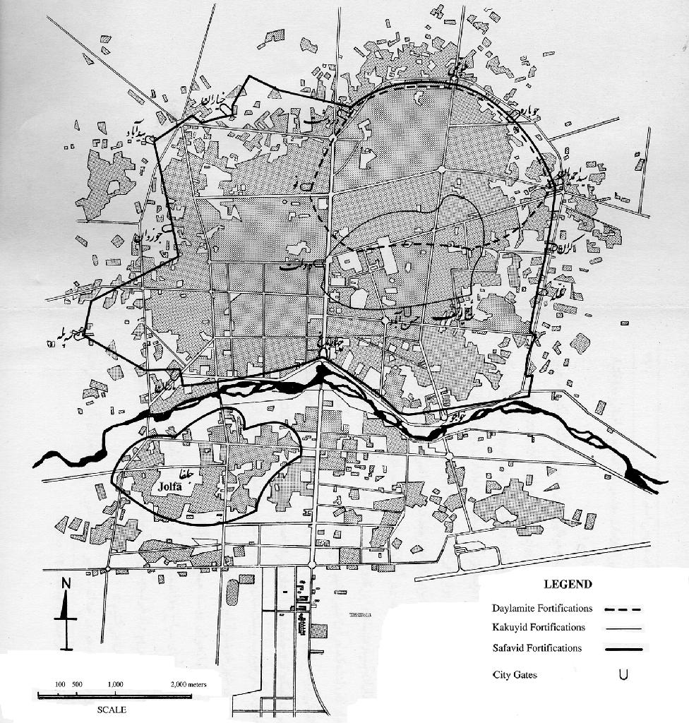
Figure 1. Historical map of Isfahan with its fortifications under the Buyids, Kakuyids, and Safavids.
Iranian capital or provincial headquarters? The name of the city of Isfahan from very early on evokes this notion of centrality. One finds it in Ptolemy (Geographia 6.4.4) as Aspadana, meaning “place of gathering for the army” (Spiegel, I, p. 100; see discussion below, iv). But for this positive geographical location to be fully exploited, favorable political conditions were required. Two conditions had to be met. First, from a strictly geographical point of view, the country had to be unified so that the city would be placed approximately at the center of the land it was to govern, thus optimizing conditions for rule. Second, from a strategic standpoint, external threats to this state had to be deflected equally from all surrounding areas, or else be negligible and not require constant intervention in one direction. In the latter case the country’s capital would tend to be placed at the periphery, near the main source of potential danger. For Isfahan to become the capital of Iran, then, it was necessary that the country be delimited more or less as it is at present and that it be powerful and confident of its might, indifferent to relatively weak external threats. These two conditions were only met occasionally during the country’s history.
This was clearly not the case during the first two millennia of political existence. When the first political organization emerged among Iranian tribes with the advent of the Median empire, unification of the tribes was far from being achieved. The center of power could obviously only be located at the core of the area under immediate control (see ECBATANA). When the Persians rapidly built the powerful Achaemenid empire from Fars, their historical home, it soon extended beyond Iranian lands by conquering the Fertile Crescent. For an empire that was to succeed the Assyro-Babylonian, the political seat (Susa) was most naturally located in Mesopotamia, which was endowed with an already glorious urban tradition—this to the detriment of the former center in Persepolis. From Mesopotamia the empire looked, in the main, to expand westward, to Egypt and Anatolia. After Alexander’s conquest, the Seleucids, who considered Iran and Mesopotamia as part of their heritage, and whose preoccupation was Greece, naturally maintained this tradition (Seleucia). When a specifically Iranian power re-emerged with the advent of the Parthians (see ARSACIDS), followed by the Sasanids, the clash in the west with the Roman empire continued to require situating the main center in Mesopotamia (see CTESIPHON). By integrating Iran into the vast caliphate territory under the Omayyads and early ʿAbbasids (with their capitals at Damascus and Baghdad), the Islamic conquest could not provide an opportunity to change the status quo.
During this entire period, Isfahan’s location could only serve as a provincial city. Yet, under various names and in successive sites, not easy to follow precisely, it seems to have preserved some importance. Over the centuries, the surrounding province retained its original name (i.e., Aspahan, a division of the Sasanid empire, in Moses of Khorene: Markwart, Eranšahr, pp. 28-29; see below, iv), while names of cities, even peoples, were superimposed on the city. During Alexander’s expedition, the name was Gabai (see GABAE)/Tabai (Ptolemy, Geog. 4.4.7), an important locality having an Achaemenid royal residence (basileion, Strabo, 15.3.3; Quintus Curtius, 5.13.2; Polybius, 31.9.3). It was the capital for the Gabioi people (Ptolemy, Geog. 6.4.3), whose territory, extending beyond the surrounding mountains to “above the +Khuzis” [i.e., Khuzistani people] (huper de tous Souzaious), clearly went beyond the geographical limits of the oasis. However, this capital was obviously the core of the Gabian area, considered a wealthy region where armies could obtain fresh supplies (Diodorus, 19.26.2; Briant, pp. 757-58). This is the name that appears in many texts by Muslim geographers, who for the first time provide a detailed picture of the country, under an Arabicized form, Jay (maintained in the present district name Jey; see i [2] above). During the period following the Arab conquest, Jay was one of two neighboring, but very distinct, cities near Isfahan. The other, some 3 km west, was inhabited in part by a Jewish community and is named Yahudiya by Arab geographers (see below, iv and vi).
When exactly were these cities established and how did they become neighbors? It is very difficult to answer this question, since records preserved by medieval geographers are contradictory and differ mainly on this very point of dating the foundation of these cities (Schwarz, V, pp. 587-90, gathers all the references but does not draw any conclusions). For Jay, if one were to eliminate the strictly legendary accounts referring to figures from the Iranian epic as its founders, most authors (Ebn al-Faqih, Ṭabari, Qodama, Ḥamza) attribute the construction of the city and its protective walls to Alexander. Demašqi alone (ed. Mehren, pp. 278-79; tr., p. 405) attributes it to the Sasanian king “Firuz Yazdejerd,” that is, Pērōz (r. 459-484); this however, seems incompatible with information about Yahudiya (see below). Moreover, the texts cited above on the existence of Gabai during Alexander’s time, seem to indicate that a city already existed on the site and that the conqueror’s contribution, if any, was limited to reinforcement and perhaps reorganization of the urban layout. As for Yahudiya, the issue is even more obscure. Only one date seems sure. The city undoubtedly existed before 430 C.E., when Isfahan is noted as the seat of a Christian bishopric (Guidi, p. 396.15; Markwart, Eran-šahr, p. 30). As is known, the first Christian establishments in Iran were directly linked to the presence of Jewish settlements (Schwarz, V, p. 590); this excludes the possibility that Pērōz founded Jay. As for the ultimate origin of Yahudiya, an often-repeated tradition attributes it to the exodus of the Jews from Jerusalem after the destruction of Nebuchadnezzar II (587 B.C.E.; Demašqi; Ebn al-Faqih; Moqaddasi; Mostawfi). This is far from being proven, since all the ancient Jewish settlements tended to attribute their origin to this first exodus; and the Arab authors only repeated what was told to them. If accepted, this claim would be of interest in that it would set a date ante quem for the existence of Gabai (Jay), which seems to have indisputably antedated Yahudiya. The earliest Arab geographers, while recognizing both cities, always tended to consider Jay as the main city, “Isfahan” par excellence (references in Schwarz, V, p. 586). Moreover, it would be difficult to accept the idea of the foundation ex nihilo by the Jews of a new town that had not been a suburb of a pre-existing city.
Whatever the case may be, the twin cities, with their land, wealth, and favorable geographical site, attracted the Muslim conquerors’ attention. Arab geographers do not restrain their praise (texts in Schwarz, V, pp. 592-605), going as far as calling this land “a paradise” (Moqaddasi) or “a second Baghdad” (Ebn al-Faqih). However, for the reasons outlined above, it was not possible for the conquerors to make it the capital of Iran, then part of the caliphate. At the end of the Buyid period, although Isfahan became the headquarters of a quasi-independent emirate, the main political center always remained in Ray, near the Buyids’ original region in Deylam (see vi, below).
With the emergence of the Saljuqids, for the first time geopolitical conditions aligned to make Isfahan the capital of a state which, while still formally attached to the caliphs in Baghdad, henceforth exercised full political autonomy (with the title of Sultan given to its leaders) and whose center of gravity was increasingly upon the Iranian plateau. For almost a century, the Saljuqid empire around the “Great Saljuqs” was, strictly speaking, a constellation of Turkish principalities, more or less independent from the main branch, in Anatolia, Syria (Damascus and Aleppo), Iraq, Kermān, and Ḵʷārazm, while the Ghaznavids further southeast were reduced to a state of tributaries. Those emirates on the periphery were faced with external conflicts, but the central dynasty enjoyed a relative calm only disturbed by occasional disputes over succession. Isfahan’s central location facilitated satisfactory control of relations with the more or less vassal states, and at least nominal coordination of the whole empire. It is therefore no surprise that the city was chosen by Ṭoḡrel Beg, who in 442/1050 transported from Ray “all that he possessed in gold, provisions, and arms, to make it his permanent residence” (Ebn al-Aṯir, IX, pp. 17, 234,).
Isfahan lost its central role with the disintegration of the empire of the Great Saljuqs upon the death of Sanjar (552/1157) and under the subsequent rule of the Mongols, who established their Iranian headquarters in the north (Azarbaijan, subsequently Solṭāniya). After the long period of political division that followed, it was only under the Safavids that Iran, until then disputed between the Timurids and the Āq Qoyunlu (q.v.), acquired the territorial unity required for a national capital. This did not occur until the end of the 16th century, since the constant wars between the Safavids and the Ottomans during the entire first half of the century required the location of authority at this time first in Azarbaijan, then in Qazvin. In 1006/1598 Shah ʿAbbās I chose Isfahan as a central capital for his empire, which was now established approximately within the present borders of Iran. Factors in his selection included the stabilization of the western border of the empire after the peace of Amasya (962/1555, q.v.), the growing Uzbek menace on the northeast, and the European presence in the Persian Gulf that required a watchful eye on the southern shores. Isfahan remained the capital until its destruction by the Afghans in 1135/1722 (see AŠRAF ḠILZAY). The city was never to have such a status again, since changing strategic considerations to deal with the emerging Russian and Turkmen menace drove the Qajar dynasty at the end of the 18th century to select Tehran (q.v. at iranica.com).
Structure and development of the metropolitan complex. The magnificent urban landscape that has made Isfahan the gem of architecture in Iran and an everlasting witness to its culture thus was formed in the course of two limited periods, one approximately a century, another a century and a quarter.
The guiding principle for the urban evolution of the city was the advance toward the river. The twin cities were established some 3 km north of the river, perhaps due to fear of flooding; this was still a concern at a time when the development of irrigation channels within the oasis was not of sufficient scale for their diversion of water from the river to almost completely mitigate this danger. As development of the oasis progressed, natural evolution brought the settlement area nearer the river, for practical purposes (water for domestic consumption and artisanal use, the latter still present today when Baḵtiāri carpets are washed in the river during the season of low water) as well as for recreational and aesthetic reasons. This process has continued up to the modern period.
The point of departure for this development was Yahudiya, which had mostly supplanted Jay during the early Islamic period. All the information from Arab geographers indicates that the relative decline of Jay was early. There were signs of it in the tenth century in the account of Eṣ-ṭaḵri (pp. 182.5, 199.6), according to whom Jay already was no more than half the size of its twin, and it is confirmed by Moqaddasi (p. 225.6). The revision of Eṣṭaḵri’s text in the Gotha manuscript, perhaps of the same period, indicates that all commercial activity was centralized in Yahudiya (p. 199, note a; Schwarz, V, p. 604). This state of affairs may be a consequence of specialization in trade by the Jewish population, which had profited substantially from the Muslim conquest. Jay gradually fell into ruins, as Yāqut already noticed (III, p. 196; VIII, p. 532).
This may explain why Ṭoḡrel constructed his still standing Great Friday Mosque in Yahudiya, most probably on a pre-existing mosque site, and also why he set up another essential feature of power south of the bazaar and facing south, namely the large square for military parades and exercises (Meydān-e kohna) whose location can still be made out today (Gaube, pp. 231-32). There he also had a circular enclosure constructed (ibid., p. 46), inspired by the concept of a “round city” known in Muslim urban planning since the foundation of Baghdad. Given the surface area (approx. 1.7 km2) within the wall, the population of the city could have amounted to tens of thousands of residents. Activity in the bazaar, as witnessed by Nāṣer Ḵosrow in the mid-11th century, was then quite considerable. At that date, a distinctly centralized hierarchy incorporating both wholesale (caravansaries) and retail trade is to be emphasized, as it points to the oldest instance of the classical structure of a central bazaar in the Muslim world (Planhol, 1987).
Orientation toward the south and the river, already evident during the Saljuqid period, became more pronounced later on. In this direction, linked to pre-existing construction by a new bazaar, whose monumental entrance led to Shah ʿAbbās’s large new square for parades, the grandiose Safavid urban design was put on display, with the wide Čāhār Bāg avenue leading to the Zāyandarud as its showpiece. Many monumental bridges were then built: Allāhverdi Khan bridge, Ḵᵛāju bridge and dam, and Canal bridge (Pol-e čubi) were added to the older Šahrestān bridge, whose location further east had been established according to the location of Jay. The city next extended across the river, where the well-off built many residences, and where a significant Armenian settlement established a neighborhood in Julfa (q.v.)—an area with quasi-autonomous status and many tens of thousand residents. The Iranian metropolis thus became a huge city, whose population, though impossible to ascertain exactly, must have attained many hundreds of thousands at the minimum, based on descriptions of travelers and European residents (e.g., Herbert and Chardin, qq.v.), with a large number of foreigners settled near the bazaar (estimates summarized and discussed in Brown). The city spread out in all directions, not only south of the river, but also westward, where foreign traders established a neighborhood in close proximity to the bazaar, and east towards the former Jay and well beyond. This is illustrated by the fact that a traveler in the 19th century, arriving in Isfahan from the east, passed earth houses in ruins along 16 to 18 kilometers before reaching the city (Floyer, p. 367).
Isfahan in contemporary Iran: from decline to renewal. After the end of the Safavid dynasty, indeed from 1722, the city suffered terribly. Following the Afghan invasion and subsequent massacres, it was pillaged on two more occasions, after Nāder Shah’s assassination, by Baḵtiāri and other Lor rebels. In the 1810s a British visitor writes that, “ . . . one might suppose that God’s curse has extended over parts of the city, as it did over Babylon. Houses, bazaars, mosques, palaces, whole streets are to be seen in total abandonment; and I have rode for miles among its ruins without meeting with any living creature, except perhaps a jackal peeping over a wall, or a fox running to his hole” (Morier, p. 134). In the 1860s a permanent European resident of the country can only speak of the “ruins of Isfahan” and describes its former leisure gardens as having been transformed into wheat fields (Polak, I, pp. 95, 100). In 1890, a British lady traveling from the north, when crossing the city, sees “heaps of ruins” and complains that “ . . . that mile or more of Isfahan was the one disagreeable part of the journey” (Bishop, I, p. 244), until only in Julfa (then approximately 3,000 residents, including a European community in the midst of Armenians) does she find a pleasant environment with well-maintained gardens (ibid., p. 244). As late as 1900, Pierre Loti, who discovers a busy bazaar and luxurious gardens, speaks of “oppressive ruins” (p. 163).
Actually, it was only in the 1920s that the renaissance of the city really began, the main driving force being industrialization. The abundant water supply and the central location of the city in Iran then re-emerged as determining factors. The first phase centered on the textile industry. In the early 1920s a pioneering company (“Waṭan,” later re-christened “Mihan”) established itself there with state support, which was vigorously reinforced after 1925 under Reza Shah’s impulse (see INDUSTRIALIZATION ii; TEXTILE INDUSTRY at iranica.com). The textile industry remained almost the only area of industrialization there until the 1960s; at that time it employed some 15,000 individuals (18,000 in 1972), that is, about 30 percent of the entire country’s textile workers (see xiv, below). Up to that time the share of ownership by private capital had gradually increased.
The second phase occurred in the development of the steel industry (q.v. at iranica.com). The location, in the vast “Aryāmehr” complex some 25 kilometers southwest of the city center, on the foothills of the left bank of the Zāyandarud, spoke volumes in its favor. This state-sponsored heavy industry, constructed with Soviet assistance, was set up near Isfahan at great distance from the source for raw materials located hundreds of kilometers away in the coal basin north of Kerman and in the iron ore mines of the Bāfq region, between Kerman and Yazd. Factors in the selection of Isfahan included a substantial water supply, relatively easy provision of energy by pipeline from the oil-producing provinces in the Gulf, and the concentration there of skilled labor already trained for industrial work. The site first proposed in the late 1960s, at Čamzaman on the Trans-Iranian railway system, although not far from the iron deposits in Šamsābād, was rejected (Korby, pp. 92-93). Steel production began in 1973 with a workforce of 7,000 and a capacity of 600,000 tons, which was pushed upward to 4 million tons in the 1980s. Around these main plants, a diversified industrial landscape (with an oil refinery, sugar refinery, and other consumption industries) gradually coalesced, placing Isfahan second only to Tehran in industrial output. The main industrial area was established south of the residential area, along the banks of the Zāyandarud (see xiv, below).
Linked to this economic development, the population has been regularly growing since the 1920s. While it certainly did not exceed 50,000 residents in the early 20th century, it neared 100,000 in the 1930s, 254,000 according to the census in 1956, then 661,000 in 1976 and 1,266,000 in 1996. This growth can be explained mostly by high immigration, mainly from the mountainous regions of the western Zagros, near the city, as well as from Khuzestan since the Iran-Iraq War (see map of migratory influx in Hourcade, p. 53). To the city itself, one should add the numerous communities of the broader oasis that now form satellite cities, most notably Ḵomeyni-šahr (formerly Homāyun-šahr) with 165,000 inhabitants, and Najafābād numbering 178,000 inhabitants in 1996. In total, the city and oasis now well exceed 2 million residents, and Isfahan is thus clearly the second largest urban center in the country (see iii [2] and iii [3]).
Bibliography
Ali. Bakhtiar, “The Royal Bazar of Isfahan,” Iranian Studies 7/1-2, 1974, pp. 320-47.
Mirza Bala, “Isfahan,” in IṟA V/2, 1950, pp. 1068-72.
Elizabeth Beazley, “The Pigeon Towers of Isfahan,” Iran 4, 1966, pp. 105-9.
Pierre Briant, Histoire de l’Empire Perse. De Cyrus à Alexandre, Paris, 1996.
Mrs. Bishop, Journeys in Persia and Kurdistan, 2 vols., London, 1891.
Wilfrid Blunt and W. Swaan, Isfahan, Pearl of Persia, London, 1966.
J. Brown, “A Geographical Study of the Evolution of the Cities of Tehran and Isfahan,” unpubl. Ph.D. thesis, Durham, 1965.
Jean-Claude Cordonnier, “Les tendances nouvelles de l’agriculture irriguée dans l’oasis d’Isfahan,” Revue Géographique de l’Est 4, 1964, pp. 387-92.
Sherban Cantacuzino and Kenneth Browne, “Isfahan,” Architectural Review 150/951, 1976, pp. 253-322.
Jean Chardin, Voyages en Perse et autres Lieux de l’Orient, 10 vols., ed. and annot. L. Langlès, Paris, 1811.
V. F. Costello, Kashan: A City and Region of Iran, London and New York, 1976.
Šams-al-Din al-Demašqi, Noḵbat al-dahr fi ʿajāʾeb al-barr wa’l-baḥr, ed. M. A. F. Mehren as Cosmographie de Chems-ed-din Abdallah Mohammed ed-Dimichqui, Saint-Pétersbourg, 1866; repr., Leipzig, 1923; tr. Mehren as Manuel de la cosmographie du Moyen Age, Copenhagen, 1874.
Ebn al-Athir, al-Kāmel fi’l-taʾriḵ, ed. C. J. Tornberg, 13 vols., Beirut, 1966.
Ebn al-Faqih, Moḵtaṣar Ketāb al-boldān, ed. M. J. de Goeje, Leiden, 1967, pp. 261-63.
Eckart Ehlers, “Capitals and Spatial Organization in Iran: Esfahan, Shiraz, Tehran,” in Chahryar Adle and Bernard Hourcade, ed., Téhéran capitale bicentenaire, Bibliothèque Iranienne 37, Paris and Tehran, 1992, pp. 155-72.
Paridokht Fesharaki, L’oasis d’Isfahan. Thèse inédite de Doctorat en Géographie, Université de Paris-Sorbonne, 1967.
Ernest Ayscoghs Floyer, Unexplored Baluchistan, London, 1882.
Food and Agricultural Organization of the United Nations, Islamic Republic of Iran, FAO Agriculture Series No. 31, Rome 1998; online at http://www.irvl.net/food-Iran.htm. Heinz Gaube, Iranian Cities, New York, 1979.
Idem and Eugen Wirth, Der Basar von Isfahan, Wiesbaden, 1976.
Lisa Golombek, “Urban Patterns in Pre-Safavid Isfahan,” Iranian Studies 7/1-2, 1974, pp. 18-48.
J. Guidi, “Ostsyrische Bischöfe und Bischofssitze im V., VI. und VII. Jahrhundert,” ZDMG 43, 1889, pp. 388-414.
Thomas Herbert, Travels in Persia, ed., William Foster, London, 1928.
Renata Holod, ed., Studies on Isfahan, special issues of Iranian Studies 7/1-2 and 7/3-4, 1974.
Bernard Hourcade et. al., Atlas de l’Iran, Montpellier-Paris, 1998.
Hans Knübel, “Das erste Eisenhüttenwerk im Iran bei Isfahan,” Geographische Rundschau 23, 1971, pp. 368-70.
Wilfried Korby, Probleme der industriellen Entwicklung und Konzentratien in Iran, Wiesbaden, 1977.
Gerhard Kortum, “Geographische Grundlagan und Entwicklung der iranischen Textilindustrie,” Orient 2, 1972, pp. 68-74.
Ann K. S. Lambton, “The Regulation of the Waters of the Zayandeh Roud,” BSOAS 9, 1937-39, pp. 663-73.
Idem and Janine Scurdel-Thomine, “Isfahan,” in EI2 IV, 1978, pp. 97-107.
Laurence Lockhart, Persian Cities, London, 1960. Pierre Loti, Vers Ispahan, Paris, 1936.
Josef Markwart [Marquart], A Catalogue of the Provincial Cities of Ērānshahr, ed. G. Messina, Rome, 1931.
Ḥamd-Allāh Mostawfi, Tāriḵ-e gozida, ed. ʿAbd-al-Ḥosayn Navāʾi, Tehran, 1960.
Moṭahhar b. Ṭāher Moqaddasi, Ketāb al-badʾ wa’l-taʾriḵ, ed. and tr. Clément Huart as Le livre de la création et de l’histoire, 6 vols., Paris, 1899-1919.
James Morier, A Second Journey through Persia, Armenia and Asia Minor to Constantinople, between the Years 1810 and 1816, London, 1818.
Abu Moʿin Ḥamid-al-Din Nāṣer-e Ḵosrow, Safar-nāma, ed., M. Dabirsiāqi, Tehran, 1966; French tr. C. Schefer, Paris, 1881.
Xavier de Planhol, “L’oasis d’Isfahan d’après P. Fesharaki,” Revue Géographique de l’Est 9, 1969, pp. 391-96.
X. de Planhol, “Sur la genèse du bazar,” in Régions, villes et aménagement, Mélanges jubilaires offerts à Jacqueline Beaujeu-Garnier, Paris, 1987, pp. 445-74.
J. E. Polak, Persien. Das Land und seine Bewohner, 2 vols., Leipzig, 1860.
Rosamarie Quiring-Zoche, Isfahan im 15. und 16. Jahrhundert. Ein Beitrag zur persischen Stadtgeschichte, Islamkundliche Untersuchungen 54, Berlin, 1980.
Sirus Šafaqi, Joḡrāfiā-ye Eṣfahān, Isfahan, 1974. Paul Schwarz, Iran im Mittelalter nach den arabischen Geographen, 9 vols., Leipzig, Zwickau, and Stuttgart, 1896-1935; repr. in one vol., Hildesheim and New York, 1969; see vol. V, pp. 587-90.
G. Shankland, The Planning of Isfahan, A Report for UNESCO, Indo-Pacific Fisheries Council, 1968.
Mohammad-Ali Soltani-Tirani, Handwerker und Handwerk in Esfahan: Räumliche, wirtschaftliche und soziale Organisationsformen – Eine Dokumentation, Marburger Geographische Schriften, 87, Marburg/Lahn, 1982.
Friedrich Spiegel, Eranische Altertumskunde, 3 vols., Leipzig, 1871-78.
Brian Spooner, “City and River in Iran: Urbanization and Irrigation of the Iranian Plateau,” Iranian Studies 7, 1974, pp. 681-713.