HAMADĀN i. GEOGRAPHY


HAMADĀN

i. GEOGRAPHY

Hamadān is one of the western provinces of Persia, situated to the southwest of Tehran between latitudes 33°59’ and 35°48’ north and longitudes 47°34’ and 49°36’ east. The city of Hamadān (the capital of the province) is located at 37°47’ N and 48°30’ E, at an altitude of 1,645 m on the eastern slope of the Alvand massif (q.v.; alt. 3,571 m; the Mount Orontes of the Classical sources). In the National Physical Plan (Ṭarḥ-e kālbodi-e melli), which divides the country into 10 regions, it is identified as a part of the central Zagros sub-region (Moʾassasa-ye ʿāli-e pažuheš, p. 1). The province of Hamadān is bounded, clockwise, by the provinces of Zanjān and Qazvin to the north, the Markazi (Central) Province to the east, the province of Lorestān to the south, and the provinces of Kermānšāh and Kordestān to the west. According to the last national census (1996), Hamadān Province covers an area of 19,493 km2, constituting about 1.2 percent of the country’s total area, with a population of 1,672,957 (Markaz-e āmār-e Irān).

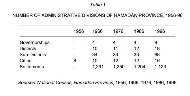
According to the national census of 1956, the present province of Hamadān used to be part of the province of Kermānšāhān, which was composed of the governorships (farmān-dāri) of Hamadān, Tuyserkān, Malāyer, and Nehāvand. The governorship of Hamadān had a total population of 695,283, of which 178,949 lived in eight cities (Zanjāni and Raḥmāni, p. 23). It was upgraded to the general governorship (farmān-dāri-e koll) of Hama-dān in 1966, but in the following censuses it was promoted to the province (ostān) of Hamadān and its area underwent minor modifications: 20,172 km2 in 1966 and 1976, 19,445 km2 in 1986, and 19,493 km2 in 1996 (Zanjāni and Raḥmāni, p. 6).

The internal division of this province within its present boundaries is shown in Table 1 (Zanjāni et al., p. 7).

Mountains. Hamadān is a mountainous region, located on the eastern flanks of the Zagros range, which stretches from the northwest to the southeast of Persia. The highest point, Alvand Kuh (q.v.), reaches an altitude of 3,580 m above sea level. A mass of granite and diorite, Alvand Kuh extends across the southern and eastern parts of the city of Hamadān and is its most prominent landmark. There are at least 12 other peaks in the Alvand range of more than 3000 m altitude. The lowest point of the province, where the river Gāmāsiāb flows out of the governorship of Nahāvand, descends to the altitude of 1,420 m (Jaʿfari, pp. 77-79; Faraji, p. 1290; Fāṭemi, p. 2). An interesting feature of the Hamadān–Kermānšāh area as far as the Bušehr region is that “the folds are extremely regular, straight in form and parallel in strike, and relatively packed together” (Fisher, p. 17).

Figure 1. The Province of Hamadān, based on Sāzmān-e naqšabardāri-e kešvar, Aṭlas-e melli-e Irān, Tehran, 1994; and Markaz-e āmār-e Irān, Farhang-e ābādihā-ye kešvar XXII, Tehran, 1970.

Other major mountains include Mount Garu (3,316 m) in the Halilān rural district south of Nehāvand, forming the natural frontier between Hamadān and Lorestān; Mount Lašgardar (2,928 m) to the southeast of Malāyer; Mount Ḵāngurmaz (2,868 m) in the Korzānrud rural district, northwest of Tuyserkān; Mount Siāh-darra (2,818 m) northwest of Tuyserkān; Mount Safid Kuh (2,475 m) in the rural district of Darjazin-e ʿOlyā, northeast of Hama-dān; Mount Garmā and Mount Sarmā in Malāyer; Mount Almuqulāḵ (2,997 m) between Asadābād and Bahār, 36 km from Hamadān; and Mount Buqāti in the Sard-rud district of Kabudar-āhang, about 85 km northeast of Hamadān. Finally, the Ḵaraqān range forms the natural frontier between Hamadān and the provinces of Qazvin and Zanjān (Fāṭemi, p. 2; Razmārā, Farhang V, p. 480; Jaʿfari, pp. 77-79, 120, 212, 232-34, 318, 342, 429, 472).

The governorships of Hamadān and Tuyserkān are perched on the north and south sides of the Alvand range, respectively. The plains are mainly situated in the northeast and east, extending from Hamadān to Āvaj (in the province of Qazvin) and also in the south, between Tuyserkān and Malāyer.

Climate. Hamadān’s climate is characterized by fairly long, cold winters (between 120 and 140 days of frost) and mild summers. The weather becomes gradually milder as we move from the northern highlands and plateaus towards the south. The northern valleys and vast plains are also exposed to northern and northwesterly winds in the winter, blowing with an average speed of 4 m per second. They are generally humid and bring about rainfall (Razmārā, Farhang V, p. 480; Faraji, p. 1290). The west-east winds blow in the autumn and the local winds (like the blind wind of Asadābād) are brought about by difference in air pressure due to differences in altitudes.

The temperature varies between minus 32 Celsius in winter to 39 Celsius in summer, with average temperatures between minus 4 (in December) and 25 (in July). Mountain tops are snow-covered from six to eight months of the year.

Precipitation has fluctuated between 280 and 420 mm in recent years, with an average of 315 mm. This has enabled Hamadān to sustain a relatively prosperous agriculture. The rainfall is almost equally divided into two periods of six months from November until April. There is practically no rain from June to September (Eṣlāḥ ʿArabāni, p. 1291; Markaz-e āmār-e Irān, 1999, pp. 12, 14, 16, 18, 20).

Rivers. Hamadān’s rivers are generally fed by the snow accumulated on the mountains and the rainfall in the wet seasons. During the summer the river beds, except for major rivers such as Gāmāsiāb and Siminarud, are entirely dry or reduced to mountain streams. The Alvand highlands form the watersheds, and Hamadān’s rivers may be divided into those flowing north and east of Alvand Kuh and those flowing south of it.

Rivers flowing north and east of the Alvand range are mostly seasonal and their discharge fluctuates enormously. The main rivers: 1) The Talvār River begins its course on the slopes of Kuh-e Safid mountain in the northwest of the province and is a tributary of the Safidrud (called Qezel Üzen before reaching Gilān) River, the longest river in Persia (765 km), which flows into the Caspian Sea at Ḥasan Kiāda. 2) The Qaračāy (or Siāhrud) River, also known as Quričāy in some parts of the province, begins its course on the highlands of the Zāḡa Pass and Yāl-darra, between Malāyer and the city of Hamadān, and passes through the northern valleys of the Alvand, where it is joined by a number of other rivers, including Siminarud, Ḵāku, and Farjin; thereafter, it continues its easterly course, passes through Kurijān in the Ḥājilu rural district, irrigating farmlands, and eventually flows into Lake Qom in the Central Province (Razmārā, Farhang V, pp. 480-81; Jaʿfari, pp. 153, 273-75, 329-31, 340; Qarāguzlu, pp. 20-22).

Rivers flowing south and southwest from the highlands of the Alvand range are more permanent. The principal rivers : 1) The Gāmāsiāb or Gāmāsāb, the name of Karḵa River in its upper course, is one of the longest rivers in Persia. Its headwaters, Sarāb-e Gāmāsiāb, are in the valleys of the Alvand Kuh in the southeast of the governorship of Nehāvand. After passing through the plains of Nehāvand and irrigating farmlands, it is joined by the Malāyer River and, further down, by the Qelqelrud River; then, crossing the Zagros Mountains, in a southwest direction, receives the name Karḵa and eventually joins the Kārun River. 2) The main sources of the Qelqelrud River are in the southern slopes of the Alvand Kuh; it is formed by the joining of several smaller rivers and streams before it flows into the Gāmāsiāb (Keyhān, I, pp. 74-76; Jaʿfari, pp. 336-37, 414-17; Razmārā, Farhang V, pp. 480-81; Schwartz and Miquel, p. 653).

Irrigation. The area is well supplied with water resources, provided by the Alvand Kuh. Besides the rivers, there are some 1,524 old qanāts (man-made subterranean canals carrying water from mountainsides to villages and farms). 3,027 springs, 6,172 deep wells, and 5,387 semi-deep wells are actually being exploited (Markaz-e āmār-e Irān, p. 21). Hamadān is fairly well supplied with underground water, especially in the regions of Bahār, Qahā-vand, and Nehāvand (Faraji, p. 1294).

The most important dam is Ekbātān (formerly Šahnāz) Dam, which was constructed in 1963 on the Yālfān River in the ʿAbbāsābād valley at about 10 km to the southeast of Hamadān city. This dam has a reservoir of 12 million cubic meters and supplies some 2,400 liters of water per second, of which 2,100 liters go to agriculture and 300 liters are used for drinking (Desmet-Grégoire and Fontaine, p. 33). There are also some minor earth dams built for irrigation purposes, and several more are under construction (Faraji, p. 1295).

Vegetation and wildlife. In the past this region was mostly covered by natural forests (mainly oak) and woodlands, of which only a small part has remained, mostly in the valleys of Mount Alvand. This is estimated to add up to some 4.1 thousand hectares, compared to 905 thousand hectares of pastures, that is, almost 46 percent of the total area of the province; many are in the valleys and plateaus of the Alvand Kuh. More than half of these pastures are of poor quality, however (Markaz-e āmār-e Irān, p. 179).

On the other hand, the total area of agricultural land is approximately 950 thousand hectares, including some 630 thousand hectares for dry farming (Fāṭemi, p. 123), which accounts for another 48 percent of Hamadān’s total area. Only 6 percent of the province’s surface is left with no vegetation.

Many of the wild plants found here have pharmaceutical applications. Among them gavan, or goat’s thorn, which is very common in the valleys of the Alvand, is of significant economic value, as its gum, tragacanth (katirā), is extensively used in both medicine and industry (Fāṭemi, p. 34).

There are many scenic, grass-covered mountain valleys between the peaks, some with fountains flowing out and small lakes visited by migrating birds and other wildlife, forming semi-autonomous ecosystems. One such lake, Tālāb-e Āqgol, a seasonal marsh located some 20 km south of Malāyer, is visited every year for four to five months by between 10 to 20 thousand birds, such as geese, ducks, herons, cranes, aigrette, and other migrating birds on their way from the wetlands of Siberia and Scandinavia to warmer territories (Fāṭemi, p. 38).

There are also several wildlife reserves that are home to such birds of prey as royal eagles, golden eagles, falcons, hawks, owls, vultures and prey species such as partridges, wild fowl, hares, and rabbits, as well as larger mammals such as rams, wild goats, ibexes, wild boars, and predators such as wolves, foxes, jackals and hyenas. The predator-prey relationship seems, in general, according to the available data, to be fairly well balanced. The data for the years 1994-98 show no particular trends in the number of animals observed, except for a clear decline in the number of ducks and geese, from about 4,500 to about 2,200. The number of wolves, foxes, and jackals has remained fairly constant at around a hundred, while the number of hyenas has been remarkably stable at around twenty (Markaz-e āmār-e Irān, pp. 24-25).

Economy. As pointed out above, ample water-supply and more than average rainfall have enabled Hamadān to sustain a fairly prosperous agriculture. In fact, agriculture remains the principal economic activity in the province. Availability of primary products (both agricultural and mineral), has been conducive to industrial activity.

Agriculture. While Hamadān’s area constitutes 1.2 percent of the area of the whole country, its share of land under cultivation is estimated to be 4.5 percent, which is more than 3.5 times its share of the surface. Around 48 percent of Hamadān is covered by agricultural land, of which about 52 percent is under cultivation. However, about two-thirds of the agricultural land is under dry farming (deym), which generally yields less than one third of the irrigated land, and about half of the area under cultivation is fallow. Wheat and barley account for the bulk of the area under cultivation. 
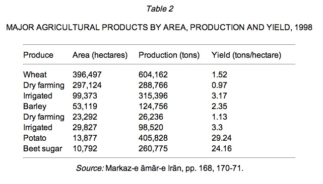
Table 2 illustrates the relative importance of various products in 1998.

Orchards account for about 6.1 percent of cultivable land. Annually about 2.2 to 2.6 million tons of agricultural products are produced in Hamadān, which is about 4.8 percent of the produce of the country as a whole (Fāṭemi, p. 124).

Industry. Hamadān has been known for its handicraft industry, including tanning (see DABBĀGĪ), carpet-weaving, ceramics (qq.v.), and knitting for a long time, and in 1998 some 1,443 production units were active in this field. Hamadān’s contemporary industrial activity extends from light to heavy industry, including the production of food (dairy products, canned fruits, sugar, soft drinks), textiles, plastics, household goods, mining, construction and metallurgy. During the period 1994-98, a total of 453 industrial operation permits were issued. In 1995, there were 266 large industrial units in operation in Hamadān, employing 8,620 people (Markaz-e āmār-e Irān, pp. 188, 191-92). Large units producing agricultural and construction machinery, aluminum products, and steel are already operational or under construction.

Hamadān is fairly rich in minerals, including granite (the most important source of it in the country) and ornamental stones, limestone, silica, lead, zinc, and iron ore. In 1998, there were 142 active mines in Hamadān, including 52 sandstone, 36 silica, 19 ballas, 13 ornamental stones, and 14 limestone mines, employing 819 persons (Markaz-e āmār-e Irān, pp. 198-99).

There are 2,034 km of inter-city roads in Hamadān, of which 236 km are highways and 492 km are main roads; the rest are secondary roads. There are also 3,068 km of rural roads of which 2,507 are macadam (Markaz-e āmār-e Irān, pp. 227-28).

Languages spoken. Hamadān has been a crossroads of civilizations for millennia and a mosaic of cultures and dialects live there side by side. The main language spoken, especially in the provincial capital and its surroundings, is Persian, which is also the lingua franca in other regions. In the northern parts of the province, however, the language mostly spoken is Azeri Turkish, while in the northwest and west, near the provinces of Kurdistan and Kermānšāhān, people mostly speak Kurdish, while in some other cities such as Malāyer, Nehāvand, and Sāmen most people speak Lori and Lak (Faraji, p. 1296).

Bibliography:

Rabiʿ Badiʿi, Joḡrāfiā-ye mofaṣṣal-e Irān, 3 vols., Tehran, 1988.

Dāyera-ye joḡrāfiāʾi-e Setād-e arteš, Rāhnemā-ye šahr-e Hamadān, Tehran, 1952.

Moḥammad Borhāni and Āryā Partovi Deylami, Gozāreš-e moṭālaʿāt-eābhā-ye zir-e zamini-e Hamadān, Tehran, 1982.

Hélène Desmet-Grégoire, “Le pain dans le région d’Hamadān (Iran),” Stud. Ir. 9/2, 1980, pp. 251-76.

Idem and Patrice Fontaine, La region d’Arak et de Hamadan: cartes etdocuments ethnographiques, Stud. Ir., Cahier 6, Leuven, 1988.

Eckart Ehlers, “Der Alvand Kuh: Zur Kulturgeographie eines iranischen Hochgebirges und seines Vorlandes,” in Adolf Leidlmair-Festschrift, Insbrucher Geographische Studien 5, 1979, pp. 483-500.

Idem, Iran: Grundzüge einer geographischen Landeskunde, Darmstadt, 1980, pp. 61-62, 91-92, 293-94, 379-81.

Ebrāhim Eṣlāḥ ʿArabāni, ed., Rāhnemā-ye šahrestānhā-yeIrān, Tehran, 1966, pp. 518-26.

ʿAbd-al-Reżā Faraji, ed., Joḡrāfiā-ye kāmel-e Irān, Tehran, 1987.

Sayyed Abu’l-Ḥasan Fāṭemi, Simā-ye gardeš-gari-e ostān-e Hamadān, Hamadān, 2001.

W. B. Fisher, “Physical Geography,” in Camb. Hist. Iran I, pp. 3-110.

Gazetteer ofIran I, pp. 176, 219-23, 430, 486, 668.

ʿAbd-al-Rafiʿ Ḥaqiqat “Rafiʿ,” Farhang-e tāriḵi o joḡrāfiāʾi-e šahrestānhā-ye Irān, Tehran, 1996, pp. 641-44.

Kano Hiromasa, “City Development and Occupational Change in Iran: A Case Study of Hamadan,” The Developing Economies 16/3, Tokyo, pp. 298-328.

A. V. Williams Jackson, Persia Past and Present, New York and London, 1906, pp. 146-50.

ʿAbbās Jaʿfari, Gitā-šenāsi-eIrān I: kuhhā wa kuh-nāma-ye Irān, Tehran, 1989.

Idem, Gitā-šenāsi-e Irān II: rudahā wa rud-nāma-ye Irān, Tehran, 1997.

Masʿud Keyhān, Joḡrāfiā-ye mofaṣṣal-e Irān, 3 vols., Tehran, 1932, I, pp. 59-60; II, pp. 379-86.

Markaz-e āmār-e Irān, Šenās-nāma-ye āmāri-e šahrhā-ye ostān-e Hamadān, Tehran, 1996.

Idem, Āmār-nāma-ye ostān-eHamadān, sāl-e 1377, Tehran, 1999.

Moʾassesa-ye ʿāli-e pažuheš dar barnāma-rizi wa tawseʿa, Ṭarḥ-e moṭāleʿāt-e jāmeʿ-e tawseʿa-ye Ostān-e Hama-dān, Section 2: Omur-e ejtemāʿi, Tehran, 2002.

Xavier de Planhol, “Geography of Settlement,” in Camb. Hist. Iran I, pp. 409-67.

Ḡolām-Ḥosayn Qarāguzlu, Hagmatāna tā Hamadān, Tehran, n.d., pp. 19-23, 93-126, 515 ff.

Razmārā, Farhang V, pp. 353, 432-35, 460-62, 479-86, 512-17.

P. Schwartz and A. Miquel, “Karkha,” in EI2 IV, pp. 653-54.

Ḥabib-Allāh Zanjāni et al., Sawābeq-e jamʿiati-e šahrhā wa ābādihā-ye Ostān-e Hamadān, publication nos. 2-4, in Ṭarḥ-e kālbodi-e melli, Markaz-e moṭāleʿāt wa taḥqiqāt-e šahr-sāzi wa meʿmāri-e Iran, Tehran, 1992, p. 7.

Ḥabib-Allāh Zanjāni and Faridun Raḥmāni, Rāhnemā-ye jamʿiat-e šahrhā-ye Irān 1335-1370, Tehran, 1989.

(Parviz Aḏkāʾi and EIr)

Originally Published: December 15, 2003

Last Updated: March 6, 2012

This article is available in print.
Vol. XI, Fasc. 6, pp. 595-599

Cite this entry:

Parviz Aḏkāʾi and EIr, “HAMADĀN i. GEOGRAPHY,” Encyclopædia Iranica, XI/6, pp. 595-599, available online at http://www.iranicaonline.org/articles/hamadan-i (accessed on 30 December 2012).