


FĀRS
vi. Population
The province of Fārs is the largest and the most populous province in the south of Persia. In the last national census (1996) it was composed of 16 counties (šahrestāns), comprising a total of 60 districts (baḵš), 48 towns (šahr), and 185 village clusters (dehestān). Its geographical boundaries and internal subdivisions, however, have undergone several changes in recent years (Table 1.
The separation of the township of Eqlīd from the county of Ābāda and its conversion into the county of Eqlīd, and the breaking up of the county of Shiraz into the three counties of Shiraz, Sapīdān, and Marvdašt between 1966 and 1976; the breaking up of the county of Lār into the counties of Lār and Lāmard between 1986 and 1990; and the conversion of the township Bavānāt to the county between 1991 and 1996 have been the main changes in the internal sub-divisions of Fārs. Between 1966 and 1986 a total of 11 settlements were separated from this province and joined to the provinces of Yazd and Kohgīlūya and two settlements were separated from the province of Hormozgān and joined to Fārs.
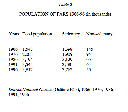
Given that reductions in the area of the province since 1966 have been due more to differences in the methods of measurement than to changes in the boundaries of the province, the population of Fārs in its present boundaries has varied as shown in Table 2. These figures show that in the thirty year period 1966-96, while the total population of Fārs has increased approximately 2.5 times, its tribal and non-sedentary population in 1996 has fallen to 38 percent of its 1966 level.
Population density. Dividing the restructured population of the present boundaries of Fārs to its area in 1996 (117,117 km2) shows that the population density of Fārs has changed from 15.4 persons per km2 in 1966 to 20.1 in 1976, 32.0 in 1986 and 38.2 in 1996, which correspond closely with the average population density in Persia (15.6 in 1966 and 36.8 in 1996). The variation in population densities in the counties in 1996 ranged from 6.4 persons per km2 in Bavānāt to 146.1 in Shiraz. The counties of Kāzerūn (63.0), Marvdašt (61.4), and Fasā (47.1) followed Shiraz at the top and the counties of Eqlīd (11.3), Neyrīz (11.6), and Lār (12.7) preceded Bavānāt at the bottom of the scale (National Census, Ostān-e Fārs, 1966, 1976, 1986, 1996).
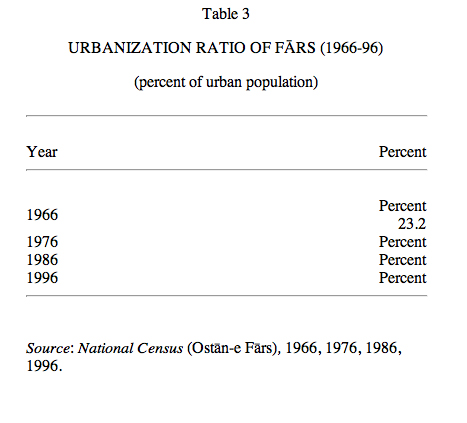
Urban and rural populations. The ratio of urbanization in Fārs rose from 39.8 percent in 1966 to 56.7 percent in 1976. This is partly due to the enlargement of the villages and partly due to the merger of surrounding settlements into the cities. If for comparative purposes the current forty-eight urban centers are considered as ‘cities’ throughout these years, the following urbanization ratios are obtained (Table 3).
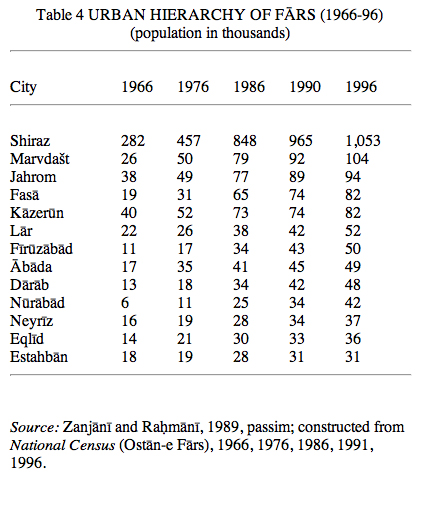
Urban hierarchy. The 1996 National Census registered thirteen large and middle-sized urban centers with more than 25,000 inhabitants in the province of Fārs. Following the uneven national pattern of urban hierarchy, the distribution of population among various urban centers in Fārs shows a great difference between the rank of the capital city of Shiraz on the peak of the urban hierarchy (with one million inhabitants or over one-half of the total provincial urban population) and the second city on the scale, i.e., the city of Marvdašt with over 104,000 population, counting only as one-tenth of the former. The distribution of urban population among other urban centers, ranging from 94,000 in Jahrom to 31,000 in Estahbān (formerly Esṭahbānāt) shows a balanced distribution (Table 4).
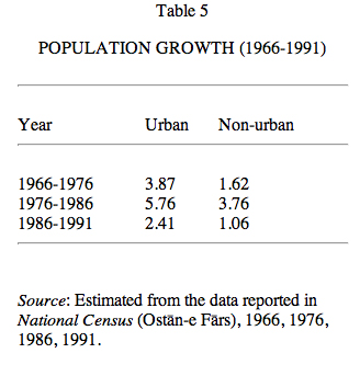
Population Growth. Between 1966 and 1996 the average rate of the growth of population of Fārs was 2.47 percent (4.00 percent urban and 2.14 percent rural); it rose from 2.65 percent between 1966-76 to 4.78 percent between 1976-86 and then fell to 1.80 percent. Table 5 gives the breakdown for ‘restructured’ urban and non-urban (rural, tribal and migratory) populations.
Migration and displacement. In 1956 the province of Fārs o banāder had a negative net balance of migration of -58,197, and immigrants to and emigrants from this provinceaccounted respectively for 2.03 percent and 6.45 percent of total displacements in Persia. In the present boundaries of Fārs this figure reached -41,224 in 1976. Between 1976 and 1986, war related emigrations from the western provinces to Fārs brought about a weak positive balance of +3,571. In the following decade, with the return of the war-stricken migrants, once again the number of emigrants (146,116) exceeded the number of immigrants (140,079). Compared to its total population, the balance of migration of Fārs is relatively unimportant and has played an insignificant role in its population dynamics, which have been largely affected by natural factors (birth and death rates); instead, emphasis should be laid on the evolution in the structure of the urban and rural populations (estimated from National Census, total country and Ostān-e Fārs, 1956, 1966, 1976, 1986).
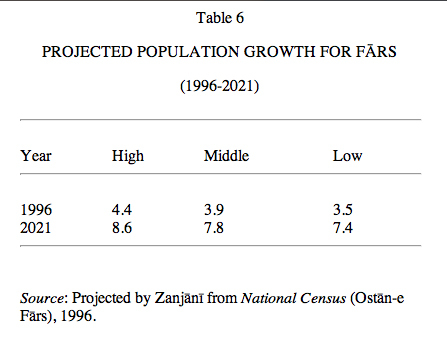
Perspectives. As migration is insignificant and the effects of foreseeable changes in death rate are limited, the rate of fertility seems to be the most important determining factor in the structure and volume of the population of Fārs. The latest available data on fertility are for 1986 and 1991. These data show that during this period of five years the rate of fertility dropped from 5.70 to 5.05 offspring and with it the birth rate fell from 42.2 to 37.4 per thousand, a gradual decrease of 8.86 per cent (1.77 per cent per annum). This corresponds with the projection of population growth on the national scale. Using the adjusted statistics for 1991, the population of Fārs is thenceforth projected for the period 1996-2021, based on three hypotheses (Table 6).
Given the data provided by the census of 1996 (3,817,036) and the fact that they are underestimated, it seems that the second hypothesis is closer to the reality. At the end of this period, according to these projections, the ratio of the urban population will amount to about 63 per cent.
Bibliography
(for cited works not given in detail, see “Short List”):
For a bibliography of fifty surveys and census reports on various aspects of population of Fārs, see Sāzmān-e barnāma wa būdja-ye ostān-e Fārs, Fehrestgān-e Fārs I, 1369 Š./1990, pp. 72-80.
National Census, 1956, 1966, 1976, 1986, 1991, 1996.
H.ṟ Zanjānī and F. Raḥmānī, Rāhnemā-ye jamʿīyat-e šahrhā-ye Īrān, 1335-1370, Tehran, 1368 Š./1989.
Ḥ. Zanjānī and Z. Nabīzāda Tabrīzī, Sawābeq-e jamʿīyatī-e šahrhā wa ābādīhā-ye ostān-e Fārs dar maḥdūda-ye taqsīmāt-e kešvarī-e sāl-e 1365 az sāl-e 1345 ba baʿd, Tehran, 1371 Š./1992.