

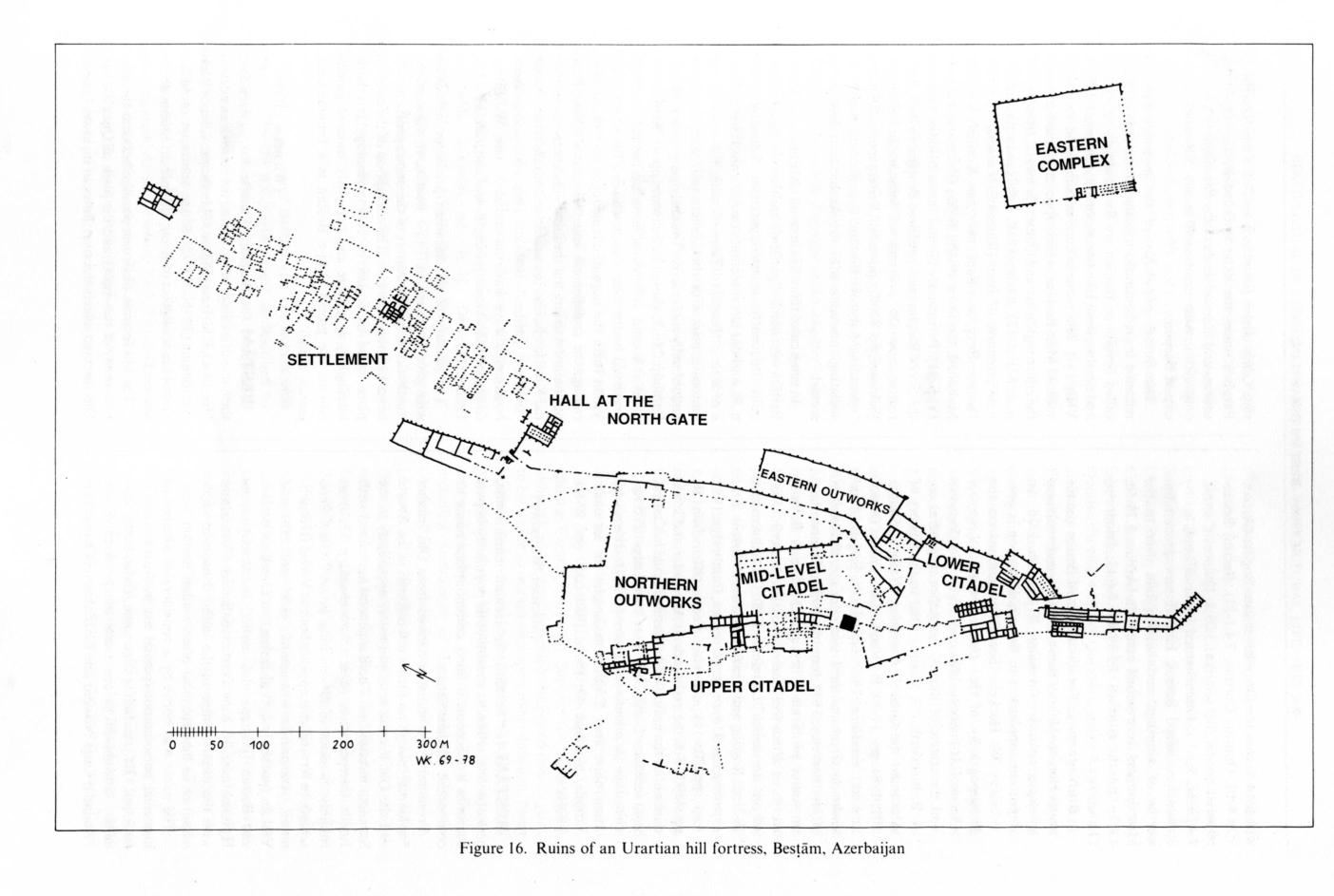
BESṬĀM (or Basṭām), Elamite Rusa-i Uru.Tur, the name of a village at the foot of the ruins of an ancient Urartian hill fortress (Figure 16) in the province of West Azerbaijan (39° N, 45° E), 85 km southeast of Mākū and 54 km northwest of Ḵᵛoy; altitude ca. 1,300 m above sea level.
The hill fortress obstructs passage between the narrow valley of the Āqčāy and the plain of Qara Żīāʾ-al-Dīn through which the river flows in its lower course. The plain has been intensively cultivated by means of irrigation canals ever since the Urartian period. A road from Tuspa (Van), the Urartian capital, led to Rusa-i Uru.Tur and thence to the eastern parts of the Urartian realm.
Evidence of human occupation of the Besṭām area from the 3rd millennium onward has been obtained from a mound at the foot of the hill within the precinct of the present village. The Urartians first used the site as a staging post on the road. Probably in the 9th-8th century b.c., they built a castle measuring 165 x 35 m on the ground later occupied by the south gate of the citadel. This castle was largely demolished when the citadel was built in the 7th century b.c.
Rusa-i Uru.Tur (Rusaδs town) was founded by Rusa II (685-45 b.c.), probably soon after his accession. An inscribed stone, found at Mākū in 1910 by Count Kanitz and now (since 1965) in the Īrān-e Bāstān Museum at Tehran, gives a number of Urartian place names and royal names and mentions the foundation of a temple of the god Haldi. Toward the end of Rusa II’s reign Rusa-i Uru.Tur was plundered and destroyed by fire. The site was partly reoccupied and built over in the Median-Achaemenian period, in the Parthian-Sasanian period, and again in the 3rd-7th/9th-13th centuries when an Armenian fortress and village were superimposed; after the Mongol invasion it was abandoned permanently.
German archeologists reconnoitered the site in 1967. Excavation began in 1968 and was continued annually (except in 1971 and 1976) until events in Iran brought the work to a halt in 1979.
The remains fall into three groups:
1. The eastern complex, Urartian from the 7th century b.c., built on a rectangular plan with external dimensions of 162 x 130 m, stands alone in the valley opposite the fortress at a distance of ca. 365 m. The outer walls are in sections divided by buttresses. The gate is on the east side, flanked by guardrooms and leading to a long, three-aisled stable building. The functions of the complex were all connected with horses.
2. The settlement at the north foot of the hill fortress, 600 m long and 300 m wide, built in the 7th century to accommodate officials and merchants who served the fortress garrison. The houses had several rooms each and were rectangular, facing west. Around the settlement stood some isolated buildings of larger size, namely, the north building, the east building, and the hall-like building near the north gate of the citadel. The settlement was abandoned when the fortress fell.
3. The fortress, 800 m long and ca. 400 m wide overall, built in the 7th century b.c. in three phases, as follows:
(i) The nucleus, designed for defense and other functions and made up of: A. The lower citadel, 380 x 110 m, containing the south gate, some stables, quarters for troops, a house (for their commander ?), kitchens, etc., for the garrison; intended to block the narrow Āqčāy valley, it was built on the site of the earlier staging post. B. The mid-level citadel, 200 x 130 m, containing the square, tower-shaped temple of Haldi (foundations 14 x 14 m) with terraces preceding it, reception halls, extensive storerooms in which numerous large storage jars (pithoi), some 2.06 m high and 1.30 m wide, were found, and a meat locker (15 x 4.50 m), subsequently burned down, in which were found some 600,000 bones of animals and 1,240 clay seals evidently used to keep account of meat stocks, some with incised stamps, others with marks applicable by rolling. C. The upper citadel, 90 x 50-75 m, containing the governor’s residence, which at times was probably also a royal residence, the town having been a dependency of Urartu and a last refuge for its kings in times of danger.
(ii) The northern outworks, together with the north terrace and the north gate, added at a later time to augment the defensive strength of the citadel and improve the northern access from the settlement.
(iii) After this first enlargement, further extensions were built. The outer north gate was added to the northern outworks, the slope down to the settlement was built over, and the eastern outworks were constructed as an additional defense line. The western slope was also built over. The south gate was strengthened by the addition of a tower.
Noteworthy finds of small objects are two clay tablets inscribed with royal instructions to officials, fragments of other clay tablets, part of a gold sheet in the form of a ring with a border of leaves (probably a furniture attachment), many bullae with impressions, four cylinder seals, a clay drinking vessel coated with red slip and shaped like the head of a gazelle, fragments of stone reliefs with a crenellated design, and a large assortment of Urartian pottery including specimens of the fine Urartian red ware as well as objects of everyday use.
Bibliography:
The principal reports on Besṭām are “Vorlagen der Grabungsergebnisse,” Istanbuler Mitteilungen 18, 1968, pp. 23-31, and AMI, N.S. 3, 1970; 5, 1972; 6, 1973; 7, 1975.
W. Kleiss, Bastam/Rusa-i Uru.Tur. Beschreibung der urartäischen und mittelalterlichen Ruinen, Berlin, 1977.
S. Kroll, “Keramik urartäischer Festungen in Iran,” AMI, Ergänzungsband 2, 1976.
W. Kleiss et al., Bastam I. Ausgrabungen in den urartäischen Anlagen 1972-75, Berlin, 1979.
Idem, Bastam II. Ausgrabungen in den urartäischen Anlagen 1977-1978, forthcoming.
On the Mākū inscription see F. W. König, Handbuch der chaldischen Inschriften, Archiv für Orientforschung, Beiheft 8, 1955, no. 129.
Figure 16. Ruins of an Urartian hill fortress, Besṭām, Azerbaijan
Search terms:
| بسطام | bestam | bestaam | bastam |
(Wolfram Kleiss)
Originally Published: December 15, 1989
Last Updated: December 15, 1989
This article is available in print.
Vol. IV, Fasc. 2, pp. 175-177