

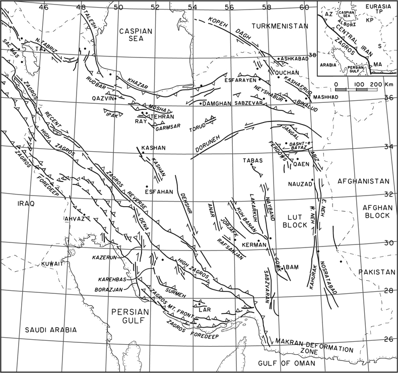
BAM EARTHQUAKE of December 26, 2003. A moderate-magnitude (Mw 6.6) earthquake struck the city of Bam and its surroundings in southeast Iran (29.10˚N-58.35˚E) at 05:26 AM local time (01:56 GMT) on Friday 26 December 2003/5 Dey 1382 (FIGURE 1). The night before the main shock (25 December), two strong foreshocks that caused considerable alarm and panic were felt at approximately 15:00 and 22:00 local time (i.e. 14.5 and 7.5 hours before the main shock). Another foreshock was strongly felt 35 minutes before the main shock (December 26 at 04:33 local time).
The earthquake, occurring at the early hours of the morning in winter when most people were in bed, resulted in the highest casualty rate and the most profound social impact in the recorded post-1900 history of devastating urban earthquakes in Iran (see Table 1 and Figure 2 in Berberian, 2005), in spite of its moderate magnitude. It also illustrated the terrible humanitarian and economic consequences of poor natural disaster planning and preparation for such extreme geological events in the wider context of recent catastrophic earthquakes that have devastated different parts of the country, at least since the Buyin Zahrā (Mw 7.0) earthquake, which struck the area west of the capital city of Tehran on 1 September 1962/10 Šahrivar 1341 (Berberian et al., 1983). About one earthquake of a magnitude similar or higher than the Bam 2003 earthquake occurs every week worldwide (NEIC; ISC), yet few of them result in such a tragedy.
Pre-2003 earthquake demography. Bam, an oasis town with date palms, orange trees, eucalyptus, and oleander, is located at the western edge of the Lut desert, on the eastern frontier of Kermān province in southeast Iran. It has been a walled stronghold in the region between Kermān and Baluchistan provinces, plagued by repeated incursions and banditry, and frequently sacked by invading Afghans, Ghozz Turks, and Baluchis. It was the scene of the last stand against the Qajars by the Zand dynasty in 1795. Aside from date farming, the economy of Bam was chiefly based on the cotton and silk industries, which sustained a prosperous artisan class. Since historic time, wells and traditional underground irrigation channels (qanāt/kāriz) have been the main source of urban and rural water supply.
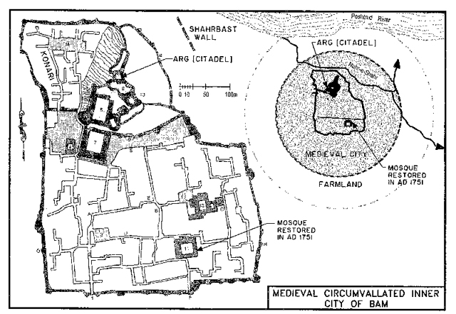
The medieval circumvallated inner city of Bam (Arg, Kohandež [the Old Citadel], FIGURE 2) was considered a strong fortified town in the 11th and 12th centuries when it was captured and fortified by theSeljuk (Saljuq) Turks. The city and its immense walls were destroyed and rebuilt several times; and most of the remaining constructions date back to no earlier than the late-Safavid period. There are at least 12 major phases of documented reconstruction of the Bam Arg prior to 1840 (See Table 3 in Berberian, 2005). The Friday mosque of the Bam Arg, which stands at the site of the destroyed medieval Friday mosque (# 1 in FIGURE 2), was last repaired in 1751 (Gaube, 1979). This indicates that since 1751 the Bam region had not experienced a destructive earthquake (Berberian, 1976, 1995, 1996, 2005; Berberian and Yeats, 1999, 2001).
The 20-hectare Citadel was a complex structure consisting of four interconnected fortifications with 48 watchtowers (FIGURE 2). Surrounding the Citadel was a deep moat, which was partially intact. Inside the moat is the Citadel’s first wall and ramparts, behind which were the ruins of buildings where evidently the urban middle class and the Citadel’s guards made their homes. This lower area contained the entrance complex and the barracks and stables constructed in mud-brick, and used low domes and shallow barrel-vaults. The mud-brick walls were massive with an impressively designed gatehouse. Next came a second wall behind which were the homes of the more eminent and affluent citizens, and finally, protected by a third wall, and on the pinnacle of the Citadel were the seat of the governor and the residence of high dignitaries and officials.
The present city of Bam (FIGURE 3) was founded in 1840, when most of the population moved from the medieval circumvallated inner city. Prior to the 2003 earthquake, there were 102,087 people living in non-engineered or non-seismically resistant indigenous structures in the city of Bam (with 40% of population under the age of 20), approximately 16,000 in the town of Baravāt, and about 10,000 in the nearby villages. In 2002, there were 55,330 students, 2,958 teachers, and 2,536 classes in 131 schools in the Bam sub-province (Šahrestān). The sub-province had approximately 3,800,000 date palm trees cultivated in approximately 19,000 hectares. During the same period, the area suffered from an unemployment rate of 25%, a maternal mortality rate of 37/100,000, infant mortality rate of 29/1,000, and under 5 years old mortality rate of 37/1,000. According to official figures, 10% of the population lived below the universal poverty line of less than one US dollar a day (UN Flash Appeal, 2004; SCI, 2004; Tiernet et al., 2005).
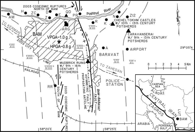
General earthquake impact. In spite of the existence and availability of sufficient scientific and technical knowledge and capability in early twenty-first century to counteract such a natural disaster, this particular moderate-magnitude earthquake completely destroyed the city of Bam (where both the old and the new buildings collapsed at once), along with the historic Bam Citadel (Arg; approximately 20 hectare of land constructed entirely of earthen material); it severely damaged the town of Baravāt, and destroyed at least eleven nearby villages of Akbarābād, Amirābād, Dašt-e-Gāv, Espikan, Ḥosaynābād, Kāᵛāja bālā, Poštrud, Raḥimābād, Zeydābād, Čeheltoḵm, and Ziaratgāh-e Davāzdah Emām (FIGURE 3). Approximately 31,824 to 43,000 people lost their lives in the Bam sub-province (out of a total population of 142,376), between 17,500 to 20,000 people suffered injuries in the city of Bam (of which 9,500 were seriously injured) requiring hospitalization, yet all the functioning three hospitals (with 240 beds) and 122 health centers in the area were completely destroyed or badly damaged. In total, about 30,000 people were injured in the Bam sub-province, 400 became permanently disabled, 75,000 were left homeless, 550 were unaccounted for, 5,054 children were put on the register as orphans, more than 230,000 people were affected in the region, and the psychological impact was severe in the entire area (Iranian Newspapers, 2003, 2004, 2005; irna.ir, 2003, 2004, 2005; news.bbc.co.uk, 2003, 2004; AlertNet, 2003; SCI, 2004; IFRC, 2004a, b, c; RCS; reliefWeb.net; UNISDR; World Bank, 2004; megacities; radix; calearth.org; Berberian, 2005; Ghafory-Ashtiany and Mousavi, 2005; Tierney et al., 2005; Khazai and Hausler, 2005).
Earthquake surface faulting, strong ground motion, and aftershocks. The Bam earthquake involved ground surface rupture of nearly vertical north-south trending right-lateral strike-slip fault (Talebian et al., 2004; Wang et al., 2004; Funning et al., 2005) extending directly southward from Bam for about 15 km (FIGURE 3). Although the earthquake fault slipped at shallow depth, little of this slip reached the ground surface, and the earthquake fault was unknown before the 2003 earthquake. The locally recorded aftershocks during January 2004 indicated strike-slip faulting that extended approximately 30 km N-S (much longer than the mapped co-seismic surface fault) underneath the city of Bam, with focal depths located between 6 to 20 km below the surface (Tatar et al., 2005). There was a conspicuous absence of locally recorded aftershocks from the slip patch (0-6 km below the ground surface). The strong ground motion produced by this moderate-magnitude earthquake was recorded by a Kinemetrics SSA-2 accelerograph installed and maintained in the governor’s building in the city of Bam by the Iranian Building and Housing Research Center (BHRC, 2003, 2004; Shoja-Taheri et al., 2005). The subsoil condition in Bam is hard and the Eocene volcanic bedrock lies only about 25 m below the ground surface (GSI, 1993; Towhata et al., 2004).
Three geophysical factors (Bouchon et al., 2006), whose unfortunate combination led to the strong ground shaking with a peak vertical ground acceleration of nearly 1.0 g/980 cm/s², and horizontal acceleration of 0.8 g/779 c/s² (BHRC, 2003, 2004; Shoja-Taheri et al., 2005), coupled with the poor quality of the physical infrastructure and a lack of adequate risk management by the Iranian government led to the destruction suffered by the city of Bam. The three geophysical factors were: (i) the Rayleigh-like speed of the Bam rupture propagation over the Bam earthquake fault (which was associated with high slip-velocity and, hence, increasing near-fault motion), (ii) the high-slip velocity, which exceeded 2 m/s over a large part of the earthquake fault, and (iii) the strong directivity, resulting from the location of the hypocenter opposite the city relatively to the rupture area, which focused the elastic energy released directly toward the city of Bam. The Rayleigh-like speed of the Bam rupture implies that the Bam earthquake fault was a weak and mature seismogenic fault that broke easily (Bouchon et al., 2006).
Earthquake impact on buildings. It was the widespread failure of poor quality buildings that contributed to so many deaths in the area. Almost all who died during the earthquake were killed in buildings less than 30 years old. Nearly 90% of the buildings in Bam suffered 60-100% destruction, and the remaining 10% suffered 40-60% damage. The extent of destruction in some quarters of the city reached 100%. Almost 95% of the buildings in the city of Bam (approximately 25,000 buildings), the town of Baravāt (4000 buildings), and in a large percentage of the villages (24,000 buildings) within 10 km of the city were devastated or severely damaged. The highest intensity of ground shaking caused by the earthquake (Shoja-Taheri et al., 2005; Bouchon et al., 2006) was observed in the city of Bam itself, which was built on top of an earthquake fault line (FIGURE 3), and where approximately 12 million metric tons of collapsed building debris were piled up (NCC, 2003/2004; SCI, 2004; USAID, 2004a; Maheri et al., 2005; Maheri, 2005; Eshghi and Naserasadi, 2005).
As with previous earthquakes in Iran, nearly all the vernacular, conventional (amalgam of modern construction and local technology), and modern structures in Bam completely collapsed. Most of the earthquake fatalities were in the vulnerable adobe and masonry buildings, as well as in modern buildings less than 30 years old, which were poorly constructed. Even many of the steel-framed and steel-reinforced concrete buildings constructed over the last decade ended up with pretzel shaped steel frames on top of heaps of crumpled infill masonry walls and floors (Sanada et al., 2004; Hosseini and Jafari, 2004), indicating that the building code had not been enforced at the time of construction by the authorities.
Numerous factors such as (i) the high-frequency of ground vibration during the earthquake (Shoja-Taheri et al., 2005; Bouchon et al., 2006), coupled with (ii) additive changes made to the walls of the Bam Citadel, particularly in recent restorations, which resulted in variations in the density and response to strong ground motion of different layers of unfired earth construction in the wall, and (iii) extensive damage from termites and the loss of cohesion of the clay from degradation and excessive drying out (Langenbach, 2005), demolished the Citadel.
Earthquake impact on lifelines and the environment. Transportation systems (roads, bridges, railroad, and airport), though very limited, were moderately damaged and became generally operational soon after the earthquake to support a delayed emergency response and recovery effort. Numerous electrical transmission concrete poles were damaged in the electric distribution system (Moghtaderi-Zadeh et al., 2004; Eshghi and Razzaghi, 2005; Eshghi and Ahari, 2005).
There were several breaks in the water distribution systems and minor damage to deep wells. The elevated water tank in the old section of the city was severely damaged. The traditional qanāt system, which brings water from foothills tens of kilometers away through underground tunnels, was seriously affected (Pellet et al., 2005). Almost 30 qanāt irrigation systems (out of 64) collapsed due to strong ground motion in Bam, Baravāt, and the nearby villages. The qanāt failure caused severe damage to the underground water supply network of the Bam sub-province for drinking water as well as for the irrigation of the date palm and orange groves. The exact extent of leakage from petroleum storage tanks and barrels (Eshghi and Razzaghi, 2005), causing soil pollution and underground water contamination, has not been investigated.
Estimated direct and indirect economic losses. The duration of the reconstruction phase was projected to take three to five years, with costs estimated at 1.5 billion US dollars (World Bank, 2004). The direct economic loss of the earthquake was estimated at 1,500 million dollars (in original values). Furthermore, the earthquake caused approximately 53 million dollars in agricultural loss, 30 million in tourism, 15.8 million in industrial loss, and 91.3 million dollars in private business loss. The indirect economic losses due to the destruction of houses and loss of jobs has not yet been estimated or reported.
International aid. Forty countries sent aid to Iran soon after the earthquake, and the United Nations raised 7.0 million US dollars in aid for victims. As of January 15, 2004, the USAID Disaster Assistance Response Team (USAID/DART) and U.S. Department of Defense (USDOD) assistance to Iran was 3,702,645.00 dollars and 2,012,285.00 dollars, respectively (USAID, 2004b, c). According to the World Bank (2004), total economic damage was estimated at around 1.5 billion dollars. In May 2004, the World Bank provided a loan of 300 million dollars to help the Iranian government rebuild Bam’s shattered infrastructure. Members of the global alliance Action by Churches Together (ACT Netherlands), the U.S.-based Presbyterian Disaster Assistance (PDA), the Norwegian Church Aid (NCA), and Church of Sweden Aid assisted residents of the Bam area in the sectors of shelter, community groups and psychosocial care (Payvand Iran News, 2004). As of March 7, 2005, the total sum of 130,851,677.00 dollars was donated to the Bam earthquake project by more than 40 countries and international agencies (IFRC, 2004a, b, c; UNOCHA, UNDEP, UNESCO, FAO, IOM, WHO, WFP, UNFPA, UNHCR, ILO, and IRC) under the following ten categories: coordination and support services, economic recovery and infrastructure, education, family shelter, non-food items, food, water and sanitation, health, protection/human rights and rule of law, unspecified sectors, and security (USAID, 2004b, c).
National aid. Despite numerous efforts, data on national aid, local and Iranian Diaspora charities have not been available. The Iranian people both at home and abroad, together with traditional community-based organizations (CBOs), and humanitarian volunteer groups, helped the earthquake survivors by donating needed goods, medications, and money. Hamyaran [Supporters] Iran NGO Resource Center (registered in 2001), Association for Protecting Child Laborers (Tehran), Yaran [Helpers] (Tehran, organized after the Bam earthquake), together with the Kerman NGOs House (an umbrella association for more than 40 local relief agencies in Kerman), and Bam NGOs [Association for Protecting Child Laborers; Mashiz & Nobavaran (New Belief) Bam, among others], and other civil society organizations tried to play a massive, effective and prompt role during the crisis/relief and rehabilitation (temporary and permanent) phases. They also coordinated with the international and local NGOs, signed contracts with international associations and NGOs to help the earthquake victims with food for up to 10,000 people daily, undertook the role of coordinating information-collecting and sharing, and holding workshops for local NGOs (www.friendsofbam.org/hamyaran_report.html; www.hamyaran.org; Okano and Atsumi, 2004; Atsumi and Okano, 2004).
Post-earthquake rescue and recovery. No organized rubble removal effort, and hence no local search-and-rescue team was present during the first twenty-four hours of the earthquake, and thus the local citizens were mainly responsible for clearing the rubble and engaging in rescue work as much as they could with their bare hands.
The destruction of the hospitals, medical care centers, pharmacies, the police department, schools, banks, the airport, fire stations, and municipal and communication buildings prevented local emergency response after the disaster. Due to the lack of any form of disaster planning and management, a belated reaction in emergency search-and- rescue operation at the local, provincial, and national level of emergency response was compounded further by the lack of coordination and communication in the first few vital days after the event between those on the scene and governmental officials operating elsewhere. As a result of such bureaucratic delays, victims faced serious asphyxiation, suffocation, and hypothermia, leading to a dramatically increased death toll. There was a tremendous demand for appropriate search-and-rescue equipment, especially cranes for lifting and cutting tools, as well as trained operators for such equipment (AlertNet, 2003; IFRC, 2004a, b, c; Movahedi, 2005; Tierney et al., 2005).
There were strategic gaps in post-earthquake response and recovery efforts. The 34 international rescue teams from 27 countries that arrived in Bam in the first few days of the operation were paralyzed by the chaos that reigned in the first few days of the disaster. Several ministries, the Red Crescent Society, the Relief Committee, and the Revolutionary Guards, all issued orders without coordinating their efforts, and many lives were lost as a result of poor management. The large number of collapsed buildings also hindered search- and-rescue teams. The international team could only save 22 people during a 48-hour effort (ReliefWeb 2003a, b; AlertNet, 2003; IFRC, 2004a, b, c; Movahedi, 2005; Tierney et al., 2005).
Due to poor data sharing and lack of trust among different organizations, many agencies were working independently of one another. Furthermore, as in previous disasters, there was no mechanism in place for incorporating community participation into the governmental decision making process. All these reflected the failure of coordination and smooth transition through the phases of response, early recovery, and long-term recovery process.
More than 90 percent of rural houses and a notable portion of the urban buildings in Iran are of traditional adobe, stone masonry, and non-engineering constructions that were constructed using local material and unskilled labor. These factors are often compounded by lack of proper connection between building elements, excessive weight of buildings because of thick walls and massive roofs, lack of governmental enforcement of the seismic construction codes, endemic corruption which can result in issuing building permits without adequate and regular inspections, leading to the construction of many unsafe buildings in the country. Interrelated socio-economic factors such as poverty, remoteness, lack of proper building material, and declining natural and land resources have deepened vulnerability in towns and rural areas and resulted in the widespread and compound effects observed during the Bam and other earthquakes in Iran.
The mentioned factors contributed to the general performance of adobe and recently built structures during the Bam medium-magnitude earthquake, where 95% of the buildings within the city of Bam, and a larger proportion of dwellings in the surroundings villages within 10 km of Bam were devastated. Furthermore, mismanagement of the crisis, disruption of the lifelines, and below freezing temperatures worsened the situation. For hours the Iranian officials were unaware of the depth of the disaster. This is evident by the fact that central government did not convene for an emergency session until the afternoon of the earthquake—the main shock occurred at 05:26 AM local time—and issued the call for international help over 12 hours after the disaster struck.
Reconstruction efforts. According to the UNDP Disaster Risk Management and Reconstruction Officer (Payvand Iran News, 12/27/05), of the 20,000 housing units to be constructed in Bam, only 14,000 had been built by then, including 6,000 nearing completion, as well as 1,700 units actually completed. Apparently, the maximum financial support to each family of U.S. Dollars 15,556 was simply not enough to rebuild, while poorer people who had yet to be targeted for assistance were often hesitant to use government loans. Many were anxious over whether they would be able to repay their loans on time. Up to 27 December 2005, some U.S. Dollars 645 millions in loans and grants had been allocated through banks. Some 14,000 of 42,000 households had received loans or grants. Additionally, another U.S. Dollars 445 millions was secured and allocated for 2006 from Iran’s national development program’s core fund (Payvand Iran News, 12/27/2005).
Natural disaster awareness and risk reduction. Unacceptable high loss of life, complete destruction of urban and rural areas, and enormous economic consequences have been associated with recent Iranian earthquakes (see Table 1 and Figure 2 in Berberian, 2005), and it is a matter of time before large urban areas such as the vast metropolis of Tehran (see Figures 9 and 10 in Berberian, 2005) and provincial capitals (FIGURE 1) face a similar experience. Iran has been fortunate in recent years in that its large urban centers have largely been saved from a direct hit from a large-magnitude (>7.0) earthquake. One reason for this low impact is that most of these earthquakes occurred in remote areas. Responsibility for reducing earthquake damage in Iran is shared by the central government in Tehran, and provincial and local authorities. Meanwhile vulnerability to earthquakes in Iran is growing at an alarming rate (see Figure 2 in Berberian, 2005). Population growth, poor urbanization, physical infrastructure expansion with poor quality, lack of a national and local disaster emergency response task force and health care infrastructure are all contributing to this end. In addition, a large inventory of existing buildings (~99%) in urban and rural areas lack earthquake-resistant design and have not been retrofitted to meet any engineering seismic design code. Earthquakes cannot be prevented, but their impact can be managed to a large degree so that loss of life and damage to property is minimized through well-directed research in the field of earthquake science and its implementation through construction and engineering.
The 2003 medium-magnitude earthquake at Bam clearly demonstrated a lack of disaster risk awareness and reduction by government and implied that no lessons were learned from the previous two large-magnitude Iranian urban earthquakes in Ṭabas-e Golšan (Mw 7.4) on 16 September 1978/ 25 Šahrivar 1357 (Berberian, 1979), and in Rudbār-Ṭārom (Mw 7.3) on 20 January 1990/30 Dey 1368 (Berberian et al., 1992), which demolished at least four cities of Ṭabas-e Golšan, Rudbār, Manjil, and Lowšan, all with physical infrastructures of poor quality, and killed 60,000 people. The Iranian government committed similar mistakes in these cases, both prior to and after the disaster, and no efforts were made to avoid their repetition or reduce the vulnerability of the citizens to natural hazards. All these earthquakes revealed the enormous scale of destruction resulting from urban earthquake disasters in cities built with unsafe buildings on, or adjacent to, the seismic faults, as well as an absence of central loss-reduction policies and practices including implementation and enforcement of earthquake-resistant design and construction practices, public education and preparedness programs with respect to national, provincial, and local community loss-reduction program.
A seismic risk reduction backbone to protect citizens from deadly and economically disruptive effects of earthquakes is badly needed. Documentation and management of earthquake and seismic fault data, and decision-making policy development are the first steps towards seismic risk reduction. Furthermore, natural disaster risk reduction and strengthening disaster preparedness for effective response should be a national priority with a strong institutional infrastructure for its implementation throughout urban and rural areas.
The right to disaster mitigation and relief. In industrialized and developed countries maintaining the life-safety and controlling the financial loss during a major natural disaster are minimum levels of acceptable risk (Bozorgnia and Bertero, 2004); but in some developing countries including Iran, the political and socio-economically acceptable level of risk is such that governments implicitly accept a high risk of losing lives of tens of thousands of people and billions of dollars of financial loss after each earthquake. Since 1900, earthquakes in Iran have killed more than 164,000 people, while in the North America only 1,000 lives were lost during earthquakes. Comparison of recent records on the impact of earthquake hazards of similar magnitude in different countries provide telling contrasts. During the Ms=7.1 Loma Prieta, California, urban earthquake of 17 October 1989, only 62 people were killed, a very low casualty figure for an earthquake of such magnitude, particularly when compared with the 12,200 deaths during the 1 September 1962 Ms=7.2 Buyin Zahrā rural earthquake in Iran.
The difference in casualty numbers between the two events is directly related to differences in disaster preparedness and disaster mitigation in the United States of America and Iran. Strict adherence to building codes during the past decades in California undoubtedly saved many lives and kept thousands of buildings from collapsing in the Loma Prieta earthquake; no similar step was seriously undertaken in Iran during the 42 years time interval between the 1962 Buyin Zahrā and the 2003 Bam earthquakes. The Bam urban disaster mobilized the world to respond immediately, but the authorities in Iran and other developing countries should remember the overarching need for long-term preparedness, mobilization, and prevention, and the possibility of another Bam-like disaster in at-risk regions.
Natural disasters such as earthquakes are not preventable but their impacts can be minimized and mitigated. As a matter of principle, all people have a human right to protection from disasters, and consequently governments have an obligation to provide that protection (Kent, 2001; Berberian, 2003 a, b). Since the establishment of the “1969 Iranian Building Safety Code During Earthquakes” (ISIRI, 1969), experience has shown that seismic resistant building codes and standards on paper alone are not enough for protection and relief from disasters; well-designed institutions for accountability need also to be created.
Abbreviations, acronyms, and glossary:
cm/s²: Centimeter per second squared.
DART: USAID Disaster Assistance Response Team.
DOI: Digital Identifier System. All electronically available technical papers are identifiable by their specific DOI code.
FAO: Food and Agricultural Organization.
g: Gal/Galileo, the CGS unit of acceleration, which is defined as 1 centimeter per second squared. The acceleratione due to gravity at the Earth’s surface is 976 to 987 Gal.
GMT: Greenwich Mean Time (Coordinated Universal Time-UTC-).
IFRC: International Federation of Red Cross and Red Crescent Societies.
ILO: International Labour Organization.
IOM: International Organization for Migration.
IRC: International Rescue Committee.
Mw: Moment magnitude.
UNDP: United Nations Development Programme.
UNDRO: United Nations Office of Disaster Relief Coordinator.
UNESCO: United Nations Educational, Scientific, and Cultural Organization.
UNFPA: United Nations Population Fund.
UNIHCR: United Nations High Commissioner for Refugees.
UNOCHA: United Nations Office for the Coordination of Humanitarian Affairs.
UNWFP: United Nations World Food Programme.
USAID: United States Agency for International Development.
USDOD: The United States of America, Department of Defense.
WHO: World Heath Organization.
Aftershock: A small earthquake occurring shortly after a larger earthquake in roughly the same location.
Directivity: The variation in seismic wave amplitude as a function of azimuth relative to strike or dip of the fault source caused by the direction movement of the rupture front (= directivity focusing). A concentrated pulse-like ground motion generated by constructive interference S-waves traveling ahead of the tip of a rupturing fault is called ‘directivity pulse’.
Disaster: A serious disruption of the functioning of a community or a society causing widespread human, material, economic, or environmental loses that exceed the ability of the affected community or society to cope using its own resources.
Disaster Risk Reduction: The conceptual framework of elements considered with the possibilities to minimize vulnerabilities and disaster risks throughout a society, to avoid (prevention) or to limit (mitigation and preparedness) the adverse impacts of hazards.
Fault: A fracture or a zone of fractures in the Earth’s crust along which there has been displacement of the sides relative to one another.
Foreshock: A small earthquake preceding the largest earthquake in an earthquake sequence.
Hazard: A potentially damaging physical event, phenomenon, or human activity that may cause loss of life or injury, property damage, social and economic disruption, or environmental degradation.
Hypocenter: A point in the Earth where the rupture of the rocks initiates during an earthquake, i.e., where strain energy is first converted to elastic energy (=earthquake focus).
Magnitude: A quantity intended to measure the size of an earthquake and is independent of the place of observation.
Manishock: The largest shock in an earthquake sequence.
Mitigation: Structural and nonstructural measures undertaken to limit the adverse impact of natural hazards, environmental degradation, and technological hazards.
NGO: Non-government organization.
Preparedness: Activities and measures taken in advance to ensure effective response to the impact of hazards, including the issuance of timely and effective early warning and temporary evacuation of people and property from threatened locations.
Prevention: Activities to provide avoidance of the adverse impact of hazards and means to minimize related environmental disasters.
Rayleigh wave: A type of surface-wave, having a retrograde, elliptical motion at the free surface. It is coupled P- and SV-waves trapped near the surface of the Earth and propagating along it, and was named after Lord Rayleigh, who first predicted its existence in 1887 for a homogeneous half-space, for which the velocity of propagation is 0.88 to 0.95 times the sheer velocity and their particle motion is retrograde elliptic near the surface. They can exist in general, in a vertically heterogeneous media bounded by a free surface.
Recovery: Decisions and actions taken after a disaster with a view to restoring or improving the pre-disaster living conditions of the stricken community, while encouraging and facilitating necessary adjustments to reduce disaster risk.
Relief/Response: The provision of assistance or intervention during or immediately after a disaster to meet the needs of those affected. It is generally immediate and short term.
Right-lateral: Displacement along a fault such that, in plain view, the side opposite the observer appears displaced to the right.
Risk: The probability of harmful consequences, or expected losses (deaths, injuries, property and livelihood loss, economic activity disrupted or environment damaged) resulting from interactions between natural or human-induced hazards and vulnerable conditions.
Strike-slip fault: A fault on which the movement is parallel to the strike of the fault.
Strong ground motion: A ground motion having the potential to cause significant risk to a structure’s architectural or structural components, or to its contents. One common practical designation of strong ground motion is a peak ground acceleration of 0.05g or larger.
Bibliography (see also the bibliographies under Bam i and Bam ii.):
AlertNet, “Viewpoint: Local Planning Beats Foreign Dogs,” Alerting Humanitarians to Emergencies, 30 December 2003, available online (accessed 20 July 2009).
T. Atsumi and K. Okano, “Disaster Relief from Kobe and its Significance in the Bam, Iran earthquake of December 26, 2003,” Bulletin of Earthquake Research Institute, University of Tokyo 79, 2004, pp. 163-69.
M. Berberian, “Contribution to the Seismotectonics of Iran (Part II),” Geological Survey of Iran 39, 1976, pp. 1-518, PDF copy available online (accessed 20 July 2009).
Idem, “Earthquake Faulting and Bedding Thrust Associated With the Tabas-e-Golshan (Iran) Earthquake of September 16, 1978,” Bulletin of Seismological Society of America 69/6, 1979, pp. 1861-887, PDF copy available online (accessed 20 July 2009).
Idem, Natural Hazards and the First Earthquake Catalogue of Iran, I: Historical Hazards in Iran Prior to 1900, A UNESCO/IIEES Publication during UN/IDNDR, International Institute of Earthquake Engineering and Seismology, Tehran, 1995; for PDF copy. check availability at http://manuelberberian.com (accessed 20 July 2009).
Idem, “Earthquakes iv. Historical Record of Earthquakes in Persia,” EIr. VII, 1996, pp. 635-40.
Idem, “Thoughts on the Bam Earthquake,” 2003a, available from RADIX (accessed 20 July 2009).
Idem, “Managing Earthquakes in Iran,” Iran Analysis Quarterly 1/2, Publication of the Iranian Studies Group at Massachusetts Institute of Technology, pp. 2-4, Boston, 2003b, PDF copy available online (accessed 20 July 2009).
Idem, “The 2003 Bam Urban Earthquake: A Predictable Seismotectonic Pattern Along the Western Margin of the Rigid Lut Block, Southeast Iran,” Earthquake Spectra 21, Sp. Issue. S1, 2005, S345-S374, The Earthquake Engineering Research Institute, Oakland, Calif., DOI:10.1193/1.2113167, PDF copy available online (accessed 20 July 2009).
Idem, and M. Ghorashi, B. Arzhangravesh, A. Mohajer-Ashjai, “Seismotectonic and Earthquake-Fault Hazard Investigation in the Greater Qazvin Region. Contributions to the Seismotectonics of Iran (Part VI),” Geological Survey of Iran 61, Tehran, 1983, pp. 1-1979.
Idem, M. Qorashi, J.A. Jackson, K. Priestley, and T. Wallace, “The Rudbar-Tarom Earthquake of June 20, 1990 in NW Persia: Preliminary Field and Seismological Observations, and its Tectonic Significance,” Bulletin of the Seismological Society of America 82/4, 1992, pp. 1726-755, PDF copy available online (accessed 20 July 2009).
Idem, and R.S. Yeats, “Patterns of Historical Rupture in the Iranian Platea,” Bulletin os Seismological Society of America 89/1, 1999, pp. 120-39, PDF copy available online (accessed 20 July 2009).
Idem, “Contribution of Archaeological Data to Studies of Earthquake History in the Iranian Plateau,” Journal of Structural Geology, Paul Hancock Memorial Issue 23, 2001, pp. 536-84, PDF copy available online (accessed 20 July 2009).
BHRC (Building and Housing Research Centre), The History of Bam Accelerograph Station; Iran Strong Motion (ISMN), Serial No. 253, Tehran, 2003.
Idem, Preliminary Report of the Bam Earthquake, Tehran, 2004.
M. Bouchon, D. Hatzfeld, J. A. Jackson, and E. Haghshenas, “Some insight on why Bam (Iran) was destroyed by an earthquake of relatively moderate size”, Geophysical Research Letters 33, L09309, pp. 1-4, DOI:10.1029/2006GL025906, 2006.
Y. Bozorgnia, and V. V. Bertero, “Earthquake Engineering: From Engineering seismology to Performance-Based Engineering,” (International Code Council), CRC Press, LLC., Boca Raton, Florida, 2004.
S. Eshghi, and M. Ahari, “Performance of Transportation Systems in the 2003 Bam, Iran, Earthquake,” Earthquake Spectra 21, Sp. Issue. S1, S455-S468, The Earthquake Engineering Research Institute, Oakland, Calif., DOI:10.1193/1.2098891, 2005.
Idem and K. Naserasadi, “Performance of Essential Buildings in the 2003 Bam, Iran, Earthquake,” Earthquake Spectra 21, Sp. Issue. S1, S375-S393, The Earthquake Engineering Research Institute, Oakland, Calif., DOI:10.1193/1.2098790, 2005.
Idem and M.S. Razzaghi, “Performance of Industrial Facilities in the 2003 Bam, Iran, Earthquake,” Earthquake Spectra 21, Sp. Issue. S1, S395-S410, The Earthquake Engineering Research Institute, Oakland, Calif., DOI:10.1193/1.2098810, 2005.
G. Fehervari, and J. R. Caldwell, “Islamic sites outside the Bardsir Valley; Surveys of 1964 and 1966,” in J. Caldwell, ed., Investigations at Tal-i-Iblis: Illinois State Museum Preliminary Report, No. 9, 1967, pp. 41-64.
E. J. Fielding, M. Talebian, P. A. Rosen, H. Nazari, J.A. Jackson, M. Qorashi, and R. Walker “Surface Ruptures and Building damage of the 2003 Bam, Iran, Earthquake Mapped by Satellite Synthetic Aperture Radar Interferometric Correlation,” Journal Geophysical Research 110, DOI: 10.1029/2004JB003299, 2005.
G. J. Funning, B. Parson, T. J. Wright, J. A. Jackson, and J. Fielding, “Surface displacements and source parameters of the 2003 Bam (Iran) earthquake from Envisat advanced synthetic aperture radar imagery,” Geophysical Research Letter, 110, B09406. DOI:10.1029/2004JB003338, 2005.
H. Gaube, “Bam - A Provincial Center,” in idem, ed., Iranian Cities, New York, 1979, pp. 99-132.
M. Ghafory-Ashtiany, and R. Mousavi, “History, Geography, and Economy of Bam,” Earthquake Spectra 21, Sp. Issue. S1, S3-S11, The Earthquake Engineering Research Institute, Oakland, Calif., DOI:10.1193/1.2101861, 2005.
GSI (Geological Survey of Iran), “Geological Map of Iran, 1:100,000 Series, Sheet 7648-Bam,” Geological Survey of Iran, Tehran, 1993.
B. Hosseini Hashemi, and M. Jafari, “Performance of Batten Columns in Steel Buildings During the Bam Earthquake of 26 December 2003”, Journal of Seismology and Earthquake Engineering 5/4, Special Issue, Tehran , 2004, pp. 101-109.
ISC (International Seismological Center), ISC Earthquake Bulletin: 1904 to 2004, 2006; complete Bulletin and catalogue data available on CD-ROM (see Products page) (accessed 20 July 2009).
ISIRI, “The 1969 Iranian Building Safety Code During Earthquakes, Code No. 519,” Institute of Standards and Industrial Research of Iran, Tehran, 1969, revised 1989 as Standard Code No. 2800.
G. Kent, “The Human Right to Disaster Mitigation and Relief,” Environmental Hazards 3, 2001, pp. 137-138.
B. Khazai, and E. Hausler, “Intermediate Shelters in Bam and Permanent Shelter Reconstruction in Villages Following the 2003 Bam, Iran, Earthquake,” Earthquake Spectra 21, Sp. Issue. S1, S487-S510, The Earthquake Engineering Research Institute, Oakland, Calif., DOI:10.1193/1.2098907, 2005.
IFRC (International Federation of Red Cross and Red Crescent Societies), World Disasters Report 2004, Focus on Community Resilience, Geneva, 2004a, chap. 4, pp. 79-99.
Idem, Psychosocial Support Assessment Mission to Bam. 7-26 January 2004, Geneva, 2004b.
Idem, Recovery Advisory Team. Recommendations. 3 February 2004, Geneva, 2004c.
IRC (Iranian Red Crescent) (accessed 20 July 2009).
IRNA (Islamic Republic News Agency) (accessed 20 July 2009).
R. Langenbach, 2005. Performance of the Earthen Arg-e-Bam (Bam Citadel) during the 2003 Bam, Iran, Earthquake. Earthquake Spectra 21, Sp. Issue. S1 (2005), S345-S374, The Earthquake Engineering Research Institute, Oakland, CA, USA,. DOI:10.1193/1.2113167.
M. Maheri, 2005. Performance of Building Roofs in the 2003 Bam, Iran, Earthquake. Earthquake Spectra 21, Sp. Issue. S1 (2005), S411-S424, The Earthquake Engineering Research Institute, Oakland, CA, USA,. DOI:10.1193/1.2098859.
Idem, F. Naeim, and M. Mehrain, 2005. Performance of Adobe Residential Buildings in the 2003 Bam, Iran, Earthquake. Earthquake Spectra 21, Sp. Issue. S1 (2005), S337-S344, The Earthquake Engineering Research Institute, Oakland, CA, USA,. DOI:10.1193/1.2098861.
M. Moghtaderi-Zadeh, F. Nadim, and M. J. Bolourchi, “Performance of Lifeline Systems in Bam Earthquake of 26 December 2003,” Journal of Seismology and Earthquake Engineering, Special Issue, Tehran, 5/4, 2004, pp. 153-167; full text available from Scientific Information Database as pdf download (accessed 20 July 2009).
H. Movahedi, “Search, Rescue, and Case of the Injured Following the 2003 Bam, Iran, Earthquake,” Earthquake Spectra 21, Sp. Issue. S1, S475-S485, The Earthquake Engineering Research Institute, Oakland, Calif., DOI:10.1193/1.2090469, 2005.
NCC (National Cartographic Centre of Iran), “Post earthquake aerial photographs and destruction map of Bam City,” Tehran, 2003, 2004.
NEIC (National Eathquake Information Center), “Preliminary Determination of Epicenters,” U.S. Geological Survey, Denver, Colorado.
K. Okano and T. Atsumi, “The Situation of Local Iranian NGOs and their role in the Recovery and the Reconstruction of Bam,” Bulletin of Earthquake Research Institute, University of Tokyo 79, pp. 171-77.
Payvand Iran News, “A Year Later in Bam, ‘Hard Work Having an Impact,’” 11 December 2004, available online (accessed 20 July 2009).
Payvand Iran News, “Reconstruction Efforts in Quake-Devastated Bam Continue Two Years On,” 2 February 2005, available online (accessed 20 July 2009).
F. Pellet, K. Amin Hosseini, M. Kazem Jafari, F.Z. Zerfa, M.R. Mahdavifar, and M. Keshavarz Bakhshayesh, “Geotechnical Performance of Qanats During the 2003 Bam, Iran, Earthquake,” Earthquake Spectra 21, Sp. Issue. S1, S137-S164, The Earthquake Engineering Research Institute, Oakland, Calif., DOI:10.1193/1.2123247, 2005.
RADIX (Radical Interpretations of Disasters and Radical Solutions) (accessed 20 July 2009).
ReliefWeb, “Grim Race Against Disease Grips Iran Quake Zone,” 29 December 2003, 2003a, available online (accessed 20 July 2009).
ReliefWeb, “Rescue Teams Quit Iran Quake Site as the Diggers Move In,” 29 December 2003, 2003b, available online (accessed 20 July 2009).
Y. Sanada, M. Maedia, A. Niousha, and M.R. Ghayamghamian, “Reconnaissance Report on Building Damage Due to Bam Earthquake of 26 December 2003,” Journal of Seismology and Earthquake Engineering 5/4, Special Issue, Tehran, 2005, pp. 91-100.
J. Shoja-Taheri, S. Naserieh, and A. H. Ghafoorian-Nasab, “The 2003 Bam, Iran, Earthquake: An Interpretation of the Strong Motion Records,” Earthquake Spectra 21, Sp. Issue. S1, S181-S206, The Earthquake Engineering Research Institute, Oakland, Calif., DOI:10.1193/1.2101887, 2005.
SCI (Statistical Centre of Iran) (accessed 20 July 2009), 2004, provides numbers of fatalities, casualties, and missing people as a result of the Bam earthquake (in Persian) and Statistical Data of the Iranian Cities and Provinces.
M. Talebian, E. J. Fielding, et al., “The 2003 Bam (Iran) earthquake: rupture of a blind strike-slip fault,” Geophysysical Reseasrch Letters 31, (11), L11611, DOI:10.1029/2004GL020058, 2004.
M. Tatar, D. Hatzfeld, A.S. Moradi, and A. Paul, “The 2003 December 26 Bam earthquake (Iran), Mw 6.6, aftershock sequence,” Geophysical Journal International 162, 2005, pp. 1-16.
K. Tierney, B. Khazai, L.T. Tobin, and F. Krimgold, “Special and Public Policy Issues Following the 2003 Bam, Iran, Earthquake,” Earthquake Spectra 21, Sp. Issue. S1, S513-S534, The Earthquake Engineering Research Institute, Oakland, Calif., DOI:10.1193/1.209828, 2005.
I. Towhata, A. Ghalandarzadeh, H. Shahnazari, M. Mohajeri, and A. Shafiee, “Seismic Behavior of local soil and foundations in Bam city during the 2003 Bam earthquake in Iran,” Bulletin of Earthquake Research Institute, University of Tokyo 79, 2004, pp. 68-80.
United Nations, From Emergency Humanitarian Assistance to Reconstruction and Risk Management: A United Nations Strategy for Support to the Government of the Islamic Republic of Iran following the Bam Earthquake of 26 December 2003, Geneva, 2004.
UNESCO (United Nations Educational, Scientific, and Cultural Organization) (accessed 20 July 2009).
UN Flash Appeal, Bam Earthquake of 26 December 2003: Islamic Republic of Iran Relief, Recovery and Immediate Rehabilitation, United Nations, 2004.
UNISDR (United Nations Inter-Agency Secretariat for International Strategy for Disaster Reduction) (accessed 20 July 2009).
United Nations Office of the Coordination of Humanitarian Affairs (OCHA), United Nations Disaster Assessment Coordination (UNDAC) Mission following the Bam Earthquake of 26 December 2003. 26 December 2003-9 January 2004, Geneva, 2004.
USAID (United States Agency for International Development), Estimated Damage Caused by the Bam Earthquake 1/5/2004, 2004a, available online (accessed 20 July 2009).
Idem, Assistance for Iranian Earthquake Victims, 1/15/2004, 2004b, available online (accessed 20 July 2009).
Idem, Assistance for Iranian Earthquake Victims, 10/8/2004, 2004c.
R. Wang, Y. Xia, H. Grosser, H .U. Wetzel, H. Kaufmann, and J. Zschau, “The 2003 Bam (SE Iran) earthquake: Precise Source Parameters from Satellite Radar Interferometry”, Geophysical Journal International 159, 2004, pp. 917-22.
World Bank, Technical Annex for a Proposed Loan of US$ 180 million to the Islamic Republic of Iran for an Earthquake Emergency Recovery Project, Washington, D.C., 2004.
Search terms:
| زلزله بم | zelzelh bam | zelzele bam |
(Manuel Berberian)
Originally Published: July 20, 2009
Last Updated: July 20, 2009