

ANZALĪ, town in Gīlān (lat 37°28′ N, long 49°28′ E) at the mouth of the lagoon (mordāb) bearing the same name, at a distance of 40 km from Rašt (see RASHT).
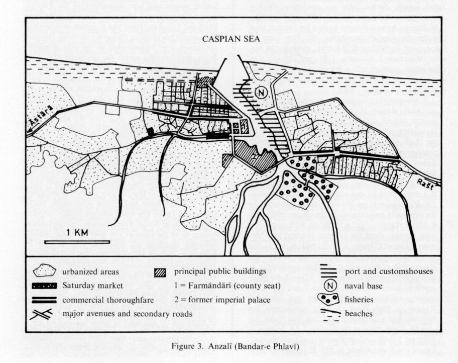
First mentioned at the end of the 9th/15th century, Anzalī is referred to as the port of Rašt by the middle of the 12th/18th century. It is still Iran’s main commercial port on the Caspian Sea. The Russians maintained a trading depot there; in 1805 they set fire to the port upon their return from an expedition against Rašt. The village belonged to the khans of Gaskar and did not become the center of a separate district until the beginning of the 19th century, when it increased in importance and became the main maritime port of entry into Persia. Sailing vessels, and later steamships, of the Russian-owned Caucasus and Mercury Company came from Bākū and Astrakan. These had to anchor in deep water because of a bar blocking the harbor narrows. Travelers and goods were transshipped to the port in smaller boats, then brought across the southeast end of the lagoon to the inner harbor of Pīr Bāzār, which was connected to Rašt by marshy roads. In addition to trade and commerce, fishing was an important activity, and in 1872-73 monopoly rights were granted to the Russian Lianozoff. In 1880 a carriage road was laid between Pīr Bāzār and Rašt; shortly after 1900 the present road, linking Anzalī and Rašt directly by skirting the lagoon to the east, was completed. With the improvement of the roadways, the villages of Anzalī and Ḡāzīān developed into a real town, which Reżā Shah named Bandar-e Pahlavī (until 1979; Figure 3). In order to modernize the port, two jetties were built at the entrance to the harbor and a bridge was built to join the two sections of the town.
The town had 55,000 inhabitants in 1976 and 110,643 in 2006 (Markaz-e Āmār-e Irān), mainly Gilaks and Turks. The latter are mostly emigrants (mohâjer) from Azerbaijan when it was under Soviet rule, and they are particularly numerous in the fisheries and port activities. Anzalī’s principal functions are maritime. One unit of the Iranian navy is based there. As for its commercial traffic, after having remained stationary for a long time (133,000 tons in 1925-26; 126,000 tons in 1951-52), it has shown a marked increase since the 1960s, from 320,000 tons in 1967-68 to 422,000 tons in 1976-77, 1,657,399 tons in 1997-98 and 5,052,198 tons in 2007-08. Imports of Russian industrial products constitute the bulk of the traffic, together with some oil products from Azerbaijân or Kazakhstan. Silk and rice, the leading export commodities of the 19th century, have been replaced by a limited tonnage of wood, stone, and fish. A new Anzali Trade- and Industry Free Zone was opened in 2003.
The Fisheries Corporation (šīlāt) at Ḡāzīān employs more than 2,000 people in management, administration, and research as well as in processing, inventory, quality control, and distribution operations. It handles the entire production of Iranian caviar and sturgeon brought in from forty-eight fishing stations (ṣaydgāh) along the Iranian coast and the catch of the fishing cooperatives. Bus connections with Tehran also made Anzalī the most popular seaside resort in Iran. Ten km of “plāž” (groups of private cabins) and cafés, hotels, and vacation centers line the sandy beach. Anzalī’s inland functions are considerably more modest.
The town serves as the administrative and commercial centre of the small šahrestān of Anzali. It consists of one single baḵš (Markazi, i.e., Central) divided into two dehestān: (1) Čahâr Fariza, named after the four oldest villages, Kolver, Bašman, Sangāčin, and Kopurčāl, includes twenty-one villages to the northwest and southwest of the lagoon. (2) Lijāragi-e Ḥasanābād, with seven villages, lies to the east of Gāziān. The Gilak population (22,491 in 2006) cultivates rice and tobacco, breeds silkworms, fishes and does rattan work. The focus of commercial life is divided between the lively Saturday market, that was formerly linked by boat to the villages around the lagoon, and the modern stores on the town’s major avenues.
Bibliography:
E. Ehlers, “Die Städte des südkaspischen Küstentieflandes,” Die Erde 102/1, 1971, pp. 6-33.
Idem, Iran: Grundzüge einer geographischen Landeskunde, Darmstadt, 1980, pp. 321f.
J. J. Lerch, “Nachricht von der zweiten Reise nach Persien,” Magazin für die neue Historie und Geographie 10, 1776, pp. 434-36, 461.
Markaz-e Āmār-e Irān, Saršomāri-e ʿomumi-e nofus o maskan [decennial national census], Tehran, 1966-2006.
A. Monaco, “L’Azerbeigian persiano,” Bolllettino della Reale Società Geografica Italiana, 1928, pp. 290-92.
Monteith, “Journal of a Tour through Azerdbijan and the Shores of the Caspian,” Journal of the Royal Geographical Society 3, 1833, pp. 21-23.
H.-L. Rabino, “Les provinces caspiennes de la Perse. Le Guilân,” RMM 32, 1915/16, pp. 133-52.
Seidlitz, “Handel und Wandel an der Kaspischen Südküste,” Petermanns Mitteilungen 15, 1869, pp. 255-56.
A. F. Stahl, “Reisen in Zentral- und Westpersien,” ibid., 51, 1905, p. 5.
Col. Trezel, “Notice géographique et statistique sur le Ghilan et le Mazenderan,” Journal des sciences militaires 2, 1826, pp. 121-23.
E. E. ʿArabānī, ed., Rāhnāma-ye Šahrestānhā-ye Īrān, Tehran, 1345 Š./1966, pp. 118-20.
Websites (accessed 30 January 2012).
Anzali Port Authority, at http://anzaliport.pmo.ir/.
Anzali Port Special Economic Zone, at http://www.anzaliport.ir/.
The Mordāb-e Anzalī (also called Mordāb-e Pahlavī or Bandar-e Pahlavī from 1925 to 1979) is located northwest of Gīlān. It was once a gulf of the Caspian sea but was slowly filled in with alluvia brought by streams and torrents from the southern part of the Ṭāleš mountains. The lagoon was finally cut off from the Caspian by a sandbar in the 9th/15th century. In the 19th century, there was considerable navigation in the lagoon, including both transit shipping between Anzalī and the rear harbor of Pīr Bāzār and shipping between villages on the coast. Today, however, the lagoon is no longer navigable, and sedimentation continues to reduce its size: Between 1942 and 1973, its surface area decreased from approximately 145 to 95 square km.
The sandbar running from west-northwest to east-southeast along the north side of the lagoon has two or three rows of dunes 5 to 10 m high. A channel cuts through the middle of the bar between Anzalī and Ḡāzīān. A current usually flows out through the channel to the Caspian because the many streams that empty into the lagoon make its water level slightly higher than that of the sea. In summer when the lagoon is poorly supplied, the current is occasionally reversed as a result of northerly wind pressure, but the more salted sea water (as much as 1.4 percent) does not enter farther than the opening of the channel. Elsewhere the salinity remains lower than 0.1 percent. The shallow fresh water rarely freezes because winters are mild.
In the 1890s as many as 300,000 carp were fished in a day; 1,300 tons were caught in 1935. This heavy fishing in the past has combined with the falling water level to bring about a greatly reduced fish population: Carp (kopūr, Cyprinus carpio) have practically disappeared; Caspian roach (kolma, Rutilus rutilus caspicus), European pike-perch (ūf, Lucioperca lucioperca s. sandra) and bream (sīm, Abramis brama) are found in small quantities, and only sheatfish (esbela, Siluris glanis) and kutum (māhī-e sefīd, Rutilus frisii kutum) are still found in large number, together with goldfish (Carassus auratus), an accidentally introduced fish of low quality. In spite of a slight amelioration brought since 1977 by the return to a tendency to rise in the level of the Caspian Sea, an FAO report (Holčik and Oláh, 1992) recommended to implement remedial measures including hydraulic engineering, an antipollution strategy, and fishery management. In winter, the reed beds and islands of the lagoon still receive one of the most important gatherings of migratory birds in the world. Despite protective measures, there is still some duck hunting, especially with net snares. Large amounts of rushes and reeds are used in making mats (ḥaṣīr) and baskets and to cover the roofs of rural houses. Wet lands in the south and southeast exposed by the withdrawal of the lagoon are employed as good quality grazing land called qoroq.
Bibliography:
J. Holčik and J. Oláh, Fish, Fisheries and Water Quality in Anzali Lagoon and its Watershed. Report to the Islamic Republic of Iran, Rome, FAO, 1992.
Kayhān, Joḡrāfīā II, p. 276.
Razmārā, Farhang II, p. 42.
L. Mofakham-Payan, La baie de Pahlavi (Anzali). Etude Physique, Mašhad, 1347 Š./1968.
E. Amin-Sobhani, “Contribution à l’étude sédimentologique et géochimique des plaines sud de la mer Caspienne,” Thesis, Paris-Orsay, 1972.
E. v. Schüz, Die Vogelwelt des Sud-Kaspischen Tieflandes, Stuttgart, 1959.
(Marcel Bazin)
Originally Published: December 15, 1986
Last Updated: January 1, 2000
This article is available in print.
Vol. II, Fasc. 2, pp. 143-145