


i. IN AFGHANISTAN
Inside Afghan territory a major suture line is the Herat fault which runs from west to east throughout the country over 1,200 km and extends on a further 300 km inside Tajikistan, where it is called the Central Pamir fault. It is actually a dextral (right-lateral) transform fault with a W-E direction west of Čārīkār and a SW-NE direction east of that point. Russian geologists distinguish these two segments by calling them respectively Main Hari Rôd fault (glavnyi gerirudskiiĭ razlom) and Central Badaḵšān fault (Dronov, pp. 465f.). South of it, a network of transform faults delimits several intra-Gondwanan blocks of various sizes. The most important is the S-N Čaman sinistral fault (800 km, out of which 650 km inside Afghanistan), between the Afghan and Indian plates, which is the second major structure of Afghanistan (Wellman). It joins the Herat fault near Čārīkār; from it splay off two secon-dary sinistral faults, the Gardēz fault, which forms the eastern limit of the Kabul block, and the Moqor-Qandahār fault, which is the western limit of the Qalat-e Ḡilzay block (Carbonnel, pp. 145f.). On the other hand, two dextral faults, the NW-SE Sarobī (150 km) and SW-NE Konar faults delimit the Nūrestān and Jalālābād blocks (Prévot, pp. 6, 113).
Present-day Afghan territory is therefore criss-crossed by a network of transform faults of high tectonic activity; hence no surprise if it is a region of high seismic activity. The frequency of detectable earthquakes occurring within, or near, the borders of the country has been assumed to be in the order of 5,000 events per year. Of this large number at least 500 would be classified as significant earthquakes, i.e., earthquakes recorded by seismic stations located outside Afghanistan (Heuckroth and Karim, 1970, p. 4). High as they are, these figures are underestimates, however.
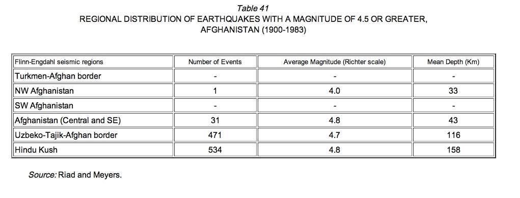
Contemporary data show sharp regional contrasts in the frequency of earthquakes (Table 41; also Schöler and Bauer). Out of 1,039 events with a reported magnitude of 4.5 or greater recorded for the period 1900-1983, 534, or 51.4 percent, occurred in the Hindu Kush region of NE Afghanistan, where a remarkably persistent source of earthquakes is located along the Central Badaḵšān fault in the Kūh-e Ḵᵛāja Moḥammad, between the Warsaj and upper Kōkča valleys, at about 36°30′ N and 70°30′ E—a very isolated and less accessible area; major events originating from that source may cause cracks in buildings in Kabul (250 km SW) and are felt up to distances of more than 1,000 km from the epicenter (e.g., in 1937, 1960, 1962, 1964-65). Another series of 473 major events, or 45.5 percent, were located along the nearby eastern part of the Afghan-Soviet border. But only thirty-two occurred in other parts of the country, including the area of the Čaman fault which thus appears to have been recently less active along its Afghan northern section (the sectio Ḡaznī-Čārīkār being actually inactive; Carbonnel, p. 147) than along its Pakistani southern extremity, where a major shock destroyed Quetta on 31 May 1935, causing a loss of about 30,000 lives (Jackson; Quittmeyer and Jacobs, pp. 793ff.; Yeats et al.; Prévot, pp. 61ff., similarly stresses the low level of microseismic activity south of Moqor. Only one earthquake out of these thirty-two events was recorded in west Afghanistan (the shocks of 19 Sonbola 1310 Š./10 September 1931 and 2 Mīzān 1329 Š./24 September 1950, famous for having reportedly caused the collapse of three minarets in Herat, are not recorded, probably on account of an intensity below 4.5; Figure 31; Ambraseys and Melvill, p. 197, n. 16). The level of modern seismic activity is therefore minimal in western and southern Afghanistan and maximal in NE Afghanistan, in rough accordance with the uneven distribution of transform faults in the country. In the broader Asian context, western and southern Afghanistan are clearly areas of “seismic quiescence” between the much more unstable Persian and Himalayan regions, with NE Afghanistan being definitely included into the latter (Schöler and Bauer; Ambraseys and Melvill, p. 140; Table 41, above).
Average surface-wave magnitudes(measured on the Richter scale) do not show any significant regional variation (Table 41, above). Between 1900 and 1983, however, extreme magnitudes have been recorded only in NE Afghanistan: out of nineteen earthquakes with a magnitude of 7.0 or greater, eighteen occurred in the Hindu Kush and one in the nearby Soviet-Afghan border region. The greatest magnitude recorded has been 8.1 for the 215 km-deep earthquake of 14 Rabīʿ I 1340/15 November 1921 in Kūh-e Ḵᵛāja Moḥammad (Riad and Meyers, p. 115). Somewhat lighter events occurring at smaller depths may be more destructive, however: the Sayḡān-Kahmard earthquake of 19 Jawzā 1335 Š./9 June 1956, located north of the Herat fault, with a magnitude of 7.3 (some reports say 7.6; Quittmeyer and Jacob, p. 796) and a focal depth of only 60 km, caused an estimated 300 to 400 deaths and extensive damage in northern Hazārajāt (Riad and Meyers, map); it was preceded by one foreshock (8 June) and followed by five aftershocks within two days which delineated a rupture zone of some 50 km in length and 25 km in width (Quittmeyer and Jacobs, p. 796).
Sources for Afghan historical seismicity in both archives and published literature still remain to be thoroughly studied. The only available survey lists no more than sixty-two earthquakes from the origin to 1900, and only two between 445/1053 and 1247/1831—an altogether insignificant number (Heuckroth and Karim, 1970, pp. C5ff.). Though preliminary, the present knowledge of historical seismicity in Afghanistan suggests that areas which have been recently free from earthquakes have been badly hit in the past. Such is, for instance, the case for western Afghanistan, where Herat was shocked in 234/849 and again, more severely, in 495/1102 and 765/1364 (Heuckroth and Karim, 1970, pp. 50, C5; Ambraseys and Melville, pp. 37, 41, 44; see idem, p. 140, for excessive downgrading of historical seismicity in western Afghanistan).
The oldest earthquake recorded so far damaged the Greco-Bactrian city of Āy Ḵānom in the period 50 B.C.E.-50 C.E. (Heuckroth and Karim, 1970, pp. 48ff.). In 203/819 a catastrophic earthquake destroyed a quarter of Balḵ and affected the whole area between Fāryāb to Toḵarestān (Ambraseys and Melville, p. 37). The same city was again hit in 813/1410 (idem, p. 44). In 444/1052-53 a destructive earthquake occurred along the Gardēz fault in the Urgūn area (Heuckroth and Karim, 1970, p. 50). Of all the major seismic events in the past, however, the most significant definitely was the Paḡmān earthquake of 3 Ṣafar 911/6 July 1505, located on the northern extremity of the Čaman fault, with an estimated magnitude of 8. Surface faulting was observed and extended for about 60 km along the base of the Paḡmān range where vertical displacements of several meters were recorded. Its effects were felt as far as Agra, a distance of more than 1,000 km, and several aftershocks were perceptible every day during the following month (Bābur-nāma, tr. Beveridge, p. 247; Heuckroth and Amin, 1970, pp. 50f.; Quittmeyer and Jacob, pp. 789f.).
Information is slightly less scanty for the earthquakes of the 19th century. The Badaḵšān seism of 19 Ramażān 1247/21 February 1832 appears to be the first documented earthquake known to have originated from the Hindu Kush; it severely hit the upper Kōkča valley (Heuckroth and Amin, 1970, pp. 51f.). On 8 Moḥarram 1258/19 February 1842 another major earthquake occurred along the Gardēz fault, with maximum intensity in the Alīngār valley and Jalālābād basin; several hundred individuals were killed; the radius of perceptibility of the event was 900 km, and numerous aftershocks were felt for many months (Quittmeyer and Jacob, p. 791). The Jabal Serāj earthquake of 7 Ramażān 1291/18 October 1874 was the third major seismic disturbance of the 19th century. It seems to have been connected with a rupture along the Herat fault, but evidence is not strong (Quittmeyer and Jacob, p. 803). According to some reports, as a result of this earthquake Jabal Serāj, Golbahār, and portions of Kūhestān were completely destroyed, and ground cracks were observed. On 30 Jumādā I 1310/20 December 1892 another severe earthquake was recorded in the Spīn Bōldak border area of southern Afghanistan, along the Čaman fault; left-lateral strike-slip movement of at least 75 cm was observed near the town of Sanzal; it damaged the railway line between Quetta and Čaman; the horizontal extent of the surface faulting was at least 30 km (Griesbach; McMahon, p. 402; Quittmeyer and Jacob, p. 791). According to information gathered by McMahon from local elders, other events had occurred previously—a total of three times during the elders’ life, and similar accounts of repeated movements along the Čaman fault in this vicinity were handed down in oral history.
As one enters the 20th century, information becomes more and more numerous and instrumentally documented (see above). A seismological observatory, equipped with a seismograph, the only one operating in the country, was established in the Faculty of Engineering of Kabul University in 1347 Š./1968 (Heuckroth and Amin 1970, p. 3). Among the significant contemporary events, one may cite the destructive earthquake which leveled most of Paštūn Kōt (Fāryāb province) on 14 Ḥamal 1313 Š./3 April 1934, but caused only little damage in Maymana, less than 10 km away (magnitude 5.4); the Hindu Kush earthquake of 13 Ḥūt 1327 Š./4 March 1949, one of the most severe in the present century (magnitude 7.5, depth 230 km), damaging extensively the entire northeastern part of the country but causing comparatively little loss of life; the Golrān series of light shocks in Asad-Sonbola 1334 Š./August 1955, which destroyed only some houses, stand distinctively among the very few events detected for western Afghanistan; the Saȳḡān-Kahmard earthquake of 1335 Š./1956, already referred to; the Tāšqorḡān (Ḵolm) earthquake of 28 Ḥūt 1355 Š./19 March 1976, located along an offshoot of the Herat fault (magnitude 5.5, depth 33 km), which took the lives of about fifty people and destroyed some 1,200 houses, including the whole village of Saȳḡānčī, which was quickly rebuilt through Australian assistance and according to antiseismic standards (independently supported roof) used for the first time in Afghanistan (Carbonnel and Denizot; Sibtain).
Bibliography
N. N. Ambraseys and C. P. Melville, A History of Persian Earthquakes, Cambridge, 1982.
The Bābur-nāma, tr. A. S. Beveridge, London, 1922, repr. London, 1969.
J.-P. Carbonnel, “La limite de la plaque indienne en Afghanistan. Nouvelles données géologiques et sismologiques,” in Recherches géologiques dans les chaînes alpines de l’Asie du sud-ouest. Livre à la mémoire de Albert F. de Lapparent, Paris, 1977, pp. 145-152.
Idem and F. Denizot, “Le tremblement de terre de Tachkourgan (N. Afghanistan) du 19-20 mars 1976,” Revue de Géormorphologie Dynamique 26/4, 1977, pp. 121-133.
J.-L. Chatelain, Étude fine de la sismicité en zone de collision continentale au moyen d’un réseau portable: Région Pamir-Hindu-Kush, Thèse troisième cycle, Grenoble Univ., 1978.
V. I. Dronov, “Krupneishie razlomy Afganistana,” in Sh. Abdulla and V. M. Chmyrov, eds., Geologiya i poleznye iskopaemye Afganistana, Moscow, 1980, I, pp. 464-73.
E. A. Flinn and E. R. Engdahl, “A Proposed Basis for Geographical and Seismic Regionalization,” Review of Geophysics 3/1, 1965, pp. 123-49.
C. L. Griesbach, “Notes on the Earthquake in Balûchistân on the 20th December 1892,” Records of the Geological Survey of India 26/2, 1893, pp. 57-61.
L. E. Heuckroth and R. A. Karim, Earthquake History. Seismicity and Tectonics of the Regions of Afghanistan, Kabul, 1970.
Idem, “Afghan Seismotectonics,” Philosophical Transactions of the Royal Society of London, A 274, 1973, pp. 389-95.
R. Jackson, Thirty Seconds at Quetta. The Story of an Earthquake, London, 1960.
R. D. Lawrence and R. S. Yeats, “Geological Reconnaissance of the Chaman Fault in Pakistan,” in A. Farah and K. A. De Jong, eds., Geodynamics of Pakistan, Quetta, 1979, pp. 351-57.
A. H. McMahon, “The Southern Borderlands of Afghanistan,” Geographical Journal 9/4, 1897, pp. 393-415.
R. D. Prévot, Sismicité superficielle du nord-est de l’Afghanistan, Thèse troisième cycle, Grenoble Univ., 1979.
R. C. Quittmeyer, A. Farah, and K. H. Jacob, “The Seismicity of Pakistan and its Relation to Surface Faults,” in A. Farah and K. A. De Jong, eds., Geodynamics of Pakistan, Quetta, 1979, pp. 271-84 (covers much of Afghanistan, too).
R. C. Quittmeyer and K. H. Jacob, “Historical and Modern Seismicity of Pakistan, Afghanistan, N.W. India and S.E. Iran,” Bulletin of the Seismological Society of America 69/3, 1979, pp. 773-823.
S. Riad and H. Meyers, Earthquake Catalog for the Middle East Countries 1900-1983, World Data Center A for Solid Earth Geophysics, Report SE-40, Boulder (Col.), National Geophysical Data Center, 1985.
S. Schöler, Aktuelle und historische Seismizität im Vorderen und Mittleren Orient, Wiesbaden, 1992.
Idem and E. Bauer, Vorderer Orient—Seismotektonik, geschichtliche Beben, Wiesbaden, 1984, TAVO Sheet A II 3 (suggestive although coverage is poor for Afghanistan).
S. N. Sibtain, To Build a Village. Earthquake-Resistant Rural Architecture—A Technical Handbook, Sydney, 1982.
H. W. Wellman, “Active Wrench Faults of Iran, Afghanistan, and Pakistan,” Geologische Rundschau 55, 1966, pp. 716-35.
R. Wolfart and H. Wittekindt, Geologie von Afghanistan, Berlin and Stuttgart, 1980.
R. S. Yeats et al., “Surface Effects of the 16 March 1978 Earthquake, Pakistan-Afghanistan Border,” in A. Farah and K. A. De Jong, eds., Geodynamics of Pakistan, Quetta, 1979, pp. 359-61.