

KRŽIŽ, AUGUST KARL (b. Tábor, Bohemia, 12 May 1814; d. Chrudim, Bohemia, 19 January 1886), an Austrian artillery lieutenant hired by Persian government to give instructions at Dār al-Fonun (q.v.) and the military college. Bohemia (Böhmen), or the present Czech Republic, at that time was a state of Austro-Hungarian Empire. Kržiž joined the Austrian Field Artillery in 1832 and advanced through the ranks to first lieutenant in 1851 (Behn, III, p. 317; Egger, p. 309). In 1851, in the reign of Nāṣer-al-Din Shah (r. 1848-96) and at the instigation of the Grand Vizier Mirzā Taqi Khan Amir Kabir (q.v.), a polytechnic school on the European pattern, named Dār al-Fonun (q.v.), was founded in Tehran. To avoid any British and Russian influence on this new institution, Amir Kabir sent Jān (also Žān) Dāwud Khan, the first secretary at the Persian legation in St. Petersburg, to Vienna to employ Austrian experts to serve as teachers at the school and as instructors in the army (Ādamiyat, pp. 356-60; Maḥbubi Ardakāni, I, pp. 256-57, 259-63). Kržiž was one of them. He took an eight-year leave of absence from the Austrian army to serve in Persia from 1851 until 1859. He was knowledgeable in mathematics and natural sciences and showed a genuine interest in the country and its people. Within a short time, he produced textbooks in French for each of his lessons, which were translated into Persian and lithographed for the use of the students (Browne, pp. 154, 157; Storey, p. 22).
Kržiž established a new arms depot, laying the foundation for a modern arsenal for the Persian army. He also constructed the first telegraph line in the country, which connected the Golestān Palace with Lālazār Garden (Bāḡ-e Lālazār), the king’s summer residence outside the capital (Eʿtemād-al-Salṭana, II, p. 550; Maḥbubi Ardakāni, I, pp. 274-75, III, pp. 194-97). All the material and equipment required for this project was made to order in Tehran under his supervision. Nāṣer-al-Din Shah was so delighted that he honored Kržiž with the order of Lion and Sun (Militär Zeitung 11, 1858, p. 322). In 1858, using trigonometric measurement, Kržiž figured out the height of several mountains, including that of Damāvand (q.v.), the highest peak in the country. However, his true pioneering work was the mapping of Tehran and its environs, which will be referred to later. In 1858, he also drew ground plans of the Golestān Palace for the first time. Nāṣer-al-Din Shah elevated Kržiž to the rank of general (sartip), and the Austrian government awarded him the Great Medal for Art and Sciences. When Kržiž returned to his homeland in 1859, he rejoined the Austrian army in his earlier rank of a major, and was given an appointment in Prague. A year later he retired and moved to Chrudim, where he lived for the rest of his life, revisiting Persia a few times. He was married, and his wife joined him during his stay in Persia (Polak, 1876, pp. 18-20; idem, 1877, pp. 218-25; Maḥbubi Ardakāni, I, p. 275; Slaby, 1982, pp. 78-79).
Map of Tehran. Encouraged and supported by ʿAliqoli Mirzā ʿEʿteżād-al-Salṭana (q.v.; d. 1298/1880), the chief director of Dār al-Fonun, Kržiž embarked on a pioneering work to construct a large scale (1: 2880, the Austrian scale of land-registering) “Map of the Capital City Tehran” Tehran (Naqša-ye Dār al-Ḵelāfa-ye Tehrān; Karimiān, pp. 127-28, 218-19; Figure 1). When working on this project, he encountered two major difficulties. Firstly, the complex structure of the city, which had grown without any planning and consisted of countless winding and narrow alleys, presented situations hostile to his undertaking. Secondly, it was not possible for a stranger, and even less for a non-Muslim, to enter any residential quarter and property inhabited by Muslims. Consequently, Kržiž was forced to send two of his Muslim students, Ḏu’l-Faqār Beyg and Moḥammad-Taqi Khan, to survey the residential areas. They were not even allowed to use any tools and instruments, due to the residents’ objection, and distances had to be measured by footsteps at the expense of poor accuracy in delineation (ʿAlāʾi, 2001, pp. 531-32). The task could be pursued and completed only with the help of an edict (farmān) by the imperial court. Kržiž’s map was finally lithographed in Tehran in December 1858 (Jomādā I 1275); its very existence was enough to excite the admiration of Nāṣer-al-Din Shah and his courtiers (ʿAlāʾi, 2001, p. 532; idem, 2005, p. 345; Polak, 1876, p. 1; Slaby, 1977; Dāyerat al-maʿāref-e fārsi I, pp. 696-97, 700-701; Eʿtemād-al-Salṭana, II, p. 699).
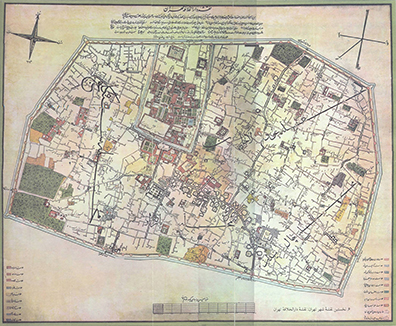
Figure 1. “Map of the Capital City Tehran” by August Kržiž in 1858. Courtesy of Cyrus Alai.
In the 1850s, Teheran covered an area of about 4 km2, of which 280,000 m2 were occupied by the imperial and governmental buildings, called the Arg (q.v.; Ark) quarter, which had its own rampart, moat, and drawbridge. The city wall with six gates, built in 1554 on the order of Shah Ṭahmāsb I Ṣafawi (r. 1524-76), was about 8 km long, with 114 towers equal to the number of the chapters of the Qurʾan (Karimiān, pp. 122-23; ʿAlāʾi, 2001, pp. 532-33). The city had four further quarters: ʿUdlājān, Čāl Meydān, Bāzār, and Sanglaj, each divided into smaller districts. All these features have been clearly shown on the Kržiž’s large (76.5 x 93 cm) and colored map, centred on 35°40′ N and 49°02′ E of Greenwich (inscriptions in Persian). The title and detailed geographical information were placed in the mid-upper part, the scale diagram in the mid-lower, and the legends in both lower corners of the map.
This map remained in use as the only official map of Tehran until a major expansion of the city was ordered by the Nāṣer-al-Din Shah in 1869. The urban expansion was completed in 1874, requiring a new map, which was printed in 1891 (ʿAlāʾi, 2001, p. 534; Karimiān, pp. 222-24; Slaby, 1977).
A “Map of the Environs of Tehran” (Karte der Umgebung von Teheran) inscribed in Persian, was surveyed and drawn by Kržiž and six of his students in 1857-58. It was later corrected and transcribed into German by Jakob Eduard Polak and lithographed on a scale of 1: 108,000 in 1877 in Vienna. The historical and archeological value of this map is worthy of note (Polak, 1877), as it shows the expanded site of the present metropolis of Tehran and beyond. It measures 34 x 38 cm, with Tehran as prime meridian. The old borders and the new wall erected after the expansion of the city in 1874 have been clearly marked. A miniature (size: 18 x 15 cm; scale: 1: 20,700) and simplified version of the Kržiž’s map, entitled “Plan der Residenz Teheran,” appears as an inset in the upper right corner of the sheet (ʿAlāʾi, 2005, p. 347; Polak, 1877).
Publications. During his eight years of service in Iran, besides fulfilling his extensive and demanding official duties, Kržiž used his time to explore the country in depth. He made many journeys to southern, eastern, and northern Persia. As a result, he produced a book titled Reisen nach in und aus dem Oriente, mit Bildern aus Persien. This book was never published, and the manuscript could not be traced by the present author. According to a description of the work in the Militär Zeitung (1861, p. 502), it was written in six chapters: (1) Journey to Persia through Greece, Constantinople and Trabzon, then with caravans…; (2-3) Description of Persia, customs and traditions, feasts, religions, the royal court, public baths, bazaars, climate, vegetations, cities …; (4) Extracts from statistics, geology, art and poetry, sciences of measuring heights, Perso-Arabic astrolabe …; (5) The journeys to Isfahan, Mazandaran, the Caspian Sea, and the volcano Damāvand …; (6) The return journey through the Caspian Sea, Russia, etc. Nonetheless, in 1865 nine extended articles written by Kržiž appeared in the Militär Zeitung (nos. 44-67, 3 June–23 August 1865) in Vienna, with a common title of “Bilder aus Persien,” in addition to nine different sub-titles, which must be an abridged version of his book.
Several other articles by him were mainly published in Austria, including Die Beschreibung … (1866). His textbooks, all translated by Mirzā Zaki Māzandarāni, include: Mizān al-ḥesāb, Tehran, 1857 (375 pp.); ʿElm-e masāḥat, Tehran, 1858 (404 pp.); Ketāb-e ḥesāb bā ʿelm-e handasa, Tehran, 1858; ʿElm-e tup-ḵāna, including maps, Tehran, 1859 (256 pp.); Ketāb dar tašriḥ wa tawżiḥ-e ʿelm-e jar al-aṯqāl, Tehran, 1858. The original versions may be found in the archives of Dar al-Fonun or those of the Persian Army.
Bibliography
Faridun Ādamiyat, Amir Kabir wa Irān, Tehran, 1975, pp. 358-60.
Cyrus Alai (Sirus ʿAlāʾi), “Awwalin naqša-ye rasmi-e Tehrān: bāzgu-ye farhang-e šahri-e Irān dar sada-ye nuzdahom,” Iranshenasi 14/3, 2002, pp. 527-37.
Idem, Special Maps of Persia, Leiden and Boston, 2005.
Wolfgang Behn, Concise Biographical Companion to Index Islamicus: An International Who’s Who in Islamic Studies from Its Beginnings down to the Twentieth Century, 3 vols., Leiden and Boston, 2004-6.
Edward G. Browne, Press and Poetry in Modern Persia, Cambridge, 1914.
Dāyerat al-maʿāref-e fārsi, ed. Ḡolām-Ḥosayn Moṣāḥab, 2 vols., Tehran, 1966-77.
Reiner Egger, “Krziž,” in Österreichisches Biographisches Lexicon IV, Vienna, 1969, p. 309.
Moḥammad-Ḥasan Khan Eʿtemād-al-Salṭana, al-Maʾāṯer wa’l-āṯār, ed. Iraj Afšār with commentaries by Ḥosayn Maḥbubi Ardakāni, as Čehel sāl tāriḵ-e Irān dar dawra-ye pādšāhi-e Nāṣer-al-Din Šāh, 3 vols., Tehran, 1989.
Ḥosayn Karimiān, Tehrān dar goḏašta wa ḥāl, Tehran, 1974.
August Karl Kržiž, Naqša-ye Dār-al-Ḵelāfa-ye Tehrān, Tehran, 1857.
Idem, “Beschreibung, wissenschaftliche Zergliederung und Gebrauchweise des persisch-arabischen Astrolabium,” Archiv für Mathematik und Physik 45, 1866, pp. 289-315.
Ḥosayn Maḥbubi Ardakāni, Tāriḵ-e moʾassasāt-e tamaddoni-e jadid dar Irān, 3 vols., Tehran, 1975-89.
Jacob Eduard Polak, Vorlesungen des orientalischen Museums: Die österreichischen Lehrers in Persien, Vienna, 1876.
Idem, “Topographische Bemerkungen zur Karte der Umgebung und zu dem Plane Tehran,” Mitteilungen der k. k. geographischen Gesellschaft 20, 1877, pp. 218-25.
Jennifer M. Scarce, The Architecture and Decoration of the Gulistan Palace: The Aims and Architecture of Fath ʿAli Shah (1797-1834) and Nasir al-Din Shah (1848-1896),” Iranian Studies 34/1-4, 2001, pp. 103-16.
Helmut Slaby, “Austria i. Relations with Persia,” Encyclopaedia Iranica Online, http://dx.doi.org/10.1163/2330-4804_EIRO_COM_34.
Idem, Bindenschild und Sonnenlöwe: Die Geschichte der österreichisch-iranischen Beziehungen bis zur Gegenwart, Graz, 1982; new ed., ed. Bert G. Fragner, Vienna, 2010.
Idem, ed., Plan von Teheran/Map of Teheran: Aufgenommen von/Drawn by August Kržiž, Graz, 1977. C. A. Storey, Persian Literature: A Bio-Bibliographical Survey II/1, London, 1927.