

KERMANSHAH
i. Geography
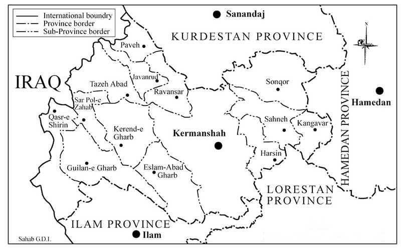
Physical geography. Kermanshah Province, situated in western Iran, spreads over an area of 25,000 km2 (9,560 square miles, roughly the size of Vermont), or 1.5 percent of the total area of the country (Figure 1). It lies between lat 45.5° and 48° E, long 33.7° and 35.3° N (parallels that cut across the Mediterranean Sea and southern United States).
Most of the surface of the province lies within the Zagros chain, which forms the western periphery of the Iranian Plateau. Running from southeast to northwest, the nearly parallel broken ridges of the Zagros are highest in the east of the province, and elevation drops progressively towards the west, until the vast plains of Iraq fill the horizon. One chain that stands prominently on Kermanshah’s map is Parrow, stretching 62 km southeast up to the famous Mt. Bisotun, with the summit Sheikh ʿAli Khan (3,257 m) overlooking the city of Kermanshah. Standing tallest in the province is Mt. Dālāḵāni, with summit at 3,350 m, separating Sonqor and Kangāvar in the northeast of the province. The average elevation is about 1,800 m in the northern and eastern parts of the province (Google Earth; WD, 2000, pp. 323-51; Jaʿfari, I, pp. 131, 244).
Cutting through the mountains there are fertile valleys of various breadths formed by rivers. The major rivers of the province form the upper tributaries of the Karḵa River). The longest one is the Gāmāsiāb (or Gāmāsb), which originates from Mt. Alvand and flows through the valleys in Kangāvar and Ṣaḥna, before it receives the Dinavar river as confluent (cf. Jaʿfari, II, p. 416). Further downstream it joins the southerly flowing Qarasu just after the latter leaves the city of Kermanshah. From this point the river, now called Seymara, takes a meander path below lofty cliffs to join the mighty Karḵa in Khuzestan. In the west of the province there are lesser rivers that discharge into the lowlands of eastern Iraq (WD, 2000, pp. 60-72; Google Earth).
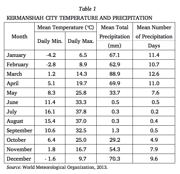
The climate of the highlands is mild in summer and cold in winter, with heavy snowfall; only the province’s western strip belongs to the warm climate (garmsir; see CLIMATE). The average temperatures in Kermanshah City are approximately 0° C in January and 26° C in July (WAP, p. 394; cf. Ganji, p. 247; for details, see Table 1). The winds blowing from the Mediterranean Sea carry rainclouds, with an annual precipitation of up to 70 cm in the highlands and about 40 cm at Kermanshah City—roughly twice the rainfall in Tehran (WD, 2000, pp. 25-27; see Table 1 for details). Native trees include elm, oak, sycamore, and conifers in the highland, and planes, willows, and poplars on the plains. Foothills and plains used to be covered by forest of shrubs and trees, especially in the south of the province. The forests, however, have shrunk considerably, from an estimated original of 800,000 ha, as a result of human intervention (cf. WD, 2002, pp. 74-84; see also FORESTS AND FORESTRY). Kermanshah was known to have a rich wildlife of deer, wild goats and sheep, boars, leopards, and foxes, but much of the native fauna survives only in the memory of aged hunters. Birds on the other hand seem to have had better chance of survival (cf. WAP, I, p. 399; WD, 2002, pp. 88-89).
Political geography. The province is bound on the south by Ilām Province, on the southeast by Lorestān Province, on the east by Hamadān Province, on the north by Kordestān Province, and on the west by Iraq, with about 250 km of international borderline.
The provincial boundaries have been subjected to several major alterations in the past century. Under the later Qajars, when Persia was divided into four major provinces (eyālat) and twenty-three smaller ones (welāyat), Kermanshah was one of the latter units (Wadiʿi, p. 245; cf. Lambton, p. 168). This arrangement was perpetuated into the Pahlavi era, when the country was still divided into twenty-seven parts (qesmat; Kayhān, II, pp. 136-37), of which Kermānšāhān, roughly matching the current province, comprised the following districts: Kermanshah and Ḥuma; Sonqor and Kolyāʾi; Miān Darband, Bālā Darband, and Zir Darband; Dinavar; Kangāvar; Māhidašt, Hārunābād and Firuzābād; Ṣaḥna; Kerend; Ḏohāb and Qaṣr-e Širin; Harsin (Kayhān, II, pp. 451-52). The administrative reforms of 1937 that divided Persia into ten provinces (ostān), made Kermanshah City the capital of Fifth Province (Ostān-e Panjom), which embraced what was then known as Kermānšāhān proper but also Šāhābād, Sanandaj, Malāyer, Hamadān, and Ilām (Wadiʿi, pp. 247, 252; Razmārā, p. 359; Moṣāḥab, I, p. 122). In the following decades the territory of Fifth Province was fragmented into the province of Kermānšāhān and the minor provinces (farmāndāri-e koll) of Kordestān, Hamadān, and Ilām, all of which were consolidated into full provinces (ostān) in the early 1970s.
Soon after its establishment in 1979, the Islamic Republic followed a strategy of erasing the collective memory of imperial Persia, and as a consequence it targeted the toponyms with the component šāh (king). Šāhābād thus became Eslāmābād, Naft-e Šāh became Naft-e Šahr, and Kermānšāh became Imān-šahr, then Qahramān-šahr. Soon after, the names of both Kermānšāhān Province and its capital city Kermānšāh were consolidated to Bāḵtarān (for details, see ṬATARI), presumably a plural or genitive form of bāḵtar (west). As the name Bāḵtarān failed to gain popularity outside official usage, the regime finally gave up in the early 1990s by reinstating the historical name of the city and of the province (as Kermānšāh, without the suffix -ān).
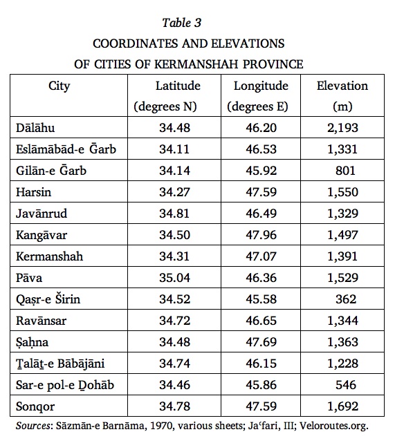
The administrative subdivisions of the province have also seen profound changes over the decades. In the early 20th century there were eight divisions within the present territory of the province: Kermānšāhān, Kangāvar, Harsin, Ṣaḥna (in Kermānšāhān Sub-province), Šāhābād, Kerend, Qaṣr-e Širin, Eyvān (in Šāhābād Sub-province; Wadiʿi, p. 252). In the 1960s and 1970s, the province was organized into five šahrestāns (sub-provinces or counties): Sonqor, Kermanshah, Pāva, Šāhābād-e Ḡarb, and Qaṣr-e Širin (Sāzmān-e Barnāma, 1970; idem, 1981). By the 2000s, the sub-provinces had grown to eleven in number; from the northeast, they were Sonqor, Kangāvar, Ṣaḥna, Harsin, Kermanshah, Javānrud, Pāva, Eslāmābād-e Ḡarb, Gilān-e Ḡarb, Sar-e Pol-e Ḏohāb, and Qaṣr-e Širin (Jaʿfari, III, p. lviv). The most recent additions are Dālāhu, Ravānsar, and Ṯalāṯ-e Bābājāni sub-provinces. Similarly, the number of districts within each sub-province has grown in a proportional manner. For the sub-provinces and their administrative centers, see Table 2 and Table 3.
Human geography. The City of Kermanshah (lat 34.31° N, long 47.07° E, avg. elev. 1,391 m) is the capital of Kermanshah Province and the principal city of western Iran. As such, the city functions in reality as a bureaucratic center of the whole region, beyond provincial boundaries. Kermanshah began to undergo significant urban and economic development following World War II. Its demography discloses a growth of more than sixfold within half a century, from 125,000 souls in 1956 to nearly 800,000 in 2006 (see below, iii)—its growth thus following an S-curve, with its inflection point (the level where rate of increase flattens) corresponding to the 1980s. This growth, however enormous it sounds, is proportionate to the national average and therefore explains the steady position of Kermanshah among major Iranian cities: it ranked seventh in 1900, eighth in 1976, and ninth in 2006, remaining among the second-rank provincial centers such as Ahvāz and Rasht (see also CITIES iv. MODERN URBANIZATION AND MODERNIZATION IN PERSIA). An outstanding fact is Kermanshah’s bilingualism in Persian and Kurdish (Hourcade et al., pp. 60 ff.), but the fact that the townspeople are Shiʿite may explain Kermanshah’s far lower level of ethnic strife compared with other major Kurdish-speaking nuclei such as Sanandaj and Mahābād.
Much of the industrial activities of the province is concentrated in its capital city. An early modern industrial enterprise, established in 1962, is the Bisotun sugar-refining factory. As the factory proved to be interacting very well with the agricultural sector, another sugar factory was established in Šāhābād (WD, 2002, p. 247). There are also several operative factories of medium size that manufacture textiles for local consumption. Other industries include food processing, electrical and mechanical appliances, and cement and construction materials, as well as mining of marble and limestone throughout the province (WD, 2002, pp. 279-85); the most notable enterprise of all is Kermanshah’s oil refinery, which was completed in 1971. In the same year, a suburban industrial town was established in conjunction with the ambitious development plans of the time. This strategy, however, remained largely unrealized, partly as a consequence of the eight-year war of attrition between Iran and Iraq, which affected Kermanshah far more severely than most other urban centers in Iran. Overall, the industrial development of the city and province has been assessed unsatisfactory by the local officials (WD, 2002, pp. 242 ff.).
The chief heavy industry of the province is petroleum. The Naft-e Šāh oilfield near Qaṣr-e Širin is part of an oil reservoir that extends across the international border with Iraq. One of the first discovered in Iran (1927), Naft-e Šāh’s oil began to be pumped through a pipeline to a small refinery built in Kermanshah in 1936. Commensurate with the expansion of the oilfield, a new refinery was built in Kermanshah, as stated above. Built with a daily capacity of 30,000 barrels, the refinery produces much of the petroleum products consumed in western Iran (WD, 2002, pp. 286-90; Clarke and Clarke, pp. 64-67; Bémont, II, pp. 181-82; see also OIL INDUSTRY ii).
The rural economy has remained the backbone of the province’s livelihood. Adequate rainfall and fertile soil have made Kermanshah one of the major agricultural areas of the country. The vast alluvial plains of Māhidašt, Bisotun, Harsin, Kerend, Čamčamāl, and Ṣaḥna, among others, constitute nearly one-third of the province’s area. Of an estimated 820,000 hectares of cultivable land, more than 80 percent is subject to dry farming. The rivers are the main source of irrigation, and while subterranean channels (kāriz) are also dug, they play a far lesser role in Kermanshah’s agriculture when compared to the inner parts of the Iranian Plateau. A typical rural landscape is wheat and barley fields. Beetroots are also harvested in abundance, and beans, potatoes, vegetables, alfalfa, and fodder are farmed in most valleys. Horticulture is rich, producing grapes, in which Kermanshah excels, and apples in substantial quantity to export. Family-size farming dominates the rural economy of the province, while agronomic industry, which was interrupted by the Iran-Iraq War (see IRAQ vii. IRAN-IRAQ WAR), is on the rise once more (WD, 2002, pp. 218-31; Afšār, I, pp. 150 ff., II, pp. 1440-45; Solṭāni, pp. 105-12).
The historical nomadic background of the province is justified by the existence of rich highland pastures that supported livestock raising and pastoralism. The ghee produced in the province (rowḡan-e kermānšāhi) is celebrated nationwide. Nevertheless, as overgrazing has brought much destruction to flora, animal husbandry is now practiced mostly by agriculturalists (see also DĀM-DĀRI), who keep sheep and goat (2.7 million heads) and cattle (1.4 million) for meat and milk production. Most farms raise poultry, and beekeeping and fish farming are practiced in some districts. The rural economy is further enhanced by cottage industries such as kilim and carpet weaving (see CARPETS), cotton-shoe making (see GIVA), and woodwork and metalwork (WD, 2002, pp. 234-40; Afšār, II, pp. 1445 ff.; Solṭāni, pp. 123-24).
Owing to its position as the last outpost on the artery that links the Iranian Plateau to Mesopotamia, Kermanshah has benefited from transit throughout history. The interruption of mercantile shipment during chilly relations between Iran and Iraq under the Baʿṯ regime (see IRAQ vi) came to an end following the Iraq War (2003-11), so that Qaṣr-e Širin has once again become a major commercial border town of Iran. A railway traversing the province is projected to link the rail networks of the two neighboring nations. Resumed also are caravans of pilgrims passing through the province on their way to the holy Shiʿite shrines of Najaf and Karbalā in Iraq (see ʿATABĀT). What is more, with the improvement of highways and expansion of Kermanshah airport, the city has broadened its share of domestic tourism. The main attractions near the city of Kermanshah are ancient Bisotun and Ṭāq-e Bostān (see SASANIAN ROCK RELIEFS), whose very construction was probably intended to display the splendor of the Persian empires to ancient passing travelers.
Bibliography:
Ludwig W. Adamec, Historical Gazetteer of Iran I, Graz, 1976, pp. 353-76.
Iraj Afšār Sistāni, Kermānšāhān o tamaddon-e dirina-ye ān, 2 vols., 2nd ed., Tehran, 2002.
ʿAziz-Allāh Bayāt, Joḡrāfiā-ye moḵtaṣar-e Kermānšāh, n. p., 1957.
Frédy Bémont, Les Villes de l'Iran, des cités d’autrefois à l’urbanisme contemporain, 3 vols., Paris, 1969-77.
John I. Clarke and Brian D. Clarke, Kermanshah: An Iranian Provincial City, Durham University, Department of Geography Papers, series no. 10, 1969.
ʿAbd-al-Reżā Faraji et al., Joḡrāfiā-ye kāmel-e Irān, 2 vols., Tehran1987, I, pp. 388-417.
Moḥammad-Ḥasan Ganji, “Climate,” in William B. Fisher, ed., Cambridge History of Iran I: The Land of Iran, Cambridge, 1968, pp. 212-49.
Gitā-šenāsi Institute, Aṭlas-e rāhhā-ye Irān, Tehran, 2007.
ʿAbd-al-Rafiʿ Ḥaqiqat, Farhang-e tāriḵi o joḡrāfiāʾi-e šahrestānhā-ye Irān, Tehran, 1997, pp. 245 ff.
Bernard Hourcade et al., Atlas d’Iran, Paris, 1998.
ʿAbbās Jaʿfari, Gitā-šenāsi-e Irān, 3 vols., 3rd ed., Tehran, 2005.
Masʿud Kayhān, Joḡrāfiā-ye mofaṣṣal-e Irān, 3 vols., Tehran, 1931-32.
Ann K. S. Lambton, “Kirmānshāh,” in EI2 V, 1986, pp. 167-71.
Laurence Lockhart, Persian Cities, London, 1960.
Ḡolām-Ḥosayn Moṣāḥab, ed., Dāyerat al-maʿāref-e fārsi, 2 vols., Tehran, 1966-77.
Google Earth, at google.com/earth (accessed 14 December 2013).
Hayacinth Louis Rabino, Gazetteer of Kirmanšah, Simla, 1907.
Idem, “Kermanshah,” Revue du monde musulman 38, 1920, pp. 1-40.
Ḥosayn-ʿAli Razmārā, ed., Farhang-e joḡrāfiāʾi-e Irān (ābādihā) V: ostān-e 5. Kordestān: šahrestānhā-ye Ilām, Bijār, Tuyserkān, Saqqez, Sanandaj, Šāhābād, Qaṣr-e Širin, Kermānšāh, Malāyer, Nehāvand, Hamadān, Tehran, 1952.
Sāzmān-e Barnāma wa Budja: Markaz-e Āmār-e Irān, Village Gazetteer: farhang-e ābādihā-ye kešvar XIX: ostān-e Kermānšāhān: Šahrestānhā-ye Pāva, Sonqor, Šāhābād-e Ḡarb, Qaṣr-e Širin, Kermānšāh, bar asās-e natāyej-e saršomāri-e ʿomumi-e Ābān-māh-e 1345, Tehran, 1970.
Idem, Saršomāri-e ʿomumi-e nofus o maskan: Ābān-e 1355, Tehran, 1981.
Sāzmān-e Fār, Rāhnemā-ye šahrestānhā-ye Irān barāye mohandesin-e mošāwer ..., ed. Ebrāhim Eṣlāh ʿArabāni, Tehran, 1967, pp. 250-67.
Moḥammad-ʿAli Solṭāni, Joḡrafiā-ye tāriḵi o tāriḵ-e mofaṣṣal-e Kermānšāhān I, 2002.
ʿAli Ṭaṭari, “Az ‘Kermānšāh’ tā Kermānšāh [sic]: goftogu bā ʿAli-e Ṭaṭari,” Goftogu, serial no. 61, Esfand 1391 Š./ March 2013, pp. 101-16.
Velorus.org, at http://veloroutes.org/elevation/?location=kermanshah%2C+iran&units=e (accessed 27 October 2013).
Kāẓem Wadiʿi, “Edāra va taqsimāt-e kešvari-e Irān,” Barrasihā-ye tāriḵi 4/2-3, 1969, pp. 233-54.
[WAP] Wezārat-e Āmuzeš o Parvareš, Joḡrāfiā-ye kāmel-e Irān, 2 vols., Tehran, 1987.
[WD] Wezārat-e Defāʿ: Sāzmān-e joḡrāfiāʾi, Farhang-e joḡrāfiāʾi-e kuhhā-ye kešvar II: Markazi, Eṣfahān, Lorestān, Kermānšāh, Ilām, Baḵtiāri, Ḵuzestān, Tehran, 2000.
Idem, Farhang-e joḡrāfiāʾi-e šahrestānhā-ye kešvar (Šahrestān-e Kermānšāh), Tehran, 2002.
World Meteorological Organization, “World Weather Information Service – Kermanshah” (in Persian), at http://worldweather.met.gov.om:8000/114/c01452f.htm (accessed 15 December 2013).
(Habib Borjian)
Originally Published: August 19, 2014
Last Updated: April 18, 2016
Cite this entry:Habib Borjian, "KERMANSHAH i. Geography," Encyclopædia Iranica, online edition, 2014, available at http://www.iranicaonline.org/articles/kermanshah-01-geography-archived (accessed on 19 August 2014).