

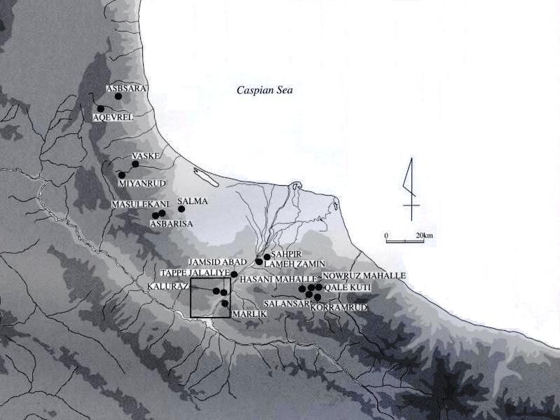
KALURAZ, an archeological site (lat 36°54′ N, long 49°28′ E) situated in the center of the lower Kaluraz valley (Darra Kaluraz) near Jalaliye (Jalāliya) village, 1.1 km west of Rostam Ābād city, 11.7 km northeast of Rudbār in Gilan Province (Figure 5). Marlik, one of the most important Iranian archeological sites, which dates to the early Iron Age of the late 2nd millenium BCE, is located to the east, on the other side of the Sefidrud river. Beyond Marlik, on the other side of Mt. Dorfak (Kuh-e Dorfak, 2,703 m), is Dailaman (see DEYLAMĀN), another important archeological region of Gilan. Many ancient sites are distributed around the Kaluraz site; the surrounding hillside and valley are especially crowded with very many ancient graves. Thus Kaluraz is one of a number of groups of ruins that contribute to the high density of ancient sites in this area (Figure 6).
The Kaluraz site. The site of Kaluraz was excavated by Ali Hakemi (1915–1997) of the Irān Bāstān Museum from 1965 to 1968 (Hakemi, 1973) and in 1967, 1968, and 1969 (Hakemi, 1968; “Kaluraz,” 1969, 1970). According to the results of these investigations, the Kaluraz site consisted of groups of tombs or necropoles “of either the eighth-seventh centuries B.C. or the third century B.C. Of particular interest are more than a dozen handsome bronze animal figurines from the eighth-seventh century graves, each with a uniform, highly stylized design not exactly matched elsewhere” (“Kaluraz,” 1969; see figures, Hakemi, 1968, pp. 80-81; idem, 1973, pp. 4-7). Skeletal remains and horse burials were found, the latter inviting comparison with those at Marlik (on which, see Negahban, 1996, I, p. 305). Hakemi's discussion (1973) of the Kaluraz site connected it with the ancient tribe of the Mardi who are associated with the region in Classical sources (see ĀMOL i; see also Negahban, 1996, I, p. 321). A more recent theory assigns the place to the Cadusii (q.v.), neighbors of the Mardi (reported online; see “Kadusi,” quoting M. R. Ḵalʿatbari of the Archeological Research Center).
The excavator reported features that looked like building structures: “stone foundations of several buildings” (1968) or “remains of stone walls” (1973). Regrettably, there are not detailed descriptions indicating the scale of the structures, nor is any chronological relationship determined with tomb constructions or other building structures at Marlik or Dailaman. Also, the specific find spots on the site of the various artifacts are not clearly specified. Thus more recent reports (personal communication) of accidental finds of ancient tombs and horse burials of the same style as those from “Kaluraz site” may indicate that the original finds came from a more dispersed area than the 1960s excavation site. The question of the degree of shared characteristics between the Kaluraz and Marlik artifacts and horse burials remains to be be resolved.
Almost all the objects excavated by Hakemi are now kept in Iran National Museum (Tehran). They are exhibited and open to the public. Since they had been archeologically reported only with photographs, in 2005 Japan-Iran joint researchers carried out new archeological studies for about 50 objects from the Kaluraz site.
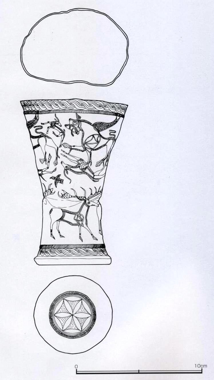
A gold cup (Figure 1) from Kaluraz is worthy of attention. It is cylindrical and 13.0 cm in height, and engraved metal designs cover the whole exterior. A geometric rosette pattern decorates the bottom, and the side is ringed at top and bottom with a guilloche pattern and a linear band. The intervening space is divided into two registers, both with animal designs. In the space of the upper register are four figures of a winged lion that attacks a gazelle, an attacked gazelle, and a gazelle escaping. In the space of the lower register, there are three figures of a deer and a bird. Such a type of gold cup has been excavated also from the ruins of Hasanlu (q.v.) and Marlik, and is one of the characteristic remains of the Iran Iron Age.
A unique object found at the Kaluraz site is a male figurine attached to, and shown grasping, a multiple (seven-part) earthenware vase with a beak-shaped spout at the opposite end (Figure 2). It is about 35 cm in length and 14.5 cm in height. The containers and the spout are hollow and connected to circulate and pour the liquid contents. Such a vessel is called a “Kernos Ring” and is distributed, in various forms, throughout West Asia (Shikaku, 2003). The Kaluraz example is important in showing the eastward extension in distribution of this type of vessel.
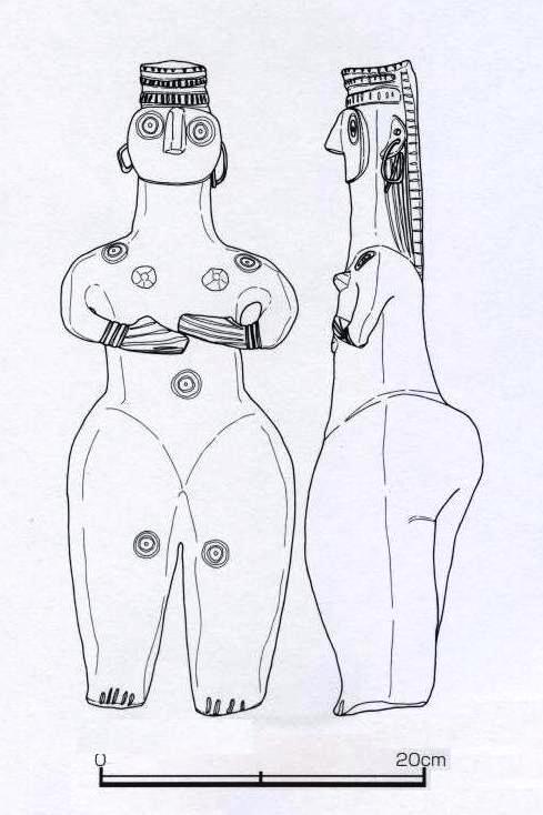
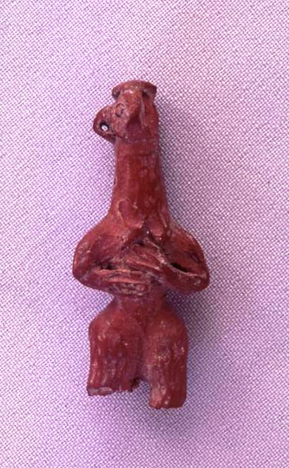
Another notable artifact is a female figurine (Figure 3), which has the same characteristics as a small female figurine excavated from nearby Tappe Jalaliye (Figure 4); the two are discussed below.
The Jalaliye sites. In 2001, the research mission from the Middle Eastern Culture Center in Japan headed by T. Ohtsu performed a general survey in the Kaluraz area. They divided the site, formerly called simply “Kaluraz,” into three parts—Jalaliye A, Jalaliye B and Jalaliye C—and so reported the site under the names “Kaluraz, Jalaliye A, B, C” (Ohtsu, 2003).
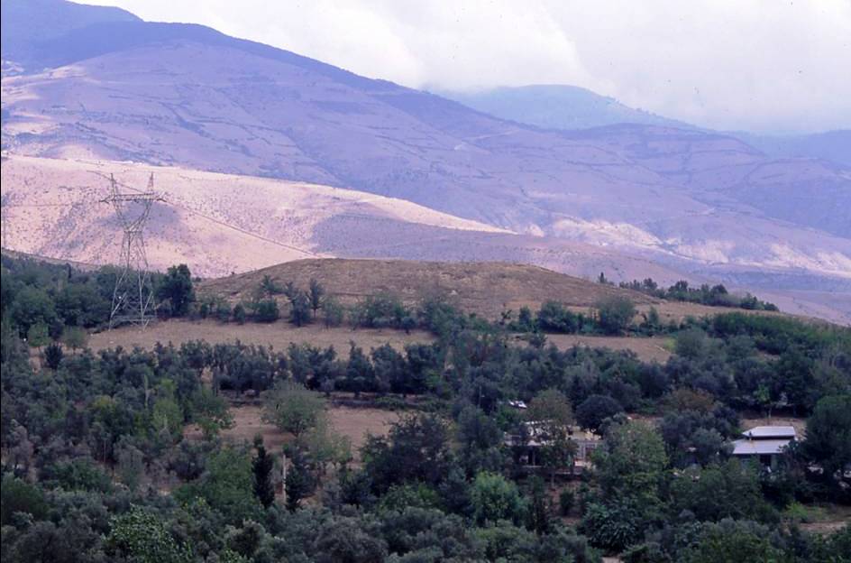
Kaluraz Jalaliye A is a tappe (Tappe Jalaliye; Figure 7) situated in the center of the lower Kaluraz valley on the northwest side of Jalaliye village and the old Tehran-Rasht road. The shape of the bottom of the site is oval, and the measurements of this mound are 150 m from east to west by 80 m from north to south. It rises to a height of 15 m. Its top forms a large flat place; the view from there shows an ovoid shape gradually contracting to the east. The Gilan earthquake in 1990 destroyed the modern buildings that had been built on the top. The tappe is densely surrounded by groves of olive, pomegranate, walnut, and other trees, which contrast with the bare, treeless mound. The results of excavation of Kaluraz Jalaliye A are described in detail below.
Kaluraz Jalaliye B is an ancient graveyard located along the steep slope on the southeastern side of the tappe Kaluraz Jalaliye A. There are some potsherds on the surface. The graveyard extends to the old Tehran-Rasht road, where M. R. Ḵalʿatbari carried out excavations in 1991 after the Gilan earthquake (Ḵalʿatbari, 1997).
Kaluraz Jalaliye C is located on the easy slope on the southern side of the Tepe Kaluraz Jalaliye A. There are plenty of potsherds on the surface, which belong to the pre-Islamic period. Kaluraz Jalaliye C includes the Lower Paleolithic site Ganj Par (see Figure 2 map, above), where Hakemi carried out excavation in 1968 (see now Biglari and Shidrang). The site Kafarkash, an ancient graveyard on the south bank of the Kaluraz river, is now used as an orchard; it seems to include “Daghdaghan” (on the Figure 2 map), where Hakemi carried out excavation in 1968.
Kaluraz Jalaliye A: results of excavation research at Tappe Jalaliye. According to the results of excavating one research trench of 2.5 m × 30 m during 2001and 2004, Tappe Jalaliye has three cultural layers under the surface of its mound: L-I, L-II, and L-III (sequenced from the top).
From L-I, a wall structure built with mud bricks and stone blocks was unearthed. This wall had been partially destroyed by a hole dug perpendicularly through it, and from this hole pottery shards of a cooking pot with lid and a painted pot and dish of the Parthian/Sasanian period were recovered. The presence of thick sedimentary layers of ashes can be understood as the trace of long-term, continuous habitation during the L-I period.
L-II and L-III are clearly divided by a sedimentary layer regarded as a building floor, but the remains from both of these cultural layers, especially pottery shards, show the characteristics of Iran Iron Age. Since almost all the pottery fragments are very small, it is quite difficult to specify the vessel forms. However, characteristic pottery remains include fragments of black burnished pottery, which have gloss just like a metal object, incised pottery, and a neck fragment of a beak-spouted vessel.
If L-II and L-III are compared with the remains from Dailaman researched by Japanese missions or the remains from Marlik found by Negahban before the Islamic Revolution, their archeological chronology is dated back to the Iran Iron Age III (ca. 9th-7th cents. BCE). According to the pottery analysis (Adachi, 2005), vessel shapes which resembled the materials from L-II and L-III were unearthed from the upper layer of Ghalekuti AV grave, the BIII grave, the upper layer of the CI grave (Egami et al., 1965), and the Marlik graves nos. 2, 13, 26, and 41 (Negahban, 1966).
This archeological dating coincides generally with the data of 14C dating. The measurement values of charcoal samples from L-III—2439±28 BP (NUTA2-6212), 2553±32 BP (NUTA2-5760), 2505±28 BP (NUTA2-6215)—correspond to calibrated ages between the early 8th century BCE and late 5th century BCE. From L-III, small iron fragments were found. They are wrought iron produced by a low-temperature reduction direct steelmaking method.
One of the interesting objects is a small female figurine excavated from Tappe Jalaliye L-III during the fourth season, 2004 (Figure 4). To say nothing of the whole form of it, the expression of the head, especially the style of its back hair tied up into a knot, closely resembles that found from Kaluraz (Figure 3), suggesting a high probability that both figurines were made in the same period. Although it was already known that female figurines of such type were excavated from Kaluraz and some other sites in Gilan province, the exact period they belong to was not clear. Since the female figurine was excavated from the L-III of Tappe Jalaliye, one of the investigation results is that figurines of such type are proved to be of ca. 9th-7th centuries BCE.
The character of the excavated building ruins cannot be specified with certainty, because the excavation range was too narrow.
Bibliography:
T. Adachi, “The Iron Age Pottery from Tappe Jalaliye, Layer II, III,” in Ohtsu et al., eds., 2005, pp. 69-74.
F. Biglari and S. Shidrang, “The Lower Paleolithic Occupation of Iran,” Near Eastern Archaeology 69/3–4, 2006, pp. 160-68.
N. Egami, S. Fukai, and S. Masuda, Dailaman I. The Excavations at Ghalekiti and Lasulkan 1960, Institute for Oriental Culture, University of Tokyo, Tokyo, 1965.
A. Hakemi, “Kaluraz and the Civilization of the Mardes,” Archaeologia Viva 1/1, 1968, pp. 63-66.
Idem, “Excavations in Kaluraz, Gilan,” Bulletin of the Asia Institute of the Pahlavi University 3, 1973, pp. 1-3.
“Kadusi”: “Kadusi Governmental Citadel Discovered in Gilan,” at website “Latest archaeological news from Iran,” http://iranarch.blogspot.com/2006/01/ kadusi-governmental-citadel-discovered.html, 16 January 2006.
M. R. Ḵalʿatbari, “Kāvoš dar Kaluraz,” in Yādnāma-ye gerdhama’i-ye bāstānšenāsi-ye šuš, Tehran, 1376 Š./1997, pp. 89-126.
“Kaluraz” in “Survey of Excavations in Iran, 1967-8,” IRAN 7, 1969, p. 181.
“Kaluraz” in “Survey of Excavations in Iran during 1968-69,” IRAN 8, 1970, p. 183.
E. O. Negahban, Marlik: The Complete Excavation Report, 2 vols., University Museum, University of Pennsylvania, Philadelphia, 1996.
T. Ohtsu, Archaeological Survey in Northwestern Iran – Report on the General Survey in Gilan and Its Surrounding Areas, Middle Eastern Culture Center in Japan (MECCJ), Tokyo, 2003.
Idem, “AMS Radiocarbon Measurement of the Samples from Tappe Jalaliye,” in Ohtsu et al., eds., 2004b, pp. 93-94.
T. Ohtsu, K. Yamauchi, and J. Nokandeh, eds., Preliminary Report of the Iran Japan Joint Archaeological Expedition to Gilan, First Season, 2001, Iranian Cultural Heritage Organization and MECCJ, Tokyo, 2003; Second Season, 2002, Tokyo, 2004a; Third Season, Tokyo, 2004b; Fourth Season, Tokyo, 2005; Fifth Season, Tokyo, 2006.
R. Shikaku, “The origin and diffusion of Iron Age kernos rings” (in Japanese), Journal of West Asian Archaeology [Nishi ajia kōkogaku] 4, 2003, pp. 77- 86.
(TADAHIKO OHTSU)
Originally Published: December 15, 2010
Last Updated: April 20, 2012
This article is available in print.
Vol. XV, Fasc. 4, pp. 409-412
The_Pleistocene_Human_Settlement_in_Gilan_Southwest_Caspian_Sea_Recent_Research_Eurasian_Prehistory_8_1-2_3-28.