


KALĀT-E NĀDERI (lat 37°00′05′′ N, long 59°45′27′′ E), an elevated, isolated plateau in the mountains of Khorasan, some 150 km north of Mašhad, edged with steep cliffs that transform it into an almost inaccessible natural fortress. Geologically, it is in a synclinal enclave, thrust into relief by differential erosion of the Upper Cretaceous sedimentary series. Basically oval in overall shape, over 30 km long with an average width of 8 to 12 km, it reaches heights of some 900 to 1100 meters at the high points of the edges, which dominate the outer flanks with continuous sheer hard limestone cliff walls rising 100 to 200 meters above a talus of soft rock formed in the surrounding subsurface. Only two main approaches provide access to the interior, one called Arḡavān (Arḡun) to the southwest, and one called Naftā to the northeast. They are linked by the presence of a superimposed river, flowing northeast, which crosses the syncline from one side to the other and has carved a valley through the heart of the fortress, 350 to 500 meters deep, and of varying width, in the soft rock underlying the limestone. These geological conditions yield good arable soil between the grassy plains of the banks. Three secondary approaches, to the southeast, west, and northeast, accommodate very narrow, difficult mule paths, negotiable only in single file. There are a few tracks for shepherds and goats, which are nearly impossible to traverse in some places without resorting to using hands.
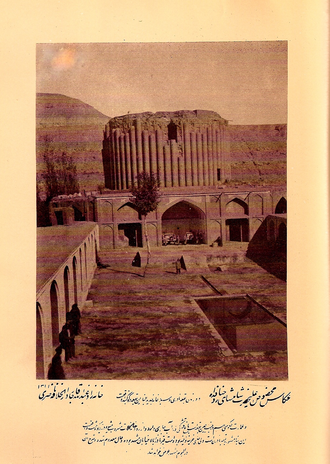
Such an unusually high place, and its defensive value, did not fail to be exploited from very early on. Several references to kalāt in the tragic episode of the young Forud in Ferdowsi’s Šāh-nāma (ed. Khaleghi-Motlagh, III, pp. 27-99) are thought to refer to this location (Sykes, pp. 570-72). Its earliest mention in historical accounts comes from the Mongol period, when the fourth Il-khan of Iran, Arḡun Khan (q.v.; 1284–91), who sought refuge there after being defeated by his uncle Aḥmad Takudār (q.v.), built a defensive work at the south approach that still bears his name (“Gate of Arḡun”). The inscription, carved on a cliff nearby, was wrongly attributed by British travelers at the end of the 19th century to the time of Arḡun. As Sir Percy Sykes pointed out, it belongs to a much later date and “was chiselled in the honour of the great Afshár” (Sykes, p. 574). It is a Turkic inscription apart from a few lines of verse in Persian, and as Sykes had already surmised, was left unfinished at the time of Nāder Shah’s death (q.v.; r. 1736-47). It was Nāder, born in the nearby Darra Gaz and well aware of the importance of this location, who fitted out the buildings systematically upon his return from India by fortifying all the approaches with new construction, with the intent of making it a major support center for his power, a possible launching point against the Uzbeks, and, according to oral tradition, a secure place to deposit his riches. Perhaps this was the original purpose of the building known as the Maqbara-ye Nāder (drawing in MacGregor, II, facing p. 51), which he had built in the valley, some 5 km from the southern entry, comprising a tower about 20 m high and 12 m in diameter (enclosed in a square structure about 7 meters high), whose walls were faced with pilasters. It seems unlikely that he ever lived there, and it was after his death that the building, whose interior was divided into a number of rooms, became the regular residence of the khans who governed the region and were still living there at the end of the 19th century. This monument is currently known as Qaṣr-e Ḵoršid (Sun Palace; see Figure 1).
Some distance from there, on a hill to the northwest of the village adjoining the Maqbara-ye Nāder, there is found, not far from the outer rim of the high place with a beautiful, distant vista, the ruins of a building with a surrounding wall, known as the ʿEmāret-e Nāder, which might have been his palace (Baker, p. 204; Curzon, 1892, p. 139).
The name of Nāder Shah has remained inseparable from this place ever since, but after his death it rapidly lost any political or even major military function, becoming simply the seat of the chief of the local tribe (Jalāyer), who was entrusted with the administration of the district as well as its defense against the Turkmens. Western scholars and travelers had been aware of the existence of the place and its difficulty of access since the beginning of the 19th century, but at that time they were unable to provide an exact description (Kinneir, pp. 176–77). J. B. Fraser, even though he had traveled in the Khorasan, spoke of it only by hearsay (Fraser, Appendix B, pp. 53–55). The very precise and detailed description of Kalāt-e Nāderi given by the Greek merchant Basile Vatatzes, after his visit in the time of Nāder Shah in 1728, remained unpublished and was not edited until much later (ed. E. Legrand, 1886).
It was not until the time of Nāṣer-al-Din Shah and the advent of modernization and centralization, when the ravages of the periodic incursions of the Turkmen became a matter of public and governmental concern, that the location was once again recognized as justifying special attention and requiring the stationing of a permanent garrison. Moreover, during the last decades of the 19th century, a more accurate description of the area had begun to emerge from the observations of the British officers and explorers drawn in some number to the region by the trans-Caucasian advance of the Russians and the gradual subjection by them of the Turkmens in the 1880s: V. Baker, journey of 1873 (1876, pp. 201–10); C. M. MacGregor, 1875 (1879, II, pp. 51–62); E. O’Donovan, 1881 (1882, pp. 82–83); A. C. Yate, 1885 (1924), and Curzon who, though unable to gain entry during his journey beginning from Russian territory (1888, p. 101), or during his great journey in Iran in 1889, provided a most competent synthesis and analysis of the politico-strategic problems that he had noted (1892, I, pp. 126-40). This interest was strongly stimulated by the rumors circulating at the time (Curzon, 1888, p. 102), that imputed to the Russians the intention of establishing themselves at Kalāt-e Nāderi.
In fact the military value of the position was entirely relative to external factors, as had indeed been recognized by the British observers with a military point of view (Baker, p. 209; MacGregor, II, p. 59; Curzon, 1892, I, p. 137; O’Donovan, II, p. 83). From the tactical point of view, the vastness of the plateau required a sizeable garrison to forestall any surprise. In 1875, the memory of an invasion a few years earlier, when a force of some 200 Turkmen had ransacked the entire interior (MacGregor, pp. 57–58), was still fresh in the public mind.
At the end of the 19th century, the garrison numbered a battalion of regular forces divided into two main groups at the two principal entrances, and several smaller posts. But these troops were often decimated by malaria, which was extremely common in the depth of the valley, or by typhus. The battalion that held the position in 1875 had lost 300 men in this fashion from an effective total of 900 (Baker, p. 202). In any event, the fortifications of the two main entrances were insufficient against modern artillery. From the strategic point of view, Kalāt-e Nāderi did not command any of the many passes that crossed the mountains of Khorasan, giving access to the great valley of Mašhad, and its defensive worth against external aggression was negligible. The sole interest of the position was, from an offensive perspective, to provide a nearly impregnable base for a powerful army gathered for an expedition toward the Turkmen plains of the northeast piedmont of the Khorasan mountains. This explains why the military value of the position was to become entirely obsolete when the Russian conquest of the Turkmen territory after 1880 put an end to their raids against Persia.
From the beginning of the 20th century, the region of Kalāt-e Nāderi returned to exclusively rural life. The name itself is still applied to a district extending across the entire northern slope of the Hezār Masjed chain, thus marking out the ancient area of influence of the fortified high place. The population is basically Turkic speakers of Azeri origin, whose settlement in the region goes back to the deportations of Shah ʿAbbās, interspersed among several Lōr villages. Most are more or less semi-nomadic and have winter pastures located from 20 to 60 km away in the lower valleys of the frontier region close to the Republic of Turkmenistan, where they also engage in farming (Sahami; Papoli, pp. 86-89, 228-36). They also often engage in herding in the summer toward the heights of the nearby Hezār Masjed.
Bibliography
Michael Axworthy, “Basile Vatatzes and his History of Nāder Šāh,” Oriente Moderno 86/2, 2006, pp. 331-43.
Valentine Baker, Clouds in the East. Travels and adventures on the Perso-Turkoman frontier, London, 1876.
George Nathaniel Curzon, Russia in Central Asia. London, 1889.
Idem, Persia and the Persian Question, 2 vols., London, 1892.
Abu’l-Qāsem Ferdowsi, Šāh-nāma, ed. Djalal Khaleghi-Motlagh, III, Costa Mesa, Calif., 1992.
James B. Fraser, Narrative of a Journey into Khorasan in the years 1821 and 1822, London, 1825.
John Macdonald Kinneir, A Geographical Memoir of the Persian Empire. London, 1813.
C. M. MacGregor, Narrative of a Journey through the province of Khorassan and on the N. W. Frontier of Afghanistan in 1875, 2 vols., London, 1879.
Edmond O’Donovan, The Merv Oasis. Travels and Adventures East of the Caspian during the years 1879–80–81, 2 vols., London, 1882.
Mohammad-Hossein Papoli-Yazdi, Le nomadisme dans le Nord du Khorassan, Bibliothèque Iranienne, 34, Paris-Tehran, 1991.
Sirus Sahāmi, “Negāhi be zendegi-e rustāʾi dar Darra-ye Kalāt,” in M. ʿAlavi, ed., Majmuʿa-ye soḵanrānihā-ye noḵostin seminār-e masāʾel-e joḡrāfiā-ye nāḥiyeʾi-e Irān, Mašhad, 1975, pp. 46-73.
Ch. Schafer, Nouveaux mélanges orientaux, Paris, 1886. P. Molesworth Sykes, “A Fifth Journey in Persia (Continued),” The Geographical Journal 28/6, 1906, pp. 560-87.
J. K. Tod, “Kalat-i-Nadiri,” The Geographical Journal 62/5, 1923, pp. 366-70.
Basile Vatatzes, Voyages de Basile Vatace en Europe et en Asie, ed. E. Legrand, Paris, 1886.
Idem, Persica: Histoire de Chah-Nadir, ed. N. Iorga, Bucharest, 1939.
A. C. Yate, “Through Khorasan,” Daily Telegraph, 27 August 1885.
Idem, “Kalát-e Náderi,” Journal of the Royal Central Asian Society XI/I, 1924, pp. 154-68.