

KAFIR KALA (Kāfer Qalʿa), an ancient settlement in Tajikistan. The settlement of Kafir Kala is one of the largest archeological monuments of the Vakhsh river valley. It is situated on the western outskirts of the present-day regional center of Kolkhozabad (lat 37°36′ N, long 71°46′ E). The local population attributed this settlement to the mythical hero Zāl, father of Rostam. According to the tradition, Kafir Kala had been the residence of his daughter, and the citadel was the site of its prison (zendān; this local tradition was recorded by Boris Litvinskiĭ in 1956). The settlement was first studied in 1947 by the Vakhsh archeological team headed by Aleksandr Belenitskiĭ (1904-93; see Belenitskiĭ, p. 143, table 71/2). In 1954, the settlement was surveyed by Boris Litvinskiĭ and Elena Davidovich (Litvinskiĭ, p. 38).
T. I. Zeĭmal’ carried out excavations at the šahrestān (city) of the settlement in 1956-57 and uncovered a monumental structure; the first stratigraphical data for dating the site was obtained (Litvinskiĭ, Gulyamova, and Zeĭmal’, pp. 133-34; Zeĭmal’, pp. 83-93). Excavations at Kafir Kala resumed on a much larger scale in 1968. This time they were carried out largely at the citadel, under the general supervision of B. A. Litvinskiĭ. Excavations at the settlement continued from 1969 to 1981 (with breaks in 1972 and 1977), but already on a reduced scale. The later excavations were carried out by a team headed by V. S. Solov’yov, working under the general supervision of B. A. Litvinskiĭ. The same team continued excavation activities on an occasional basis in the 1990s and early 2000s.
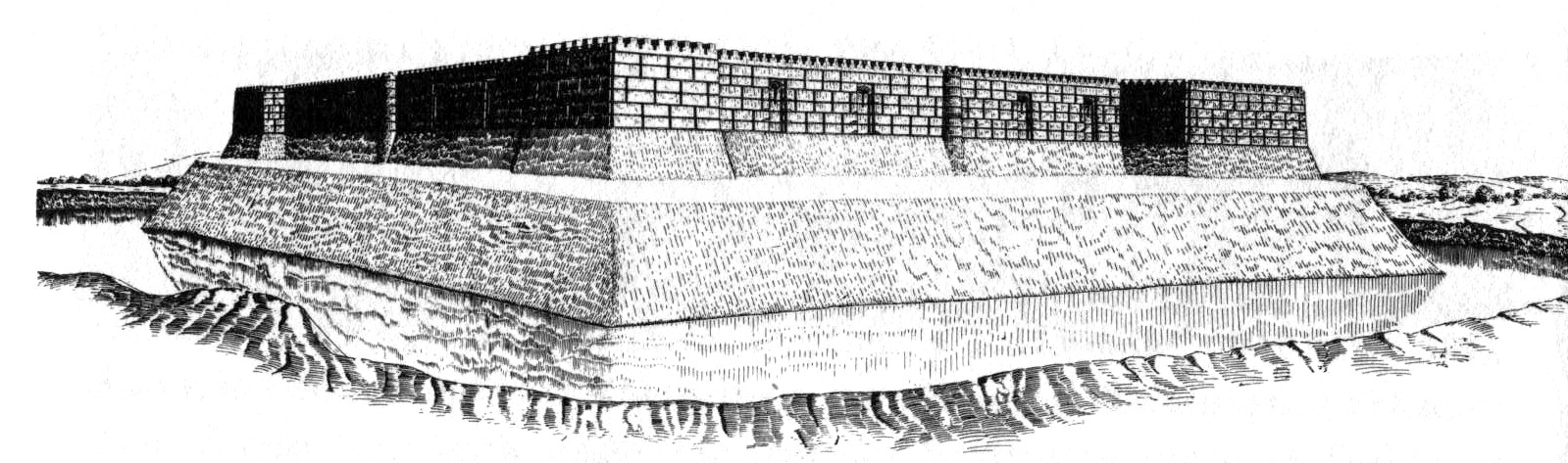
The settlement of Kafir Kala is divided into four distinct parts: citadel, city, suburb, and cemetery (east of the suburb, now built over). The city (šahrestān) together with the citadel form a square, each side 360 m long, oriented approximately to the cardinal points (Figure 1). It was surrounded on all sides by a large ditch, 50-60 m wide and 5 m deep, and by protective walls with towers. The citadel is located in the northeastern corner of the city. It is square (70 × 70 m) and rose 12 m above the surrounding plain. Even before excavation, one could see the niched walls and the projections of the corner towers. On the western and southern sides, the citadel is separated from the city by a ditch.
The city area was divided into equal northern and southern parts by the main road stretching across it east-west; a gate stood at either end. Side streets to the city quarters and buildings branched from the main road in either direction. The southern part of the city is more elevated than the northern, with distinctive mounds. The northern part, although also somewhat mounded, has a flatter relief. The city wall has the shape of a broad (5-10 m) rampart and is clearly visible. At intervals, the rampart suddenly widens and stands higher; these were the locations of towers, spaced 50 to 60 m apart.
The buildings of the suburb begin just outside the city moat. Their remains, in the shape of small mounds, can be traced to the north, west, and south of the city. An almost intact suburban farmstead is found 100 m from the southeastern corner of the city, in the courtyard of a modern house. It has the shape of a round hill (dia. 27 m, ht. 2 m).
Excavations at Kafir Kala were carried out in the city proper and on the citadel. Within the city, some residential complexes with adjacent streets were uncovered. Of special interest is site no. 1. Its central hall (17 × 7 m) stretches east-west, with the entrance in the eastern wall. The western frontal wall has a deep niche flanked by two decorative clay bands. The hall had a long history; initially, its walls were decorated by paintings with ornamental motifs. A silver Hephthalite (see HEPHTHALITES) coin of the Napki Malka type was found in a pile of bricks below remains of the upper floor. The building was erected in the 6th century CE (= KF-II period) Apparently, at that time some structures of the earlier (KF-I) period in the city were repaired and remained in use, side by side with the later (KF-II) structures. The excavations demonstrated that the KF-II period ended with the partial destruction of the city.
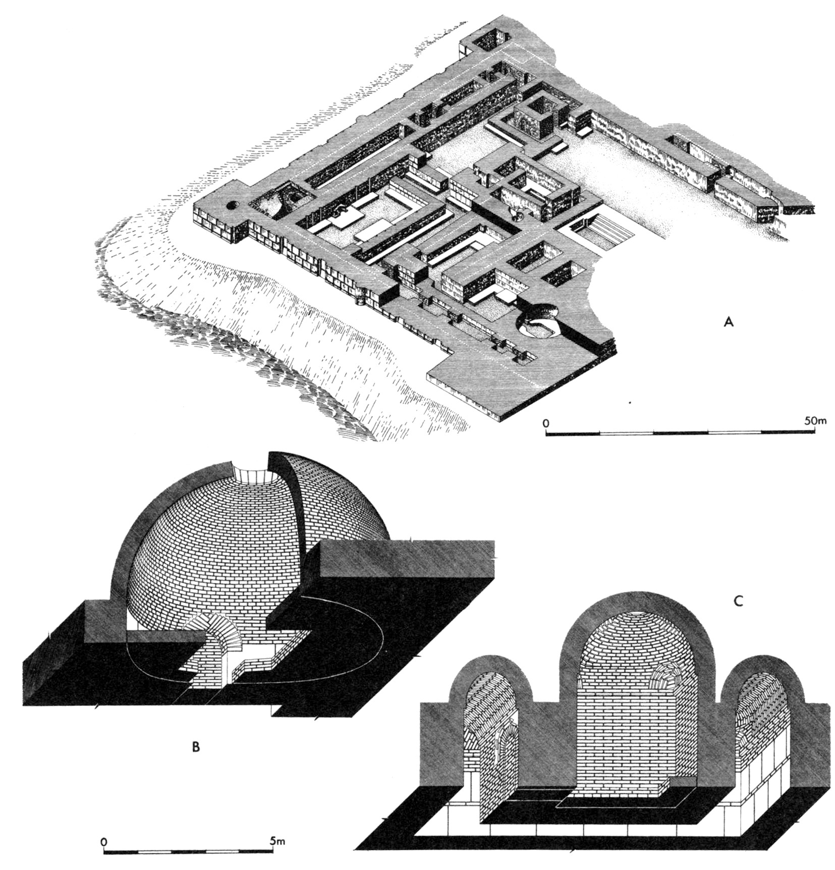
The elevated citadel (Figure 2) was uncovered almost entirely; it had been erected on a modest (ca. 2 m) loess platform and had three levels of construction. Detailed investigation of the middle (KF-II) and lower (KF-I) layers was prevented by the need to preserve the surface structures. It was determined, however, that the buildings of the earliest period (Figure 3) had been destroyed at the time when the structures of the middle level were built in their place. Artifacts were found to indicate that the earliest structures were built in the 3rd-4th centuries CE.
In the KF-II period, a complex of structures appeared on the citadel site, occupying it completely. One of the most significant structures was a rectangular hall on the northeast side (see below). A Buddhist monastery (vihāra) was built in the southeast corner. Among the other connected structures was a round room with domed ceiling (Figure 4, B). By the end of the KF-II period (5th to early 6th centuries), most structures of the complex had fallen into a state of neglect.
Period KF-III is characterized by a rebuilding of the complex and by the appearance of what can be justly considered a palace (although a palace complex probably had existed earlier as well). Part of the earlier complex was razed almost completely. Another part was rebuilt and decreased in size: the walls were strengthened by the attachment of buttressing walls (counterforts). Old passageways were blocked, and new passageways were cut. Side corridors that had been available in the previous period along the outer (northern and western) walls remained, but they were subdivided into separate sections, some of which were used as living quarters.
The main premise of the palace was the large (7 × 17 m) rectangular room on the northeast side of the complex. A sufa (dais) is built out along each wall. The sufa at one of the long sides widens and makes a raised rectangular platform, which is reached by stairs. One can suppose that this was the room where the throne (taḵt) of the ruler was mounted. Another raised platform was situated against the opposite wall; it accommodated a round hearth (or a fire altar?). Another large rectangular hall was found in the same vicinity. It too was located along the eastern city wall and comprised a chain of smaller halls.
The Kafir Kala palace of the KF-III period is of significant interest for its architectural composition. The space inside the citadel occupies practically all of the upper platform on which it stands, except for the southwestern yard. Here one can see, combined within a single building, the fortification works of a parade palace, along with living quarters and utility rooms.
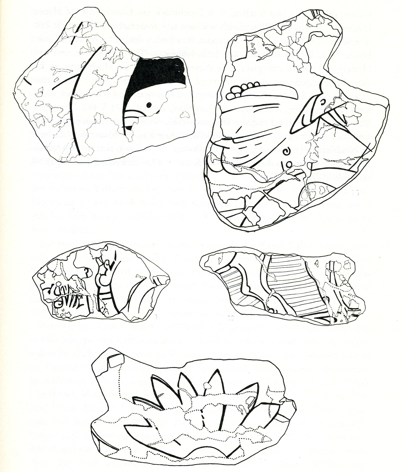
Special mention should be made of the Buddhist monastery (vihāra). It is characterized by a central cella (main sanctuary) encircled by a four-column corridor (Figure 4, C). This ayvān (q.v.) scheme is known in ancient Iranian architecture, from which it passed into Buddhist architecture. During the Arab conquest, the monastery was largely destroyed. There only remained fragments of polychrome wall painting with depictions of the Buddha, lotuses, and ornaments (Figure 5). This painting has close analogies in the paintings of Ajina Tepe (q.v.), Kalai Kafirnigan (Qalʿa-ye Kāfer-nehān), and Sinkiang (Litvinskiĭ and Solov’yov, pp. 109-13). Apparently, in the 6th to early 7th centuries (and possibly earlier), the ruler of the Vakhsh region practiced Buddhism. An accumulation of burnt birch-bark fragments was found during the excavations, with characters of the Brāhmī syllabary preserved on them. M. I. Vorob’yova-Desyatovskaya concluded (pp. 85-86) that these characters closely resemble the those on birch-bark manuscripts from other Buddhist centers of Central Asia.
Kafir Kala had a strong fortification system. The square perimeter of the city was surrounded by a ditch, and by two walls: an auxiliary outwork (Gk. proteichisma) and the main city wall—a strong curtain wall with projecting, half-round towers. The curtain walls were indented with high blind niches and also carried numerous false loopholes.
This city was the capital of the early medieval princedom of Vakhsh. No data is available with regard to its name. One can only add that an ostracon has been found containing a badly preserved inscription in Arabic. In one of its lines, V. A. Livshits read the words “speaks the emir,” and in another one he found the toponym Halāvard (Litvinskiĭ and Solov’yov, p. 121). The latter was the name for the largest city in the Vakhsh region in the Middle Ages. One can suggest that the city uncovered at Kafir Kala bore this name, and, after it had been destroyed by the Arabs, the name was transferred to the settlement which became a center later. It is clear, however, that this is only a hypothesis.
Bibliography :
A. M. Belenitskiĭ, “Otchet o rabote Vakhshskogo otryada v 1947 g.” (Report on the activities of the Vakhsh team in 1947), Materialy i issledovaniya po arkheologii SSSR 15, 1950, pp. 140-46.
B. A. Litvinskiĭ, Arkheologicheskoe izuchenie Tadzhikistana sovetskoĭ naukoĭ (kratkiĭ ocherk) (Archeological study of Tajikistan by the Soviet science: a brief survey), Stalinabad, 1954.
B. A. Litvinskiĭ, E. G. Gulyamova, and T. I. Zeĭmal’, “Raboty otryada po sboru materialov po sostavleniyu arkheologicheskoĭ karty” (Activities of the team on collecting materials for compiling the archeological map), Arkheologicheskie raboty v Tadzhikistane 4, 1956 (1959), pp. 133-34.
B. A. Litvinskiĭ and V. S. Solov’yov, Srednevekovaya kul’tura Tokharistana v svete raskopok v Vakhshkoĭ doline (Medieval culture of Tokharistan in the light of excavations in the Vakhsh River valley), Moscow, 1985a. B. A. Litvinskij and V. S. Solovjev, Kafyrkala: frühmittelalterische Stadt im Vachš-Tal, Süd-Tadžikistan, Munich, 1985b.
B. A. Litvinskij and T. I. Zejmal’, The Buddhist Monastery of Ajina-Tepa, Tajikistan: History and Art of Buddhism in Central Asia, Rome, 2004.
B. A. Litvinsky, “The Hephthalite Empire,” in History of Civilizations of Central Asia III, Delhi, 1999, pp. 135-62.
V. S. Solov’yov, Severnyĭ Tokharistan v rannem srednevekov’e (Northern Tokharistan in early Middle Ages), Yelets, Russia, 1997.
M. I. Vorob’yova-Desyatovskaya, “Pamyatniki pis’mom kkharoshtkhi i brakhmi v sovetskoĭ Sredneĭ Azii” (Written specimens in Kharoshthi and Brahmi scripts in Soviet Central Asia), Istoriya i kul’tura Tsentral’noĭ Azii (History and Culture of Central Asia), Moscow, 1983, pp. 22-96.
T. I. Zeĭmal’, “Raboty Vakhshkoĭ gruppy Khuttaevskogo otryada v 1957 g.” (Activities of the Vakhsh group of the Khuttaevsky team in 1957), Arkheologicheskie raboty v Tadzhikistane 5, 1957 (1959), pp. 83-95.
(Boris Litvinsky)
Originally Published: September 15, 2009
Last Updated: April 19, 2012
This article is available in print.
Vol. XV, Fasc. 3, p. 336 and Vol. XV, Fasc. 4, pp. 337-341