


THE PROVINCE
Ilām is one of the western provinces (ostāns) of Iran; and in the National Physical Plan (Ṭarḥ-e kā1bodi-e melli), which divides the country into 10 regions, it is part of the Zagros region (Figure 1). This region includes the provinces of Ilām, Kermānšāhān, Lorestān, and Hamadān and covers an area of 121,547.3 km² (7.45 percent of the entire country). In 1996, of Iran’s population of 66,623,000, 11.42 percent lived in the Zāgros region (Markaz-e moṭāleʿāt wa taḥqiqāt-e šahr-sāzi wa meʿmāri-e Irān, 1996, p. 33).
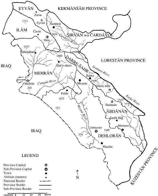
Ilām Province is situated between 31°58″ and 34°15″ N latitude, 45°24″ and 48°10″ E longitude. Its administrative center is the town of Ilām (see below). It is bounded by the provinces of Kermānšāhān in the north, Lorestān in the east, Ḵuzestān in the south, and by Iraq in the west and southwest with ca. 425 km of common boundary with the latter. Ilām occupies an area of ca. 2,015 km², ca. 1.4 percent of the total area of the country. This province includes 7 sub-provinces (šahrestāns: Ilām, Ābdānān, Darre-šahr, Dehlorān, Eyvān, Mehrān, and Širvān/Čar-dāvol), 17 towns, 18 districts (baḵšes), and 38 rural sub-districts (dehestāns).
In 1937, the sub-province of Ilām with 10 districts, 10 rural sub-districts, and 366 villages, and a population of 105,000, had been formed as part of the Fifth Province of Kurdistan and Kermānšāhān (Wezārat-e kešvar, p. 81). This administrative division remained in force until 1964, when the sub-province of Ilām was promoted into a governorate-general (farmāndāri-e koll), and it remained in that status until 1972. In the next year the administrative status of Ilām was changed again; it became a province (Wezārat-e kešvar, p. 26; for administrative divisions during the national censuses of 1966-96, see iii., below).
Topography. Ilām is divided into two distinct natural zones; the highlands of the northern and eastern parts of the province are occupied by the Zāgros range running in a northwestern-southeastern direction, whereas the southwestern part is covered by warm weather plains. The most important mountains of Ilām are: (1) Kabir-kuh, ca. 260 km long, parallel to the right coast of the Seymare (= Karḵe) river, with its highest point 2,790 m above sea level. This long mountain range divides Lorestān into a binary system of Poštkuh and Piškuh (Ilām Province and Lorestān Province). (2) Dinārkuh, in the northern sub-province of Dehlorān with the highest point at 1,955 m. Ābdānān sub-province is situated on its eastern slopes. (3) Šāh-naḵjir, in the southwestern area of Ilām sub-province and the northeastern part of Mehrān sub-province with the highest point at 1,898 m. (4) Siāh-kuh in Dehlorān sub-province, where it joins Dinār-kuh in the northeast with its highest point at 1,408 m; there are mineral springs on its southern slope. (5) Bānkuh mountain, in northern Ilām, 30 km long with the highest point at 3,304 m. (6) Šarazul, in the northwestern area of Ilām sub-province, with the highest point at 2,050 m. (7) Tavā-širḵāni mountain, in the northwestern part of Ilām sub-province, with the highest point at 1,505 m; there are several waterfalls (Jaʿfari, I, pp. 167, 268, 345, 356, 360, 422; II, pp. 286, 288; Afšār-Sistāni, pp. 43-48; Karimi, pp. 81-82; Sāzmān-e joḡrāfiāʾi, II, p. 356).
Rivers. These mountains are the source of many rivers, which flow in two directions. Firstly, eastward watercourses are tributaries of the Seymare (= Karḵe), including Čardāvol, a permanent river 22 km long, Sarābkalān, and Sarāb-zanjir. Secondly, westward watercourses that enter Iraqi territory include: (1) The permanent Konjān-čam river issuing from the mountains in the southern part of Ilām City, forming a limitrophe between Iran and Iraq. It enters Iraq under the name of Sirāo. (2) Gāvi river, which enters Iraq after a 45 km course in Persia. (3) The permanent Čangula river, which, after a 145 km course in Persian territory, empties into the Tigris. (4) Meyme, with a 145-km course in Iran, is also a tributary of the Tigris (Jaʿfari, II, pp. 177, 194, 404, 417-18, 458; Afšār-Sistāni, pp. 53-58; Edāra-ye joḡrāfiāʾi, p. 4).
Climate. The mountainous area of the province has a cold climate, with appropriate precipitation and relatively dense vegetation. The middle area of the provincecomprising the Dinār elevations has a temperate climate, and the western area has warm summers and temperate winters (Sāzmān-e havāšenāsi, p. 20; Afšār-Sistāni, pp. 49-51).
Caves. The important caves of the provinceare: (1) Ḡā-re Konā-tārika near the village of Pākol, 350 m deep. (2) Ḡār-e Ḵoffāš (“Bat’s cave”), 3 km from the town of Dehlorān. (2) Zinagān, also know as Ḡār-e behešt (“Paradise cave”), 5 km southwest of the town of Ṣāleḥābād. (3) Ḡār-e Tāyagol, 2 km from the village Vari (Zendadel, pp. 59-60).
Forests. The forest vegetation of the provinceis semi-dense in the elevations, mainly of balut (oak species: see BALUT, locally called māzu), mountain almond trees, mahlab (prunus mahaleb L.), wild pomegranate bushes, “the Persian turpentine tree,” wild almond trees, wild fig trees, zabān-gonješk (ash tree, fraxinus excelsior), wild cherries, senjed (“Bohemian olive,” Elaeagnus angustifolia), arḡavān (Cercis siliquastum), wild pear, sumac, etc., as well as medicinal, tinctorial, and gummiferous plants such as astragalus (garan)species, gol-e gāv-zabān (flowers of Anchusa officinalis or tinctoria). The most important vegetable gum of the province is saqqez,obtained from bene, avariety of wild pistachio (Pistachia acuminata). About 350tons of saqqez are produced annually (Afšār-Sistāni, pp. 65-72).
Pastures. The climatic variety of the provincehas resulted in rich, all-season pastureland, which constitutes an important area for animal husbandry in the country. In 1988, there were 1,350,641 sheep, 828,493 goats, and 63,173 cows in the province (Sāzmān-e barnāma, p. 225). Furthermore, the multitude of watercourses has enriched the fauna; in addition to river fishes, one finds varieties of lizards, venomous snakes, brown bears, leopards, wild boar, stags, foxes, ibex, wolves, hares, bats, and a great variety of birds, (Afšār-Sistāni, pp. 73-76).
Agricultural produce. The most important agricultural products as of 1998 were cereals (330,000 tons), watermelons and other kinds of melon (91,000 tons), tomatoes (753 tons), potatoes (799 tons), onions (9,800 tons), cucumbers (65,000 tons), and dates, etc., which are mainly exported to other provinces(Sāzmān-e barnāma, pp. 183-86). Export of raw wool, ghee, and livestock are also major sources of revenue for the inhabitants (Edāra-ye joḡrāfiāʾi-e arteš,56, p. 49; 68, pp. 40-41).
Handicrafts. Due to the abundance of raw materials, specific handicrafts are produced, particularly by tribal people: carpets (large and small), jājims(a kind of coarse, thin woolen cloth), ḵorjins(a kind of woven woolen saddle bags), siāh-čādors(“black tent”; used by local nomads), felt, etc. The province’s minerals of importance are naphtha, various stones, chalk, and rock salt (Afšār-Sistāni, pp. 483-94).
Principal tribes. The main tribes of Ilām are: (1) Il-e Malekšāhi. (2) Il-e Šuhān, with eight clans(ṭāyefas). (3) Il-e Kord, with six clans. (4) Il-e Ḵazal with four clans. (5) Il-e Arkavāzi with ten clans. (6) Il-e Kalhor. (7) Il-e Eyvān with two clans (Markaz-e āmār-e Irān, pp. 31 ff.; Afšār-Sistāni, pp. 371-401).
Ilām in the Iran-Iraq War. During the first decade of the dominance of the Baath (Baʿṯ) Party in Iraq, in the seven-year period 1968-75, over 100 cases of armed clashes occurred between the forces of the two countries in the areas of Mehrān, Fokeh, Musiān, ʿAyn-e Ḵoš, and Meymak. The agreement of 6 March 1975 between Iran and Iraq in Algeria resulted in a period of détente that lasted until 1979. The demarcation of definitive and territorial borderlines (an old political issue) between the two countries progressed slowly. The crisis and hostilities resumed in 1979, that is, after the establishment of the new Islamic regime in Iran. Iraqi troops massed opposite the northern and middle areas of Ilām Province. On 16 September 1980, Iraq unilaterally nullified the Algeria agreement, and on 21 September 1980 Iraqi forces launched an all-out attack against Ilām. They occupied the areas of Mehrān, Čangula, Čilān, Dehlorān, Musiān, and Fokeh, and cut the connection along the Ilām-Mehrān-Dehlorān route. Thus Iran’s border was occupied for several kilometers. After seven years of open warfare, parts of Ilām were still under Iraqi occupation. Finally, after the acceptance by both countries of the Security Council’s resolution no. 598 of 1987, despite two years of “cold war,” Iraq and Iran reconfirmed the 1975 Algeria agreement; and thereafter the areas occupied by Iraq were fully recovered (Markaz-e moṭāleʿāt wa taḥqiqāt-e jang, pp. 13, 14, 24-26, 30).
THE CITY
The city of Ilām is situated at at 33°38″ N latitude, 46°26″ E longitude at 1,440 m above sea level. Although situated in the plain of Ilām, the city is encircled by individual mountains. The most important river traversing the city is the Godār-e Ḵoš, that later enters Iraqi territory (Edāra-ye joḡrāfiāʾi-e arteš, no. 56, p. 6). According to the Ilām meteorology station, the highest temperature of the town is 37°, the lowest -10°, and the annual precipitation is 667.6 mm (Sāzmān-e havā-šenāsi, 1979, p. 64).
The area in which the city was developed used to be a village (Deh-e bālā), the summer campsite of Ḥosaynqoli Khan Abu Qaddāra, the powerful wāli of Poštkuh (1857-1900). He constructed a garrison, mansions, and a fortress in the village for his harem and headquarters called Qalʿa-ye wāli. After his name, Deh-e bālā was known as Ḥosaynābād-e Wāli and served as the administrative center of Poštkuh. Following the suppression of tribal forces and consolidation of central authority in the region during the late 1920s and early 1930s, Ḥosaynābād became the administrative center of the sub-province of Lorestān-e Poštkuh; in 1936, its name was changed to Ilām (Afšār- Sistāni, p. 29; Bahār, II, p. 269). Folllowing the sedentarization of local tribes by Reza Shah, and after security was established in the area in the 1930s, all state offices were centralized there; and the town underwent a period of urban development (Ḥosayn-ʿAli Razmārā, V, p. 22). The city saw rapid population growth during the latter half of the 20th century, and its population increased from 8,346 in 1956 to 126,346 in 1996 with an annual growth rate of over 7 percent (see iii., below).
Bibliography
Iraj Afšār-Sistāni, Ilām wa tamaddon-e dirina-ye ān (Ilām and its ancient civilization), Tehran, 1993.
Moḥammad-Taqi Bahār, “Ilām-ʿIlām,” in Bahār wa adab-e fārsi, ed. Moḥammad Golbon, Tehran, 1976, pp. 268-69.
Edāra-ye joḡrāfiāʾi-e arteš, Farhang-e joḡrā fiāʾi-e ābādihā-ye kešvar (Gazetteer of the villages of Iran): Ilām, no. 56, Tehran, 1993; Bostān, no. 68, Tehran, 1986; Dehlorān, no. 78, Tehran, 1986.
ʿAbbās Jaʿfari, Gitā-šenāsi-e Irān: kuhhā wa kuh-nāma-ye Irān (Mountains of Iran), Tehran, 1989.
Bahman Karimi, Joḡrāfiā-ye mofaṣṣal-e tāriḵi-e ḡarb-e Irān (Comprehensive historical geography of western Iran), Tehran, 1937.
Markaz-e āmār-e Irān, Šaršomāri-e ejtemāʿi-eqteṣādi-e ʿašāyer-e kučanda (Socio-economic census of migratory tribes), Tehran, 1998.
Markaz-e moṭāleʿāt wa taḥqiqāt-e jang, Ilām dar jang (Ilām in the war), Tehran, 2001.
Markaz-e moṭāleʿāt wa taḥqiqāt-e šahr-sāzi wa meʿmāri-e Irān, Ṭarḥ-e kālbodi-e manṭaqa-ye Zāgros (Physical plan of Zagros region), 3 vols., Tehran, 1999.
Ḥāji-ʿAli Razmārā, Joḡrāfiā-ye neẓāmi-e Irān, Poštkuh (Military geography of Iran, Poštkuh), Tehran, 1941.
Ḥosayn-ʿAli Razmārā, Farhang-e joḡrāfiāʾi-e Irān, ostān-e panjom, Kordestānwa Kermānšāh (Geographical dictionary of Iran, fifth province, Kordestān and Kermānšāh) V, Tehran, 1952.
Sāzmān-e barnāma wa budja, Āmār-nāma-ye ostān-e Ilām 1377 (Statistical profile of Ilam, 1998), Tehran, 1999.
Sāzmān-e havāšenāsi-e kešvar, Sāl-nāma-ye havāšenāsi 1375-76 (National meteorological yearbook, 1996), Tehran, 1998.
Wezārat-e kešvar, Qānun-e taqsimāt-e kešvar wa waẓāyef-e farmāndārān wa baḵ-šdārān, moṣwwab-e 1316 (The Law of national administrative divisions …, 1937), Tehran, 1937.
Ḥasan Zendadel, Ostān-e Ilām (Ilām Province), Tehran, 2000.