

DARVĀZA (gateway), generally an entrance opening wide enough to permit passage of vehicles, in contrast to doorways, which are smaller openings to permit passage through a wall or fence (Wasmuths Lexikon, pp. 544, 565).
Gateways are found in the walls of every kind of enclosure: castles, fortresses, small or medium-sized settlements, and cities. They are known to have existed from the earliest days of castle and city construction and to have evolved as part of the general development of fortification architecture. From prehistoric times the gateways of castles and fortresses were usually flanked by round or rectangular towers. This combination of entrance with flanking towers was also adopted for rebāṭs (fortified monasteries) and caravansaries (Kleiss and Kiani, 1983, p. 85: Dayhr). The symbolism of the two-towered plan in palace and other public buildings can be traced to this origin (Diez, p. 193). This type of gate structure could also be adapted to the typical ayvān entrance, as in the facade of the Šīr-dār madrasa in Samarqand (1019/1610; Diez, p. 81). Gate structures thus also served nondefensive functions, both in fortified cities and in the open countryside.
Only city gates will be treated here. They are sufficient to reveal a continuous development in architectural history, though discussion here will be limited to the Iranian cultural circle. At the beginning of this development, in the 3rd millennium B.C.E., stands the fortified castle settlement of Bolūrābād near Qara Żīāʾ-al-Dīn in western Azerbaijan, a prehistoric site in which a simple, unelaborated opening in the wall marks the gateway (Figure 4a; Kleiss, 1975). At another walled settlement from the 3rd millennium B.C.E., Yaḵvalī, east of Mākū, there is evidence that already the line of the fortress walls was laid out in order best to exploit the features of the terrain for defensive purposes. There too, however, the gateway was a simple opening in the walls, without special reinforcement (Figure 4b; Kleiss, 1979).
A more effective defensive layout is represented by the gateway to the strongly fortified settlement of Rāvāz southwest of Mākū, which stands at the junction of the trade routes from Anatolia to Central Asia and from Mesopotamia to the Caucasus and belongs to the 2nd or 3rd millennium B.C.E. (see CASTLES). There an early form of the gateway with flanking projections can be identified (Figure 4c); along with the entire fortifaction wall, which is buttressed by towers or bastions, its placement was dictated by the terrain (Kleiss, 1979, pp. 31-33).
Like Rāvāz, the Urartian remains at Dūčgagī represent a more advanced stage in the evolution of settlements and can be considered those of a full-fledged town (Figure 4d). Located southeast of Mākū on an unfortified clifftop with sheer drops on three sides, it was separated on the fourth side from an outer settlement and protected against assault by a fortified wall in which the simple gateway opening was flanked by a single tower (Kleiss, 1978, pp. 36 ff.). Similarly, the easternmost of the two gates at Qalʿa-ye Esmāʿīl Āqā (Figure 4e), a large fortified Urartian settlement of the 8th-7th centuries B.C.E., was entered through a passage, rather like a dromos, at a point where the topography of the site dictated a step back in the fortification wall (Kleiss, 1977, pp. 64 ff.).
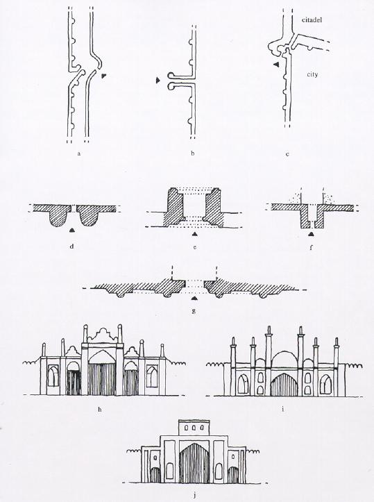
More typical of Urartian fortifications was the 8th-century B.C.E. city wall of Ḥasanlū, with a gateway (Figure 4f) flanked by two massive rectangular towers. In addition, the gate itself was articulated by two flanking projections on the exterior (Dyson and Muscarella, pp. 3-4). At Veraḵram on the Aras (Araxes) an 8th-century Urartian city wall was elaborated in a later rebuilding by the addition of a small gatehouse (Figure 4g), which was further strengthened by a strongly projecting tower (1974, pp. 82 ff.). On the southern bank of the Aras, east of Jolfā, in the walled 6th-century B.C.E. settlement of Qalʿa-ye Gavūr there is only a simple gate opening (Figure 4h) in one corner of the wall (Kleiss, 1976, pp. 107 ff.). At a 6th- or 5th-century B.C.E. site also known as Qalʿa-ye Gavūr, southwest of Ḵᵛoy, there is a bent-axis gateway (Figure 4i; Kleiss, 1978, pp. 34 ff.). The outer gate of the fortified settlement of Qalʿat southeast of Urmia, also of the 6th century B.C.E., was flanked by two strong rectangular towers (Figure 4k; Kleiss, 1978, pp. 41 ff.). This type of gateway can also be seen on an Assyrian relief representing a “Median” city gate viewed from the front (see, e.g., Kleiss, 1982a). To judge from this relief, the arched gates of the 6th-5th centuries were flanked by towers that rose above the crenellated tops of the adjoining walls and supported enclosed battle platforms encircled by crenellations (Figure 4j). This representation is, however, primarily symbolic, and it is not possible to draw from it conclusions about the proportions of actually existing architecture.
From the 5th and 4th centuries B.C.E. one Achaemenid city gate, the eastern gate of the Ville Royale in Susa (Figure 4l), is known. Its form, a cubical structure projecting from the line of the walls, with a central entrance passage flanked by pairs of deep recesses, can be traced to Hittite models, as at Carchemish (Naumann, p. 301), and to city gates from Palestine and adjacent lands of the 12th-10th centuries B.C.E. (Carter, p. 41 fig. 1; Herzog). The characteristic palace gates of Persepolis are not relevant here.
The ruined gate of Eṣṭaḵr near Persepolis, which, judging from its structure and the technique of working the stone, belongs in the late Achaemenid or Seleucid/Hellenistic period, exhibits an unusual plan (Figure 4m). It stands outside the city of Eṣṭaḵr, which lies to the north of it, between the city and an extensive settlement area that was obviously once surrounded by a fortified wall; the presence of this settlement has been established from the typical relief-carved “Eṣṭaḵr ceramics” found in the area. It is obvious from topographical observations (Kleiss, 1992, pp. 235-36 fig. 2) and investigations (Calmeyer-Seidl, personal communication) that the ruins, which certainly served the function of a gateway on the track of the ancient road from Persepolis (Shiraz) to Pasargadae (Isfahan and Yazd), also served to link the two settlement areas across the caravan route (survey by Kleiss, 1990). Not only the road passed through the gate of Eṣṭaḵr but also a water canal (Figure 4m). Two half-columns and a central column divided the passage into two aisles. The space within the gate structure can thus be viewed as a kind of gatehouse.
Datable to the 4th-1st century B.C.E., in the Seleucid and Parthian periods, is Koi Krylgan Kala, the ruins of the former burial palace of the Chorasmian dynasty, later transformed into a settlement. The plan of the gateway was dominated by two flanking semicircular buttresses (Figure 4n); this arrangement, whether of semicircular or of rectangular towers, was predominant in later gate plans, as well as in city walls (Brentjes, p. 51).
In the Sasanian and early Islamic periods rectangular towers most commonly flanked the gateways in city walls, as is clear from the unexcavated northern gate of the round city of Dārābgerd (Figure 4o; see DĀRĀB ii), here shown with flanking projections, and from the gate of Qaṣr-e Abū Naṣr (Figure 4p), south of Shiraz, with fully developed towers (Whitcomb).
In the later Islamic period in Persia and the areas of its cultural influence heavy semicircular towers flanking gateways in city walls predominated; examples are preserved at Yazd and at Bam (Figure 5d). Unfortunately, a great number of Persian city gates have been completely destroyed in the last 100 years, owing to the increase in modern automobile traffic and breaches in the walls made for thoroughfares. Among the few preserved examples it is nevertheless possible to find solutions other than the two-towered gate facade.
At Marūčak in Afghanistan, for example, a gateway between two circular towers is related to the European type of narrow passage preceding the gate opening (Zwingertor; Figure 5b). It is not clear whether there were both exterior and interor gates at Marūčak, but it seems probable. This construction can be dated to the 10th-13th centuries (Ball, I, p. 180; II, pl. 42.1). Another gateway between two exterior round towers has been incorporated into the modern city wall of Herat; the entrance passage is oblique to the fortification wall, which was buttressed by rhythmically placed towers, and there was a simple outer wall without towers and with simple gate openings (Figure 5a; Brandenburg, p. 20 map v).
In the medieval city wall of Dāmḡān a single gateway has been preserved at the point where the city wall meets that of the citadel (Figure 5c); its form is that of a projecting angular buttress of the citadel wall, and the passage makes several turns as it leads into both the citadel and the city area. It is impossible to see into the interior from outside, and thus an attacker could not shoot through the passage (Kleiss, 1982b, p. 376).
In the 18th and early 19th centuries, beside gateways flanked by semicircular towers, as at Bam (Figure 5d), there were also other gateway plans, for example, the passage through a towerlike gatehouse, as at Īzadḵᵛāst near Ābāda (Figures 5f, 6), or an architectonically constructed gate flush with the line of the city wall at Ḵᵛoy in western Azerbaijan, which was reinforced by buttresses betraying European influence (Figure 5e). The remains of the gate at Ḵᵛoy, which is ornamented with stone relief carving and directly connected on the interior to the vaulted street of the bāzār, are still well preserved (1977a).
A few examples of 19th-century gateways can still be found in Persia, some of only moderate size (as at Tehran), some well preserved (as at Semnān and Qazvīn), and some reconstructed (as at Shiraz). The southern gateway in the earlier wall of the old city of Tehran, the Moḥammadīya gate (leading to Moḥammadīya and Ray), was built by Moḥammad Shah Qājār (1250-64/1834-48; Figure 5g). Like the gateway at Ḵᵛoy, it is flush with the walls; it is decorated with tiles and flanked by two slightly projecting towers (Kleiss, 1977b). The Qajar gateways at Tehran, Qazvīn, Semnān, and Shiraz had no special defensive function, except that they could be closed at night and for the collection of customs duties. They are nevertheless city portals and are thus lavishly decorated, mainly with tiles. At the Tehran gate in Qazvīn (Figure 5h) and at the Qorʾān gate in Shiraz (Figure 5j) the main vehicle entrances were wide and tall; they were flanked by two pedestrian passageways. The Tehran gate at Semnān and the Moḥammadīya gate in Tehran had only single entrances for vehicles, riders, and pedestrians (Figure 5g and Figure 5i). The towers that nowadays stand separate from the line of the walls were of course integral parts of the original city walls.
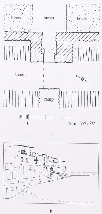
A still well-preserved example of a city gate from the 18th or 19th century is that at Īzadḵᵛāst (Figure 6). It is the only gate to the city, which is entirely surrounded by steep precipices. On the west side a trench has been dug; it was formerly crossed by means of a wooden bridge. The entrance is through a gatehouse, which stands lower than the houses on both sides of the main street; it juts out from the line of the city wall, which serves at the same time as the foundation for houses built on top of it. The wooden bridge, which is no longer extant, was not a drawbridge. Instead, the outer entrance to the gatehouse was closed by double doors with stone wings, and the closed door could be barricaded on the interior with wooden beams in emergencies. The gate thus provided the inhabitants of the town with sufficient protection from attack.
Bibliography:
C. Amory, Jr., Persian Days, London, 1928.
W. Ball, Archaeological Gazetteer of Afghanistan, 2 vols., Paris, 1982.
D. Brandenberg, Herat, Graz, 1977.
B. Brentjes, Mittelasien, Vienna, 1977.
E. Carter, “Excavations in Ville Royale I at Susa. The Third Millennium B.C. Occupation,” CDAFI 11, 1980, pp. 7-134.
E. Diez, Die Kunst der islamischen Völker, Berlin, 1917; repr. Potsdam, n.d.
R. H. Dyson and O. W. Muscarella, “Constructing the Chronology and Historical Implications of Hasanlu IV,” Iran 27, 1989, pp. 1-27.
Z. Herzog, Das Stadttor in Israel und in den Nachbarländern, Mainz, 1986.
W. Kleiss, “Planaufnahmen urartäischer Burgen und Neufunde urartäischer Anlagen in Iranisch-Azerbaidjan im Jahre 1973,” AMI, N.F. 7, 1974, pp. 79-106.
Idem, “Bolurabad I. Die Architektur,” AMI, N.F. 8, 1975, pp. 15-20.
Idem, “Zwei Plätze des 6. Jahrhunderts v. Chr. in Iranisch Azerbaidjan A. Die Bauten,” AMI, N.F. 9, 1976, pp. 107-16.
Idem, “Ergänzung zum Stadttor von Khoy,” AMI, N.F. 10, 1977a, pp.323-24.
Idem, “Das Muḥammadiyeh-Tor in Alt-Teheran,” AMI, N.F. 10, 1977b, pp. 341-44.
Idem, “Urartäische Plätze in Iran A. Architektur,” AMI, N.F. 10, 1977c, pp. 53-83.
Idem, “Urartäische Plätze und Anlagen des 2.-1.
Jahrtausends v. Chr. in Iran A. Architektur,” AMI, N.F. 11, 1978, pp. 27-59.
Idem, “Ravaz und Yakhvali, Zwei befestigte Plätze des 3. Jahrtausends A. Architektur,” AMI, N.F. 12, 1979, pp. 27-34.
Idem, “Darstellungen urartäischer Architektur,” AMI, N.F. 15, 1982a, pp. 53-77.
Idem, “Die islamische Festung am Tepe Hissar bei Damghan,” AMI, N.F. 15, 1982b, pp. 376-88.
Idem, “Brücken aus Zentral- und Südiran,” AMI, N.F. 25, 1992.
Idem and M. Y. Kiani, Iranian Caravansarais I, Tehran, 1362 Š./1983.
R. Naumann, Architektur Kleinasiens, Tübingen, 1971.
Wasmuths Lexikon der Baukunst IV, Berlin, 1932.
D. S. Whitcomb, Before the Roses and the Nightingales. Excavations at Qasr-i Abu Nasr, Old Shiraz, New York, 1985.
(Wolfram Kleiss)
Originally Published: December 15, 1994
Last Updated: November 17, 2011
This article is available in print.
Vol. VII, Fasc. 1, p. 66-71