


BISOTUN
ii. Archaeology
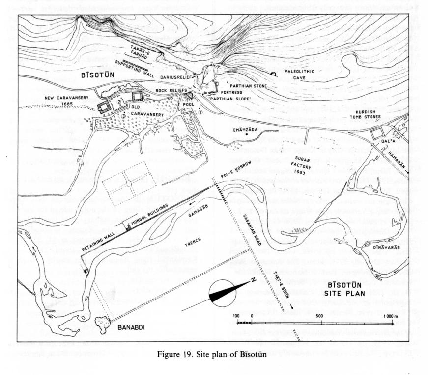
Although the relief and inscription of Darius on the cliff have made Bīsotūn famous, there are also various other remains in the neighborhood, including some that were discovered or identified only in 1962 and 1963. All these remains will be described here in chronological order (see Figure 19, plan of Bīsotūn).
Prehistoric remains. Some Paleolithic cave finds are the earliest evidence of human presence at the spring-fed pool of Bīsotūn (Coon, 1951, pp. 1ff.; 1957, p. 86, pls. 5-8; Golzārī, I, pp. 326ff., fig. 242). Next come traces of a 2nd-millennium settlement on the “Parthian slope” (Kleiss, pp. 133ff., esp. p. 159, pls. 75.3, 76.2; Luschey, 1974, p. 112). In addition, fragments of prehistoric pottery washed down from the ravine have been found in the debris below the relief of Darius (Luschey, 1974, p. 118, fig. 12).
The Median fortress. This name has been given to the remains of a fortress on the mountain slope because a bronze triangular fibula of the 8th/7th century b.c. was found in its wall (Kleiss, p. 174, fig. 221, pl. 75; Luschey, 1974, p. 118, fig. 11). The fortress was first investigated by F. Hinzen, then fully explored by W. Kleiss (pp. 133ff., plan fig. 20). In its construction, with rectangular buttresses, it resembles the fortress at Tepe Nūš-e Jan, which is not very far away (Stronach, 1978, 1981; idem, 1986, p. 289, fig. 7). Probably it was the old fortress named Sikayauvatiš where Darius and his companions slew Gaumāta, as reported in his inscription (Kent, Old Persian, DB 1.58, pp. 118, 120, 209; Luschey, 1968, pp. 66f.; 1974, p. 118); this identification would explain Darius’ decision to place his relief about 100 m from the gateway. Beside this gateway a relief depicting Heracles was erected in the Hellenistic period. His lion-skin cloak appears to be a separate figure and was taken by D. Stronach to be a Median gate monument (see Kleiss, pp. 145f., fig. 11, pl. 66.1-4; Luschey, 1974, p. 119), but the figure is not modeled in the round as a gate lion would be, is not on the line of the gateway, and has no counterpart on the opposite side. The terrace below the relief of Darius, which was covered with debris from the relief, may well be Median or early Achaemenid—perhaps for the worship of an earlier image that has not been preserved (Luschey, 1968, p. 66, figs. 1-2; 1974, p. 118, figs. 6-8).
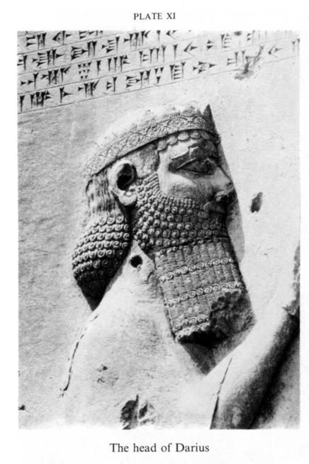
The relief and inscription of Darius (Plate X and Plate XI). In 1963-64 the present writer had the opportunity to study this relief from a scaffolding and to take photographs that have served as the basis for all subsequent research (Luschey, 1968, pls. 29-42). In the text accompanying the publication of these photographs an attempt was made to draw up a detailed inventory of the motifs and stylistic features of the relief. Attention was also drawn to a previously unnoticed inconsistency in the distribution of the accompanying inscriptions, which led me to recognition that the Elamite text is the oldest and that the Babylonian and Old Persian versions were added later. The evidence is thus clear that Old Persian cuneiform script was introduced only after the relief was completed, that is, about 520 b.c. (see iii, below; Luschey, 1965, pp. 19-41; 1968, pp. 91f.; and Hinz, pp. 95ff.; see also Trümpelmann, p. 281).
The relief of Darius is the first great expression of Achaemenid art in the idiom of his reign. In the modeling of figures it far surpasses anything from the time of Cyrus. The difficult task of portraying the defeat of the “false kings” in stone was accomplished by the same means as in the Anabanini relief from the 3rd millennium b.c.: by using scale to indicate importance. Darius and his allies Gobryas and Artaphernes are clearly distinguished in this way from the small-sized rebels. Over the entire scene hovers the beneficent god Ahura Mazdā, who is repeatedly invoked in the inscription. The extreme precision of detail in the carving can be appreciated only from close up, but it is now known that not only were replicas of the inscription put up in several localities but also that a copy of the relief itself was erected at Babylon (Seidl, pp. 125ff., pls. 34-37), presumably in a less lofty position.
The principal studies on the relief and inscription are given at the end of iii below; see also Golzārī, pp. 339-64, figs. 244-71. For descriptions and interpretations by early travelers, see Luschey, 1969, p. 63 n. 2; 1974, pp. 139ff. Assessments of the reliefs from an artistic point of view can be found in Sarre and Herzfeld, pp. 189ff.; Herzfeld, 1920, pp. 16ff.; Schmidt, 1953, pp, 38ff.; Luschey, 1968, pp. 63-94, pls. 24-42; 1974, pp. 118f.; Farkas, 1974, pp. 30ff., pls. 13f., 1985, pp. 82ff., pls. 34f.
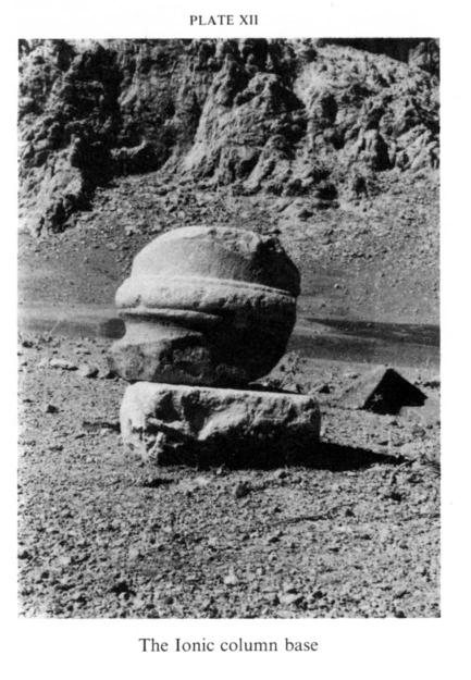
The Ionic column base from the Bīsotūn cemetery (Plate XII). This architectural fragment is a piece of light-colored dressed sandstone. It was found in the Bīsotūn cemetery by the writer in 1962 and was removed, with the village headman’s consent, to the excavation depot; it is now kept at Ṭāq-e Bostān. The piece is an Ionic column base in the Attic style, with a projecting lower torus, a curved concavity, and an upper torus, as in the classical example on the north porch of the Erechthcion at Athens. The diameter of the column base is 52 cm, that of the column shaft 42 cm. The preserved height is 33 cm. In 1974 the writer noted (Luschey, 1974, p. 121) Herzfeld’s comment that “the greatest visitor [to Bīsotūn] did not record his name” (p. 31). But, as Alexander did cause a lion monument to be erected at Ecbatana in honor of Hephaestus (Luschey, 1968, pp. 115-22), it seems plausible to speculate that, during his preceding march to Bīsotūn after learning that its “mountain of the gods” was sacred to Heracles, he erected a naiskos for Heracles Callinicus there. The closest parallel for the column base is at Aï-Khanum (Āy-ḵānom; Schlumberger, 1969, p. 28 Bild 2), the Greek town on the Oxus now known to have been founded by Alexander, and it may therefore be cautiously suggested that the Ionic column base is the only known remnant of a building erected at Bīsotūn by Alexander. Such a building could have been a naiskos of about the same size as the temple of Nike on the Acropolis at Athens, where the column bases have exactly the same diameter, 52 cm.
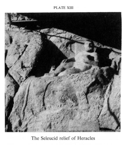
The Seleucid figure of Heracles from 148 B.C. (Plate XIII). This rock carving of Heracles recumbent is in such high relief that it almost seems to have been sculpted in the round. It was found by ʿA. Ḥākemī during work to lower the level of the main road (1338 Š./1959-60, pp. 3ff.; Luschey, 1968, p. 30, pl. 16.2, 1974, pp. 122f., pls. 15-16; Golzārī, pp. 367-69, figs. 272-76). It is a clumsy piece of work, not up to the standard of the period, but important because of its datable Greek inscription. Perhaps inspired by a carving from the time of Alexander, it is an early example of the tradition of portraying Heracles reclining. Opinions differ on the question whether the figure of a lion below that of Heracles is a somewhat unusual depiction of the lion skin on which he is supposed to be reclining or, as D. Stronach supposed, an independent carving from the Median period (see above).
Parthian remains. These comprise reliefs of Mithridates II (123-87 B.C.) and Gotarzes II (ca. 50 b.c.) and the Parthian stone (see Herzfeld, 1920, pp. 35ff., pls. 21-23, 52a). These rock carvings were among the earliest discoveries at Bīsotūn. The relief of Mithridates depicts four satraps in a line before the king, with all the figures in profile, and thus is still strongly within the Achaemenid tradition. The relief of Gotarzes, which shows horsemen in combat and Nike hovering above, is more in a Roman style. Both these somewhat provincial works have suffered damage from weathering, and part of the Mithridates relief has been obliterated by the insertion in 1094/1684-85 of a waqf inscription by Shaikh ʿAlī Khan Zangana, who also built the New Caravansary (Gropp and Nadjmabadi, pp. 211ff.). This Zangana was an ancestor of the engineer Zangana of Kermānšāh, who established the sugar factory at Bīsotūn only 800 m from the relief of Darius. The Parthian stone, first discovered by O. Mann (1903, p. 328, fig. 2), bears a very crude carving of a sacrificial victim on an altar and another human figure beside it. The name in the inscription has been read by Gropp, (Gropp and Nadjmabadi, pp. 200f., fig. 14, pl. 101) as Vologases. Five Parthian kings named Vologases reigned between a.d. 51 and 228 (See balāš).
For further discussion and illustrations of the Parthian reliefs, see Ghirshman, 1954, p. 279, pl. 35b, 1962, p. 53, pl. 66; Vanden Berghe, p. 107, pls. 133c-d; Kleiss, p. 133, pl. 72.1; Luschey, 1974, pp. 124f. figs. 17, 18; Schlumberger, pp. 1041, 1078, pl. 64; Huff, 1984, p. 246, pl. 25; Golzārī, pp. 371-76, figs. 277-83; [Kawami].
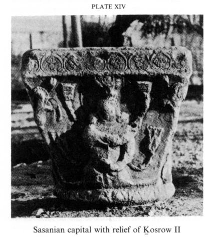
Sasanian remains. The three large sculptured capitals (Plate XIV, Plate XV). These capitals were the first Sasanian remains at Bīsotūn to attract attention, having been sketched by G. A. Olivier in 1796 (Luschey, 1974, p. 128, figs. 19-24, p. 141, fig. 41a). After the relief of Darius, they are the most significant monuments at Bīsotūn, constituting important documents for the history of Sasanian art (their find spots are marked 1-3 on the plan; see also Golzārī, pp. 388-94, figs. 300-06). The question of where and when they were originally erected has been highly controversial. Herzfeld (1920, pp. 104ff., pls. 55-59) considered them to be from Ṭāq-e Bostān and datable to the reign of Ḵosrow II (590-628), though he mentioned that two of them had been found at Bīsotūn (p. 111, fig. 28), whereas Erdmann (1943, pp. 1ff.) argued for Bīsotūn and the reign of Pērōz (459-83). In the opinion of the present writer, they belong to Ḵosrow’s reign (Luschey, 1968, pp. 129ff., pls. 51-54).
On each capital the king is portrayed on one side and the goddess Anāhīd on the opposite side; the remaining two sides are carved with floral ornament, including finely detailed lotus plants. Together with a fourth capital, now missing, they must have formed an architectural unit in which the goddess on one capital presented the garland of sovereignty to the king on the next capital, each capital and its column being linked to the next by an arch. In an attempt to find the original position of this unit, the writer dug some trial trenches in an area beside the Bīsotūn pool, but no trace of any former structure was found. It was impossible to explore the whole area, however, as part of it is covered with massive buildings. Another possibility is that the site of the capitals may have been on the bank of the Gamašāb some 100 m north of the Mongol building, at the point where the retaining wall intersects with one axis of a 19th-century garden (which probably follows an older alignment). Various Sasanian architectural remains, including one section of a profile, a piece of column, and some fragments of stone blocks, have been discovered closer to the Mongol building. At any rate, a site near water would explain the portrayal of Anāhīd on the capitals. She is similarly associated with Ḵosrow II on the reverse of one of that king’s silver coins. The capitals are products of the last flowering of Sasanian art, in the years around a.d. 600, in Ḵosrow II’s reign, and cannot be dated to the 5th century, which would shorten the history of Sasanian art by 150 years.
The Gamašāb retaining wall. These remains, which previous investigators had missed, were pointed out by local people. They are 5 m thick and faced with two or three courses of large blocks, mostly 70 cm high; the infill is of small stories set in mortar. On the land side the wall reaches a height of about 5 m (Luschey, 1968, p. 130, plan fig. 1, 1974, p. 129, fig. 28; Golzārī, pp. 381ff., figs. 288ff.). Its course can be followed for approximately 1,000 m on the right bank of the Gamašāb, which flows directly south at this point; the wall forms a right angle with the Sasanian bridge known as Pol-e Ḵosrow. In the 1930s, according to Qāżīzāda, the village headman, many of the stone blocks were removed and used in the new bridge, which was built some distance downstream on the road to Harsīn; they can still be recognized there.
Pol-e Ḵosrow. Remains of a bridge by this name were mentioned by Rawlinson (p. 114), and the name is still current among the local people. The masonry consists of a rubble-concrete core faced with stone blocks. Nine piers, each pointed on both sides, are still standing, but none of the superstructure remains. Kleiss examined and measured the bridge in 1966-67 and surmised that it had been left unfinished, for no remains of arches could be found in the riverbed. The bridge is ca. 150 m long and 6 m wide. It provided crossing for a straight road running due east in the direction of Taḵt-e Šīrīn; the course of this old road can be clearly seen, especially from the Tarāš-e Farhād (see below). These traces are evidence for the Sasanian surveying system, based on accurate reckoning of the north-south and east-west coordinates. About 500 m east of the bridge’s western end the road is joined at right angles by an embankment that runs south parallel to the retaining wall. Kleiss inferred that the rectangular area thus defined, with the river flowing through it, was probably a marshy preserve for hunting wild boars, as depicted in the Ṭāq-e Bostān relief. It has approximately the same dimensions as the paradeisos in front of Ṭāq-e Bostān (Schmidt, 1940, p. 80, pl. 96). Only two fragments of the southern boundary wall of this hunting park are visible (see new plan in Matheson, Germ. tr., p. 152, fig. 49a; see also Golzārī, pp. 382ff., figs. 290f.).
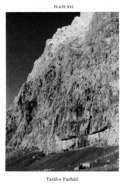
Tarāš-e Farhād (Plate XVI). This section of the cliff is of key importance in understanding the entire Sasanian building program at Bīsotūn. It is a chiseled rock face approximately 200 m wide and 30 m high, with a retaining wall ca. 150 m in front of it; it is thus the biggest such work in Iran and has interested writers from medieval geographers like Eṣṭaḵrī and Yāqūt (Schwarz, Iran IV, p. 452) to travelers and archeologists in modern times. Interpretations have differed widely: It has been considered the rear wall of a palace of Ḵosrow Parvēz prepared for a relief of Semiramis (Rawlinson); the site for a Sasanian king’s palace (King and Thompson, p. xxvi); a field prepared for an inscription of Darius (Jackson, pp. 187ff.); of the Achaemenid period (Herzfeld, 1920, p. 17; 1941, p. 221); of unknown date (Schmidt, 1953, I, p. 39; see also Golzārī pp. 378ff., fig. 286, and Huff, 1985, pp. 27-29, 44).
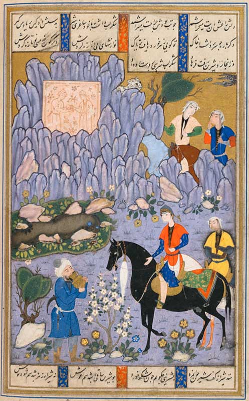
Local tradition, as reported in the 1960s and as noted earlier by Jackson (p. 188), attributes the work to Ḵosrow Parvēz’s architect Farhād, which points to the Sasanian period and prompts examination of Neẓāmī’s poem Ḵosrow o Šīrīn, begun about 1180. Neẓāmī mentions three great works of Farhād: the milk channel, the passage cut through the mountain at Bīsotūn, and the portrait of Šīrīn. Miniature paintings are particularly helpful in clarifying matters at Bīsotūn. The story of Farhād and Šīrīn was a favorite theme for miniatures, stucco work, and paintings on tiles and under glass from the 9th/15th to the 14th/20th century. This subject requires detailed study, on which the present writer has embarked in connection with a forthcoming publication on Bīsotūn. One of the most revealing works of art is a miniature of ca. 973/1575 (at Oxford), which depicts a meeting of Farhād with Šīrīn in front of the pool at Mount Bīsotūn; a slab carved with effigies of two lovers is set into the hillside, which is clearly identifiable as the great rock face (Plate XVII). Taken together, the poetry, the miniatures, and the data from examination of the site suggest that Farhād was the architect of the Sasanian works at Bīsotūn. The chiseled rock face must be the wall of his “passage through the mountain for twenty horsemen.” The milk channel, which is also often depicted in miniatures (e.g., Guest, fig. 48A, a miniature in The Freer Gallery of Art), is likely to have been the working channel on top of the cliff—an opinion in which G. Cameron concurred (oral communication). The notion of the “portrait of Šīrīn” may well have been evoked by the capitals showing Anāhīd and Ḵosrow Parvēz, which were certainly visible in the time of Neẓāmī and his informants, as they have never been buried under earth. The first writer to connect them with Šīrīn was ʿAbd-al-Karīm, in 1145/1741, probably relying on local tradition (Luschey, 1974, p. 141). References to the Sasanian remains in the literature of the early Islamic period apparently stirred people’s imaginations and inspired poetic compositions in later times. Although Neẓāmī never left his hometown, Ganja, and thus never saw Bīsotūn, he had access to information recorded by geographers in the 4th/10th century and passed on as part of the literary tradition. (Cf. also Soucek, 1974, pp. 27-52, where Farhād is discussed in connection with Ṭāq-e Bostān, but not with Bīsotūn.)
Study of the cliff face of Farhād from a different point of view was undertaken by the architect W. Salzmann. His researches included especially the risky examination and measuring of the work area above the cut-away section of the rock (pp. 110-34, figs. 6-14, with a plan of the entire cliff and its surroundings). He has considerably clarified the method of working and has calculated the volume of rock removed at approximately 40,000 m3 (p. 120). In attempting to reconstruct what was originally planned, he concluded that there was to be a huge terrace at a height of 30 m and an enormous ayvān hollowed out of the rock, probably on the same scale as the Ṭāq-e Kesrā at Ctesiphon, with reliefs on either side (fig. 21). This hypothesis is consonant with earlier theories suggesting a palace (Rawlinson) or fire temple built against the cliff; it is impossible to prove conclusively, however.
The dressed stone blocks on the hillside. These stones were noted by early European travelers but were not identified as Sasanian until the present writer was able to gather evidence. He found that they are of the same rock as the Tarāš-e Farhād and that they bear masons’ marks that match markings on Sasanian seals and are clearly of the same form as the masons’ marks on the Tarāš-e Farhād, the Gamašāb retaining wall, and the dressed stones in the Old Caravansary. The blocks, numbering several hundred, are found along the whole stretch of the hillside below the Tarāš-e Farhād as far as the ravine of Darius and beyond along the Parthian slope up to the Kurdish gravestones—a distance of more than 2,000 m (Luschey, 1974, pp. 129, 142, fig. 27; Salzmann, p. 132, n. 46; Golzārī, p. 380, fig. 282).
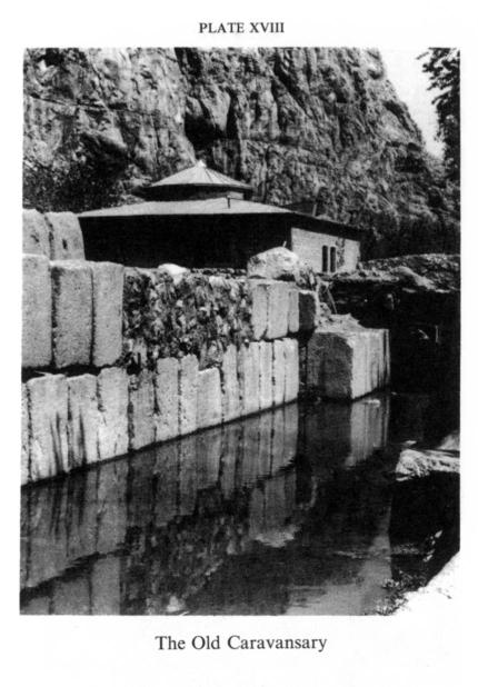
The Old Caravansary (Plate XVIII). This monument was not discovered until rather late, as the village has been built on top of it. Herzfeld saw no sign of it, though Flandin and Coste had marked a “mur antique” on their plan of Bīsotūn in 1840 (I, pl. 15). It is a square building, measuring ca. 80 x 80 m, with the entrance in the center of the front wall and three slightly (80 cm) projecting buttresses on each side. The walls are about 2 m thick. The front wall is built of massive stone blocks ca. 80 cm high, three courses of which are still standing at one point. There are traces of interior rooms built against the perimeter wall, eight on each side. The writer named this building Old Caravansary because of early travelers’ reports. Abel Pincon, the secretary for Sir Anthony Sherley’s embassy to Shah ʿAbbās I, mentions that in 1598 the group had had to spend one night in a ruined caravansary at Bīsotūn. Pietro della Valle stayed there in 1618 and Jean de Thévenot in 1664 (see Luschey, 1974, pp. 139ff. for full references).
To replace this Old Caravansary, the New Caravansary was built in 1092-96/1681-85. Excavation revealed that the stonework of the old building remains only in the massive perimeter wall, the entrance (which is 2.60 m wide), and in an internal partition wall parallel to the east facade. In the 14th century the upper parts of the partition walls were demolished, and the previously mentioned rooms built over their remains. Some 14th-century pottery was found in the fill above the old walls.
The construction date of the older building was for a long time in doubt. The monumental stone blocks still standing in the outer wall have the same shape and the same masons’ marks as the blocks on the hillside and in the retaining walls of the Tarāš-e Farhād and the Gamašāb and must therefore be recognized as Sasanian. The question is whether the building in which they were used was of Sasanian or early Islamic origin. I was at first inclined to accept a Sasanian date (Luschey, 1965, pp. 22f.; Golzārī, pp. 384ff., figs. 292-99, following Luschey; Luschey, 1974, p. 130, figs. 30, 33), citing analogies with late Roman fortifications on the Euphrates) but finally came to a different conclusion. One consideration was the inconsistency of the building’s orientation with the Sasanian north-south and east-west axes, another the fact that no Sasanian artifacts were found in it, the third—and most decisive—the nature of a small structure in the center of the courtyard. This structure is a mosque, measuring ca. 10 x 10 m and oriented toward Mecca. It is the oldest Iranian example of the mosque in the courtyard, which was to become an essential component of Anatolian caravansaries (K. and H. Erdmann, pp. 92ff., esp. p. 98). The orientation deviates by only six degrees from that of the modern village mosque nearby. The walls are of rubble concrete 2 m thick, the internal area ca. 6 m2, and the doorway 1.10 m wide.
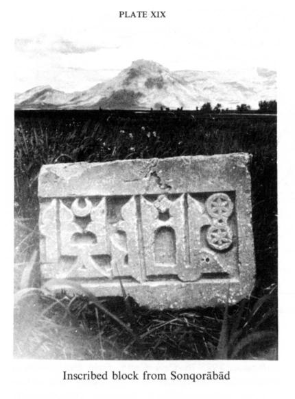
Local people pointed out a stone block (Plate XIX) inscribed with the Islamic profession of faith in the Sonqorābād plain 4 km from Bīsotūn (Gropp and Nadjmabadi, p. 209; Luschey, 1974, p. 137, fig. 38; Golzārī, p. 397, fig. 367). From a combined study of this stone and the courtyard mosque the writer concluded that the stone may have come from above the doorway. There has never seemed any question that this fine inscription is from the Buyid period (4-5th/10-11th centuries). It may well have come from the same workshop as the stone blocks with Kufic inscriptions at Sarmāj, the fortress built by the Kurdish prince Ḥasanūya/Ḥasanwayh (d. 368/979), and eventually captured by the Saljuq Ṭoḡrel Beg in 441/1049 (Le Strange, Lands, p. 189). Ḥasanūya was an active builder, as the walls of his fortress at Sarmāj show; he is also reported to have built a large mosque at Dīnavar. It therefore seems reasonable to suggest him as the builder of the Old Caravansary. Probably it was not a caravansary at that time but a fortified military outpost, close to the spring and not far from the Sasanian bridge and the road to Taḵt-e Šīrīn and Sarmāj. Such a garrison would have been useful for blockading the old caravan route that passed through Bīsotūn from Kermānšāh to Hamadān.
After the end of the German campaign of excavations at Bīsotūn (1963-67), and against the express wishes of the writer, the modern village was demolished. Subsequently, in 1975, further excavations in the Old Caravansary were conducted by M. Rahbar. He found a second entrance ca. 3 m wide on the west side (without steps) and barricade walls extending to the hillside (plan in Kleiss and Kīānī). Finds of artifacts were, however, evidently scarce (see Cinquième Symposium Annuel, p. 31). Photographs of Bīsotūn after the demolition of the village have been published by Masʿūd Golzārī (figs. 313, 315).
The Mongol building. This structure was discovered by the writer in a reconnaissance along the bank of the Gamašāb. A mound of debris could be seen there on a site roughly 25 m wide and 30 m long (22 x 30.7 m, as measured by Kleiss), and the presence of 14th-century potsherds and fragments of cut brick immediately suggested a Mongol building. This hypothesis was confirmed in subsequent excavation work by L. Trümpelmann and proved conclusively by Kleiss in 1966-67 (Golzārī, p. 400, with plan). The building was a sort of kiosk facing the river, decorated on the outside with cut bricks comparable to those on the Gonbad-e ʿAlawīān at Hamadān and the Mostanṣerīya in Baghdad. The interior rooms were decorated with glazed bricks.
In this connection Qāżīzāda, the village headman, related that a royal town named Solṭānābād-e Jamjamāl had once existed in the same part of the plain, which accords with the report of Ḥamd-Allāh Mostawfī Qazvīnī (writing in 741/1340) that the īl-ḵān Oljāytū/Öljeytü (703-17/1304-17) had erected buildings there (Schwarz, Iran, p. 487; Golzārī, pp. 398ff., figs. 310ff.).
The Safavid caravansary and bridge. The Safavid caravansary was built by Shaikh ʿAlī Khan Zangana, the same man who destroyed a large part of the relief of Mithridates to make way for his waqf inscription. This handsome structure, built in 1092-96/1681-85, is of brick on dressed stone socles and measures ca. 80 m wide and 90 m long; the interior courtyard is 50 x 52 m and has four ayvāns. The adjacent sleeping rooms are vaulted, and there is vaulted stabling behind. This plain, monumental building is one of the larger Safavid caravansaries still in a good state of preservation, though now lacking its original entrance pavilion. It was thoroughly surveyed by Kleiss in 1966-67 (1970, pp. 289-308, pls. 127-30; Golzārī, pp. 404-13, figs. 315-26).
The old caravan track over the plain to Kermānšāh is still discernible; it comes from the bridge at Sarpol-e Šāh but follows a different route from that of the modern highway, which runs closer to the foot of the mountains and then makes a 90-degree turn in the direction of Kermānšāh. The four-arched bridge was built in conjunction with the caravansary; it contains Sasanian stone blocks probably taken from the nearby hillside. As a work of engineering it is simple but typical of the period. It too was surveyed by Kleiss in 1966-67, but his report remains unpublished (Golzārī, pp. 402ff., fig. 313).
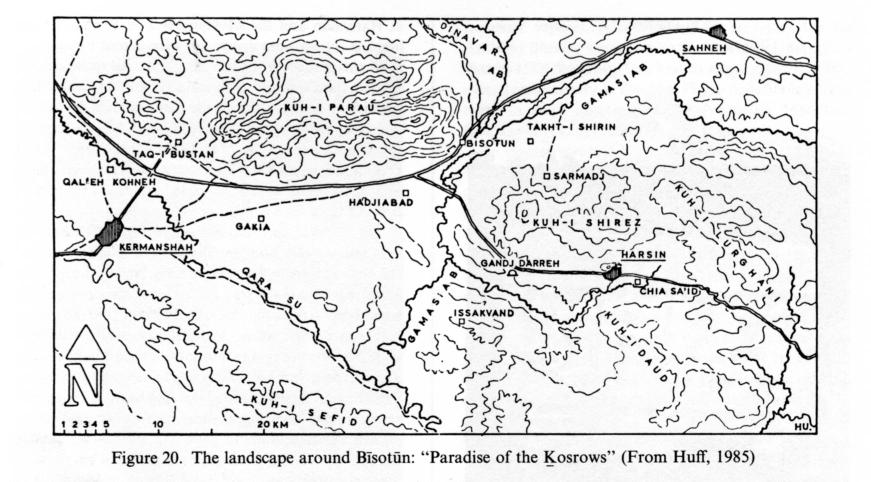
The surrounding district and the “Paradise of the Ḵosrows” (Figure 20). Bīsotūn must not be viewed simply as an isolated site containing historical monuments. It formed instead an integral part of a larger district, which was particularly well defined in the Sasanian period, as can be seen from other contemporary remains found throughout the entire area.
The most important is, of course, Ṭāq-e Bostān (q.v.), 30 km away, which is also connected with Ḵosrow II (Herzfeld, 1920, pp. 57ff., pls. 27-65; Erdmann, pp. 1ff.; Fukai and Horiuchi; see also Luschey, 1975, p. 113, pls. 25-32).
In the immediate neighborhood of Bīsotūn is Taḵt-e Šīrīn (q.v.), 10 km away, where stone blocks and debris from a collapsed building can be seen. A sloping terrace at Sarmāj, somewhat farther south, was reported by medieval authors to be the place where Ḵosrow II received envoys from China and Rome (Schwarz, pp. 485ff.). An inclined wall of large closely set blocks discovered by the writer in 1962-63 is probably to be identified with this terrace (Trümpelmann, pp. 11ff.). This Sasanian terrace (called dokkān by the Arab geographers) was later enclosed within the walls of Ḥasanūya’s castle. As already mentioned, the writer believes that this Kurdish prince of the Buyid period also built the Old Caravansary at Bīsotūn. In view of the importance of Sarmāj for both Sasanian and Buyid history, a full investigation was planned, but it could not be carried out.
Farther inland, at Harsīn, a cliff face has been hewn away in the same technique as at the Tarāš-e Farhād, though it is considerably smaller (Huff, 1985, pp. 15ff., pls. 1-22).
There is also a series of find spots on the old caravan route from Bīsotūn to Kermānšāh. At Ḥājīābād, Herzfeld saw some Sasanian capitals and plinths (1920, p. 115, fig. 29; Luschey, 1968, p. 132, fig. 3, pl. 53.3-4) . The bridge over the Qarasū at Sarpol-e Šāh contains plundered Sasanian capitals (observed by the writer in 1962 but not yet published). In Kermānšāh itself a number of Sasanian capitals can still be seen, and their distribution suggests that they are remains of a palace (Luschey, 1968, pp. 129ff., figs. 4-5, pl. 53.6). The founder of this city is traditionally said to have been Bahrām IV (r. 389-99). The capital found at Qaḷʿa-ye Kohna by Herzfeld in 1916 (1920, pp. 115ff., figs. 30-31, pl. 60) and rediscovered by the writer (Luschey, 1968, pp. 129ff., fig. 2, pl. 52.1-2) probably cannot be taken as evidence of a Sasanian building there; very likely it was brought there from Kermānšāh.
The evidence thus suggests a distinct cultural area on this fertile plain, for which C. Ritter (p. 975) suggested the name “Paradise of the Ḵosrows”; the original name may be Nisaya, as in Darius’s inscription (DB 1.58, Kent, Old Persian, pp. 118, 120, 194).
Bibliography
R. Borger and W. Hinz, “Die Behistun-Inschrift Darius’ des Grossen,” in Texte aus der Umwelt des Alten Testaments I: Historisch-chronologische Texte I, 1984, pp. 419-50.
Cinquième Symposium Annuel de la Recherche Archéologique en Iran . . ., 1975-76.
C. S. Coon, Cave Exploration in Iran 1949, Philadelphia, 1951.
Idem, The Seven Caves, London, 1957.
K. Erdmann, “Die Kapitelle am Taqi Bostan,” MDOG 80, 1943, pp. 1-42.
Idem and H. Erdmann, Das anatolische Karavanseray des 13. Jahrhunderts II-III, Berlin, 1976.
A. Farkas, Achaemenid Sculpture, Istanbul, 1974.
Idem, “The Behistun Relief,” in Camb. Hist. Iran II (1985), pp. 828-30.
E. Flandin and P. Coste, Perse ancienne, Paris, 1841.
F. Fukai and H. Horiuchi, Taq-i Bustan I-IV, Tokyo, 1969-84.
R. Ghirshman, Iran, Paris, 1954. Idem, Parthes et Sasanides, Paris, 1962.
M. Golzārī, Kermānšāhān-Kurdestān, Tehran, I, 1978 (containing a reproduction of Luschey’s studies and photos).
G. Gropp and S. Nadjmabadi, “Bericht über eine Reise in West- und Südiran,” AMI, N.S. 3, 1970, pp. 173-230.
G. D. Guest, Shiraz Painting in the 16th Century, Washington, D.C., 1949.
ʿA. Ḥākemī, “Mojassama-ye Herkūl dar Bīsotūn,” Majalla-ye bāstānšenāsī 3/4, 1338 Š./1959-60, pp. 3-12.
E. Herzfeld, Am Tor von Asien, Berlin, 1920. Idem, Iran in the Ancient East, London, 1941.
W. Hinz, “Die Entstehung der altpersischen Keilschrift,” AMI, N.F. 1, 1968, pp. 95-98.
D. Huff, “Das Felsrelief von Qir (Fars),” AMI 17, 1984, pp. 221-47.
Idem, “Harsin,” AMI 18, 1985, pp. 15-44.
A. V. W. Jackson, Persia Past and Present, New York, 1909.
L. W. King and R. C. Thompson, The Sculptures and Inscription of Darius the Great on the Rock of Behistan in Persia, London, 1907.
W. Kleiss, “Zur Topographie des Partherhangs in Bisotun,” AMI, N.S. 3, 1970, pp. 133-68.
Idem, “Das safavidische Karavanserei von Bisutun,” AMI, N.S. 3, 1970, pp. 289-308.
Idem and M. Y. Kīānī, Fehrest-e kārvānsarāhā-ye Īrān I, Tehran, 1362 Š./1983.
H. Luschey, “Ausgrabungen in Bisutun,” Anjoman-e Farhang-e Īrān-e Bāstān [Ancient Iranian Cultural Society], Bulletin 2/1, 1965, pp. 19-41 [in Persian and German].
Idem, “Studien zu dem Darius-Relief in Bisutun,” AMI, N.F. 1, 1968, pp. 63-94.
Idem, “Der Löwe von Ekbatana,” ibid., pp. 116-22.
Idem, “Zur Datierung der sasanidischen Kapitelle aus Bisutun und des Monuments vom Taq-i Bostan,” ibid., pp. 129-47.
Idem, “Bisutun, Geschichte und Forschungsgeschichte,” Archäologischer Anz. 89, 1974, pp. 114-49.
Idem, “Zum Problem der Stilentwicklung in der achämenidischen und sasanidischen Reliefkunst,” Iranica Antiqua 11, 1975, pp. 113-33.
O. Mann, “Archäologisches aus Persien,” Globus 83, 1903, p. 327.
S. A. Matheson, Persia. An Archaeological Guide, 2nd ed., London, 1976, Ger. tr., Stuttgart, 1980.
H. C. Rawlinson, “Notes on a March from Zohab . . . to Khuzistan,” JRGS 9, 1839, p. 41.
C. Ritter, in Erdkunde von Asien IX/3, Berlin, 1940.
W. Salzmann, “Die "Felsabarbeitung und Terrasse des Farhad" in Bisutun: Ein spätsasanidisches Monument,” Archäologischer Anz., 1976, pp. 110-34.
E. F. Schmidt, Flights Over Ancient Cities of Iran, Chicago, 1940.
Idem, Persepolis I, Chicago, 1953.
F. Sarre and E. Herzfeld, Iranische Felsreliefs, Berlin, 1910. D. Schlumberger, Der Hellenisierte Orient, Baden-Baden, 1969, p. 28.
Idem, “Parthian Art,” in Camb. Hist. Iran III/2 (1983), pp. 1027-54.
U. Seidl, “Ein Relief Dareios’ I in Babylon,” AMI, N.S. 9, 1976, pp. 125-30.
D. Stronach, “Excavations at Tepe Nush-i Jan,” Iran 16, 1978, pp. 1-11.
Idem, “Archaeology, ii,” in EIr. II/3 (1986), pp. 288-96.
P. P. Soucek, “Farhad and Ṭāq-i Būstān: The Growth of a Legend,” in Studies in Art and Literature of the Near East in Honor of Richard Ettinghausen, ed. P. J. Chelkowski, New York, 1974, pp. 27-52.
L. Trümpelmann, “Zur Entstehungsgeschichte des Monuments Dareios I von Bisutun und zur Datierung der Einführung der altpersischen Schrift,” Archäologischer Anz., 1967, pp. 281-98.
L. Vanden Berghe, L’archéologie de l’Iran ancien, 1959.
[T. Kawami, Monumental Art of the Parthian Period in Iran, Acta Iranica 26, Leiden, 1987.]