

ARḠANDĀB, a river in the south of Afghanistan, the biggest tributary of the Helmand (q.v.); also the name of a dam and two districts in Afghanistan. The present name, in the form Āb-e Arḡand, is attested from the 7th/13th century (Jūzǰānī, Ṭabaqāt II, p. 141). It replaced an old name which was Haraxᵛaiti in Avestan and became Arachôtos in the geography of Ptolemy, Roḵḵad-rūd in the Tārīḵ-eSīstān, and by metathesis Ḵorad-rūy in the geography of Moqaddasī (p. 304).
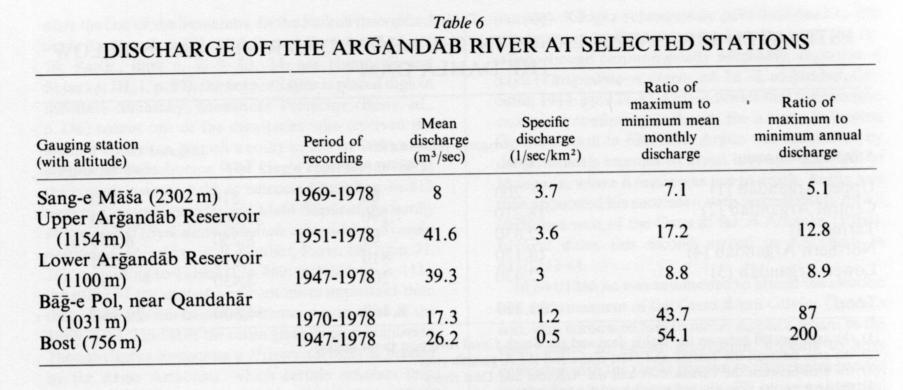
The Arḡandāb originates at about 3,900 m above sea level in the Kūh-e Ṣafīd, west of the Nāvor high plain (see Dašt-e Nāvor), and after a course of 562 km joins the Helmand at Qaḷʿa-ye Bost (altitude 749 m). Its basin covers 52,955 km2 in Afghan territory, to which must be added a small area in Pakistan (east of Spīn Bōldak) around the upper course of its main tributary, the Dōrī (q.v.) river. The hydrology of the Arḡandāb is now fairly well known. Table 6 gives the gist of the available data. In respect of discharge, three distinct sections in the river’s course can be identified. The upper Arḡandāb is perennial with a mountain régime mainly determined by the snowmelt in the Hazāraǰāt high lands; its peak flows occur in April and May. Lower down, the influence of run off from rainfall is more marked and the peak flows are recorded in March and April; as the river approaches the Qandahār oasis, its average discharge shows a considerable decline due chiefly to diversion of water for irrigation (see below). In the lowest section, despite a perceptible rise in the average discharge due to the inflow from the Dōrī, which drains part of the Solaymān mountains, seasonal and annual irregularity is greatest, periods of low water are longest (e.g., eight months recorded from 21 May 1971 to 16 January 1972 with no flow at all), and floods most impressive (1698 cubic meters per second recorded at Bost on 30 January 1950).
The river, with its abundant water (the original meaning of its Avestan name, see AirWb., col. 1788) has a great impact on the economy of the arid southern Afghanistan. It is the main factor which has made possible the agriculture of the Qandahār oasis and therewith the prosperity of the city, which does not, however, lie on its banks. Local tradition maintains that a complex and well-designed network of irrigation canals existed in the 12th/18th century, when Qandahār was the capital of Aḥmad Shah Dorrānī’s empire; but this could only provide seasonal irrigation, given the river’s natural discharge being so irregular and so scanty in the summer months. Perennial irrigation only became possible in recent times, thanks to the construction of a reservoir dam at Dahla, 34 km northeast of Qandahār. The dam was built between Jowzā, 1329 Š./June, 1950 and Jadī, 1330 Š./January, 1952 with American aid as part of the large-scale regional development project of the Helmand-Arḡandāb Valley Authority (HAVA). Its height above the river bed is 50 m and its west length is 540 m. Part of the river’s high cold season water flows is stored in the reservoir, a lake covering about 30 km2, and released to supplement the low hot season flows. The dam is not equipped for hydroelectric generation. Numerous old-style irrigation canals on both banks of the river have benefited from the partial regularization of the discharge. Between the Dahla dam and the Dōrī confluence there are twenty-three such canals with a total capacity of 18.4 m3 per second on the right bank and thirteen with a total capacity of 5.7 m3 per second on the left bank; below the confluence there are fifteen and eleven canals respectively, with ungauged capacities. The construction of the dam has also prompted some remodeling of the old irrigation network of the Qandahār oasis, mainly in its eastern part. The key component of the new system is a large canal on the left bank, called the South Canal, which diverts from the river 18 km below the dam; it has a capacity of 42.5 m3 per second and is 74 km long. As a result of this reorganization, 24 km of old canals which were rendered useless have been filled up and put under cultivation.
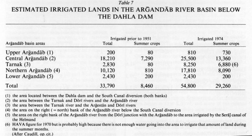
The scheme has yielded benefits which are far from negligible. Table 7 shows that the introduction of perennial irrigation has (in broad terms) made possible a sixty-two percent increase in the cultivated area in the Qandahār oasis and a remarkable development of summer crops, particularly orchards and vineyards (apricots, pomegranates, grapes and the cultivated area rose three- and-a-half fold between 1951 and 1974). These advances, however, have not been achieved without consequential risks. In the first place, perennial irrigation has raised the level of the ground water table, causing drainage problems and even marsh conditions in some areas; the construction of open drainage canals (about 100 km between 1961 and 1969) has not wholly obviated this danger. Secondly, the heavy suspended sediment in the Arḡandāb’s waters is silting up the Dahla reservoir at a rapid rate. The reservoir’s original storage capacity of 479 million m3 had fallen to 403 million in 1976, i.e., suffered an average annual loss of 65 percent. At this rate the reservoir will lose half of its storage capacity by the year 2040. The resulting prospective decline in summer irrigation potential poses a long-term threat to the Qandahār oasis.
Bibliography:
On the problems of identifying the ancient names for the Arḡandāb, see W. W. Bartol’d, Istoriko-geograficheskiĭ obzor Irana, St. Petersburg, 1903, repr. in Sochineniya VII, Moscow, 1971, p. 91; tr. S. Soucek, An Historical Geography of Iran, Princeton, 1984, pp. 73, 74.
G. Gnoli, Zoroaster’s Time and Homeland, Naples, 1980.
P. Bernard, “Un problème de toponymie antique dans l’Asie Centrale: les noms anciens de Qandahar,” Studia Iranica 3/2, 1974, pp. 171-85; repr. in Afghanistan 28/1, 1354 Š./1975, pp. 1-15.
On hydrology, see Ministry of Water and Power, Hydrological Yearbook 1961-1975, Part II-4B (Arghandab river basin), Kabul, 1976, and Hydrological Yearbook 1976-1978, Part II (Rivers of Helmand Basin: Ghazni and Helmand), Kabul, 1982.
On changes due to the construction of the Dahla dam, see several USAID reports, of which the most informative are S. Caudill, Helmand Arghandab Valley: General Overview, Project Areas, Past and Present Irrigation, Cost Estimates for Completion, Kabul, 1974, and USAID, Helmand River Basin Soil and Water Survey Study Report, Part I, n.p., 1976.
For the silting of the Dahla dam, see O. D. Mort, R. R. Ambayec, and R. J. Haase, Hydrographic and Sedimentation Survey of Arghandab Reservoir, Lashkargah (Afghanistan), 1973.
(D. Balland)
Originally Published: December 15, 1986
Last Updated: August 12, 2011
This article is available in print.
Vol. II, Fasc. 4, pp. 398-400