

ANTI-ALBORZ, the highland between Tehran and Semnān on the southern flank of the central Alborz range. The name, which has no equivalent term in Persian, was given to the region, on the analogy of the Anti-Atlas, by the French geologist André Rivière (“Contribution à l’étude géologique de l’Anti-Elbourz,” Bulletin de la Société Géologique de France, 1936, pp. 277-98). This arid highland of middling elevation is a no-man’s-land, markedly different in respect of both physical features and human occupation from the high valleys of the Alborz, the cultivable piedmont areas, and the Tehran region. It is a marginal zone with an ethnically heterogeneous population and an economy wholly dependent on Tehran, of which it is now a sort of outer suburb.
Physical geography. The Anti-Alborz has a length of 170 km and breadth of from 30 to 40 km, and is bounded on the south by the Tehran-Semnān highway (the Khorasan road), on the east by the pass of Bašm. The geology is clearly distinct from that of the central range; in this respect, some authorities define the Anti-Alborz region as extending to Šāhrūd (N.I.O.C., Geological Map of Iran, 1/1000,000, sheet 2, North Central Iran, Tehran, 1977). It consists of an east-west anticline with a cretaceous-jurassic core, but its two sides lack symmetry. The north side, composed of eocene volcanic tuffs (Karaǰ formation), has long, regular slopes and high plateaus (around Fīrdeh). The summit ridge, which seldom falls below 2,400 m (Qara-āḡāč heights south of Damāvand), is not craggy but very smooth. Further down, the northern slopes merge into the elevated plains of Jābān and Fīrūzkūh (altitude 2,000 m). The climate and vegetation resemble those of the central Alborz; severe cold in winter, steppe with bushes of the hawthorn (Crataegus) or barberry (Berberis) genera and occasional vestiges of juniper (Juniperus excelsa) or cypress (Cupressus sempervirens) forest.
In contrast, the south side is a barren and hostile wall overlooking the Varāmīn-Garmsār plain (altitude 900 m). The formations of oligo-miocene detritus have a thickness of 5,000 m and are very deeply dissected by erosion. The pliocene conglomerates of Hazārdara in the south and the colored marls and clays of the Upper Red formation further north have been carved into cuestas and bad lands. Salt and gypsum are present everywhere. The vegetation is very poor and akin to that of the kavīr (e.g., the Pistacia genus). East of the Ḥablarūd, limestones of the Qom formation give an even sharper relief (Kūh-e Golnāb, 3,311 m). To the west, the south of Tehran is overlooked by the crystalline limestone massif of Sepāya (2,251 m). This mountain and the adjacent Jāǰ-rūd valley, once a royal hunting preserve and now a national park, were kept clear of people and flocks from the late 18th century onward; the area thus has a particularly rich fauna, (birds, moufflons, wild bears, mountain goats, even panthers) and a less poor flora than elsewhere (bushes of the Astragalus genus such as katīra and gavan, tamarisk trees in the ravines).
Three great clefts cut through the Anti-Alborz. They have been excavated by streams which, since they generally flow from springs in the central range, have substantial but always very irregular discharges. These streams (the Jāǰ-rūd and its tributary, the Tār-rūd, the Zam-rūd in the center, the Ḥabla-rūd and its tributary the Dalī-čāy in the east) have the tendency to cause severe flooding when in spate. The Ḥabla-rūd, which debouches in the Garmsār plain, is the most substantial with an average annual discharge which has varied between 133 and 501 million cubic m. The valleys are very shut in, and have some spectacular gorges. The Anti-Alborz is an inhospitable region, difficult of access, too hot and short of water for summer use (as a yeylāq) and too cold for winter use (as a qešlāq). It is a highland of only marginal value.
Human occupation. The Anti-Alborz is not one of Iran’s historical regions. As the northern fringe of the provinces of Ray and Qūmeš, it formed a frontier zone between the Persian-speaking populations of the plains, who were vulnerable to invaders and plunderers, and the Caspian-type populations of the central Alborz valleys. Mentions of this long deserted highland in historical writings are rare (see ʿA. R. Ḥaqīqat, Tārīḵ-e Semnān, Semnān, 1352 Š./1973; H. Karīmīān, Qaṣrān, 2 vols., Entešārāt-e Anǰoman-e Āṯār-e Mellī 137, Tehran, 1356 Š./1977). The only notes made by European travelers in the 19th century are about the royal hunting preserve (J. B. Feuvrier, Trois ans à la cour de Perse, Paris, 1906). The Ḥabla-rūd valley, inhabited since ancient times and once part of a direct caravan route from Isfahan to Sārī, contains a few archaeological remains: Mongol tomb towers and a Safavid bridge at Anzehā (W. Kleiss, “Karawanwege in Iran,” AMI 10, 1977, pp. 301-03, maps). This stretch may perhaps have been the “Caspian Gates” of Alexander’s campaign.
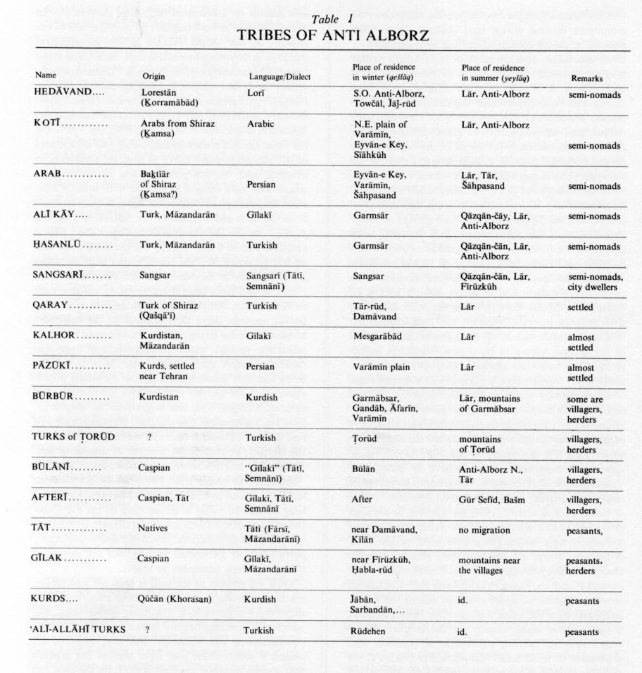
After Tehran had become the capital, these deserted mountains became crown land (ḵāleṣa). From then onward, nomadic groups which had been deported or taken as hostages were settled in the Anti-Alborz so that they might remain under the eye of the nearby royal authority (J. R. Perry, “Forced Migration in Iran during the Seventeenth and Eighteenth Centuries,” Iranian Studies 8/4, 1975, pp. 199-215). Thus the Anti-Alborz has been peopled with a great variety of ethnic elements from different provinces of the country. The presence of small nomadic groups close to Tehran in the Varāmīn plain is mentioned by travelers (A. Chodzko, “Une excursion aux Pays Caspiennes en 1835,” Nouvelles Annales des Voyages 23, 1850, pp. 280-305). For particulars, see Table 1. These small groups of shepherds, totaling no more than 3,000 families, soon colonized the lands on their migration routes, which hitherto had hardly been used at all by the peasants. Villages were put up by sedentarized nomads with speed and dispatch, and often on difficult sites (e.g., Garmābsar, Būlān, Ṭorūd). From the other direction, demographic pressure impelled the long established Gīlakī peasant-herdsmen of the valleys of the south side of the central Alborz to build new villages in higher parts of the Anti-Alborz hitherto used only for summer pasture (yeylāq) and even in places on its southern slope which were easily accessible from the north (e.g., Rāmadeh). The Tāt people occupying the piedmont areas did not take much interest in the inhospitable highland, but extended their tillage and lands toward the edge of the kavīr. Thus the dissymmetry of the Anti-Alborz facilitated the “conquest” of the Alborz by peoples of Caspian stock (B. Hourcade, “Migrations de travail et migrations de loisir dans l’Elbourz de Téhéran,” Revue de Géographie de Lyon 3, 1978, pp. 229-40). In the 20th century the folk who make their living from animal husbandry have strengthened their hold; people from Aftar and, above all, Sangsar have seized, often by force, extensive grazing grounds and numerous hamlets around Fīrūzkūh. From 1950 onward, the colonization movement gathered speed after the sale of the ḵāleṣa lands and then the Land Reform. The richest nomads bought arable lands, mainly on the northern slope where rain-fed (deymī) cultivation is possible, and proceeded to build small camp-hamlets (mazraʿa) on these lands; they recurrently visited the hamlets, which lay on their migration routes, and sometimes had the lands tilled and sown in spring or autumn. Hamlets of this type were created by Hedāvand nomads in the west and by ʿAlī Kāy and Ḥasanlū nomads from Garmsār in the east.
In 1976 the Anti-Alborz had approximately 27,000 inhabitants and thus a much lower population density than the central Alborz, despite the latter’s harsh winter climate. The settlement pattern is one of dispersal in numerous small villages; in 1966, 55 inhabited places had more than 20 families each and 145 had less. There are no real market villages. The small towns of Damāvand, Fīrūzkuh, Eyvān-e Key, Garmsār, and Sorḵa all lie outside the highland. Moreover the population fluctuates greatly on account of migration movements. In winter the Anti-Alborz empties; 20 to 30 percent of the families of the Gīlakī villages follow an ancestral tradition in departing to work in Sārī, Bābol, and other towns of Māzandarān (X. de Planhol, “Un haut pays du versant aride de l’Alborz: le Lārīdjān (haute vallée du Harāz),” Recherches sur la géographie de l’Iran septentrional, Centre National de la Recherche Scientifique, Mémoires et documents 9/4, Paris, 1963, pp. 17-36). On the other hand, Persian-speaking and Tātī inhabitants of the piedmont areas move to summer residences in irrigated and orchard-planted parts of the valleys, where they have bought lands and built usually scattered houses (e.g.. at Zarrīndašt, Aǰān, Kīlān). Nomads from Garmsār and Sangsar use the Anti-Alborz as their yeylāq, while the Hedāvand, Kotī, and Būlānī nomads, who in winter occupy the southern slope and do not go down into the plain, spend their summers around Lārīǰān in the central Alborz. Pastoralists from Fīrūzkūh and from large sheep-breeding villages, such as Garmābsar, Aftar, and Ṭorūd, as well as certain Būlānī nomads, drive their animals to the neighborhoods of hamlets in the middle altitude zone (wrongly called the yeylāq), where encampments or even real summer villages, such as Gūr sefīd, have come into being and now accommodate almost the whole population. In view of the proliferation of hamlets and summer villages, and the migrations of shepherds, laborers, and tourists, this marginal highland cannot be said to have a homogeneous and stable population. All the highland’s inhabitants, whether of nomad or peasant origin, now lead some form of semi-nomadic life.
Economy. It is only since 1950 that the Anti-Alborz has been crossed by a road (Kītān to Eyvān-e Key). The long Ḥabla-rūd valley is served only by the Garmsār-Gorgān line of the Trans-Iranian Railroad, but the line has given rise to considerable activity and employment, particularly at Zarrīndašt station. All the inhabited villages are now accessible by tracks.
Only 2.5 percent of the land is used for agriculture, mainly for orchards which have been steadily gaining importance in the valleys. Upstream, apples, pears, and sweet and sour cherries are grown, and downstream, pomegranates and almonds. Midway, apricots are almost a monoculture and have become the region’s best-known product; the fruit is dried on the spot and sold in Tehran under the name qeys¡ī, mainly for export. Production of vegetables, particularly cucumbers, and lumber, principally poplar, supplements the quite high incomes of the cultivators, who have given up deymī grain growing on lands where mechanization is impracticable. On the other hand, the nomads, by making systematic use of tractors, have expanded wheat and barley cultivation on the gentle slopes on the northern side, mainly in the area south of Damāvand.
In the Gīlakī villages, the traditional combination of animal husbandry and agriculture is in decline; the flocks are now hired out to nomads or specialist breeders. Nevertheless animal husbandry remains the dominant activity throughout this highland, where in summer approximately 150,000 sheep and goats and 5,000 cattle are grazed. In winter large flocks are brought down to the plain but most are kept near the villages in special areas well away from the houses, either in long dung-covered sheds (čaft) or in underground pens (kohol) which often have fodder storage barns on top (e.g., at Fīrūzkūh and Mozdārān). On the southern slope, the Hedāvand and Kotī nomads have become sedentary and live in rudimentary hamlets with southerly exposures (e.g., Pāčālak, Neyak, Kūrōš); but these are gradually being abandoned for more modern and solidly built villages close to the roads (e.g., Emāmak, Towčāl). The lack of fodder, all of which has to be brought in, and the meagerness of the pastures make the animal husbandry very dependent on market and price trends, i.e., on Tehran. Craft industries are negligible; only the medium-quality carpets and the tent cloths of goat hair and white wool woven by some of the Garmsār nomads deserve mention.
Finally, the Anti-Alborz region has met the needs of nearby Tehran for sites for pollution-generating activities, and industries, such as garbage dumping and quarrying. There are chalk quarries and lime kilns at Ḥātemābād, cement factories at Bāḡ-e Komeš and Ray with associated quarries, plaster factories, and gypsum mines at Kūh-e Ara, Sarān, Kūroš, and Mesgarābād (Tehran’s oldest gypsum mine), and a silica sand quarry at Fīrdeh with a treatment plant at Fīrūzkūh. The explosives factory at Pāṛčīn on the lower course of the Jāǰ-rūd is by far the biggest industrial undertaking in the region with 1,000 employees; it has grown steadily and helped to sedentarize the nomads by providing work and very good wages in close proximity to their camps.
See also ALBORZ.
Bibliography:
See also B. Hourcade, “L’Anti-Alborz, un espace marginal aux portes de Téhéran,” Revue Géographique de l’Est 12/1-2, 1982, pp. 61-97.
Idem, “Kūč wa eqteṣād-e šabānī dar dāmanahā-ye ǰonūb-e Alborz,” Īlāt o ašāyer, Ketāb-e āgāh 3, Tehran, 1362 Š./1983, pp. 130-45.
(B. Hourcade)
Originally Published: December 15, 1986
Last Updated: August 5, 2011
This article is available in print.
Vol. II, Fasc. 2, pp. 116-119