

ALBORZ
iii. Geography
The Alborz mountains form the central part of the northern arc of mountains in Iran, which extend between the mountains of Armenia in the west and those of the Hindu Kush in the east (Figure 30a, Figure 30b). It separates the Aralo-Caspian depression in the north (-26 m) from the central Iranian uplands to the south (1,100-1,500 m). This high range forms an almost continuous wall, broken only by narrow defiles; it is separated from the mountains of Ṭāleš in the northwest by the deep valley of the Sefīd-rūd and linked to the mountains of Khorasan and the Kopet-Dag (Qobba Dāḡ) range in the east by the heights of Jāǰarm. It constitutes a climatic and ecological barrier of the first importance in the geography of Iran; the northern slopes, rising from the plains of Gīlān and Māzandarān, contrast sharply in their physical and human landscapes with the southern slopes, which are already part of Iran’s arid zone.
Relief. The Alborz chain, a little more than 500 km long and 60 to 120 km wide, forms a crescent open to the north. The western part, between the valley of the Sefīd-rūd and the Kandovān pass, has a fairly regular configuration: Three parallel ranges run for 180 km from west-southwest to east-northeast and then converge to form the mighty Taḵt-e Solaymān, a massif on the Alpine pattern; its crests exceed 4,000 m on a base of more than 30 square km (ʿAlam Kūh, 4,850 m). In the southern range, dominating the piedmont, the mountains of Qazvīn and Ṭālaqān are of medium altitude (2,800 m) but with some high passes (2,400 m) that help to isolate the long, deep valley of the Šāh-rūd, consisting at its source of the Alamūt and Ṭālaqān valleys; these are separated by the Kūh-e Alborz (4,056 m), which has given its name to the entire chain. To the north of the Šāh-rūd, the central range with its sheer walls rises from west to east (Kūh-e Varīnak, 3,395 m; Kūh-e Sīāh Lān, 4,175 m). In the north, the mountain range that dominates the Gīlān plain is broken up into massifs of unequal altitudes (Kūh-e Darfak, 2,698 m; Kūh-e Sūmām, 3,620 m) by small rivers that cut across it to descend toward the Caspian (Pol-rūd).
The central Alborz, between the Kandovān and Gadūk passes, reaches a width of 120 km and constitutes the highest tract of the chain. Its topographic structure is similar to that of the western region: In the center the axial range rarely drops below 3,500 m (Kūh-e Kahār, 4,108 m; Qolla-ye Now, 4,375 m; Āzād Kūh, 4,355 m; Kūh-e Dīv-e Sīāh, 4,318 m). All these peaks are dominated by the majestic cone of Damāvand, the highest elevation in Iran and in the Middle East, with an altitude (estimated, as are all altitudes given here) of 5,678 meters. To the east of the Harāz valley the mountains of Fīrūz Kūh rarely exceed 4,000 meters (Kūh-e Pašūra, 3,925 m; Kūh-e Mīšīn-e Marg, 4,022 m). To the south of this central zone some narrow and very high ridges (Towčāl, overlooking Tehran, 3,970 m; Kūh-e Šāhnešīn, 4,076 m) dominate the dry piedmont, where powerful torrents (Karaǰ, Jāǰ-rūd, Ḥabla-rūd) have left huge alluvial cones. As in the western Alborz, this southern range forms the watershed. Between Tehran and Semnān the Anti-Alborz massif is a zone of medium-sized mountains and hills honeycombed with ravines (Hezārdarra; A. Rivière, “Contribution à l’étude géologique de l’Anti Elbourz,” Bulletin de la Société Géologique de France, 1936, pp. 277-98; J. Dresch, “Le piémont de Téhéran,” in P. Bout et al., Observations de géographie physique en Iran septentrional, Mémoires et documents CNRS 8, Paris, 1961, pp. 86-101); it is joined to the southern flank of the chain and isolates the high interior plains of Damāvand and Fīrūz Kūh. On the northern flank, the eastern extension of the Taḵt-e Solaymān massif, the Kūh-e Malek Češma range north of the Nūr valley (Kūh-e Var-e Vašt, 4,008 m), forms a long, regular ridge overlooking the small massifs and high basins (Koǰūr) of the mountains of Māzandarān.
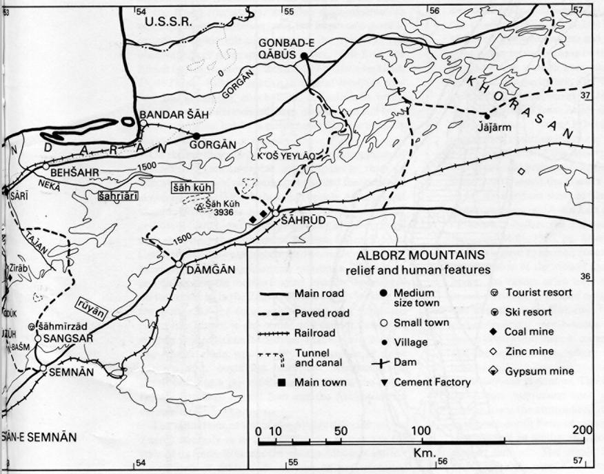
To the east of a line drawn between Semnān and Sārī, the Alborz has a different physiognomy. It runs from west-southwest to east-northeast, but it is narrower (60-80 km) and, except for the Šāh Kūh massif (3,936 m) south of Gorgān, is composed of interlocking low ridges running both west to east and west-southwest to east-northeast. The east of the Ḵᵛoš Yeylāq pass (only 1,500 m), through which the road from Šāh-rūd to Šāh-pasand passes, a high plateau, undulating and fragmented, connects the Alborz to the mountains of Khorasan.
Geology and geomorphology. When relief is compared with geological structure, the Alborz is seen to be “the only part of Iran in which land forms do not appear to be closely related to structure” (J. V. Harrison, Camb. Hist. Iran I, p. 139); it contrasts with the Zagros, where the present relief is modeled on a fairly regular fold structure. In fact, the Ṭāleš-Alborz-Khorasan mountain system did not originate in a geosyncline symmetrical with that of the Zagros in relation to a “central Iranian bloc,” as was first believed when the geological exploration of Iran was not far advanced. It has a much more complicated tectonic history, which connects it to the same structural complex as central Iran (J. Stöcklin, “Structural History and Tectonics of Iran: a Review,” American Association of Petroleum Geologists Bulletin 52, 1968, pp. 1229-58; idem, “Northern Iran: Alborz Mountains,” in Mesozoic Cenozoid Orogenic Belts: Data for Orogenic Studies, Geological Society of London Special Publication 4, London, 1974, pp. 213-34): One finds in both areas an irregular and discontinuous subsidence, interrupted by numerous tectonic phases accompanied by volcanic manifestations (for example, the Eocene “green beds” of the Karaǰ formation); an often epicontinental or continental sedimentation; and few important granitic or metamorphic intrusions during the Tertiary. The observations of geographers (H. Bobek, “Die Rolle der Eiszeit in Nordwestiran,” Zeitschrift für Gletscherkunde 25, 1937, pp. 130-83) relative to ancient levelings confirm the geologists’ conclusions, according to which the Alborz is differentiated from central Iran not by a greater mobility but by a greater stability, particularly during the Tertiary orogenesis.
On the northern slopes a number of outcroppings of Precambrian metamorphic rocks indicate that an important series of elevations has marked the west-east alignment of the Alborz since that epoch. After several tectonic phases in the Secondary, the chain was in the process of formation from the beginning of the Tertiary, as is shown by the differences between facies of post-Cretaceous sedimentation on the two sides of an axial band of Paleozoic sandstones, quartzites, limestones, and dolomites; the marine Eocene, broadly represented on the south, as in the Zagros area, is totally lacking on the north. As the totality of Eocene and Oligocene deposits is absent in the center and cannot have been entirely eroded, it can be deduced that an early form of the Alborz chain was already in existence in those periods and, beginning with the Miocene, was developed into a powerful barrier between the newly formed basins of central Iran and the Aralo-Caspian depression.
The mountainous arc of the Alborz differs from the Zagros not only in its tectonic history but also in the style of its folds. Whereas the eastern Alborz is entirely constituted of folds and overlaps (if not of actual displacements in the Alpine sense of the term), tipped toward the north and decreasing in intensity from south to north, the central and western Alborz shows a diverging arrangement of folds, thrusting toward the south on the inland side and toward the north on the Caspian side (Rivière, “Contribution à l’étude géologique de l’Elbourz, Perse,” Revue de géographie physique et de géologie dynamique 7, 1934, pp. 1-190).
The partial divergence of the folds, the proximity between a broken structure in the Germanic style and a structure of folds and basins of the Alpine type, and the variations in petrographic facies among different points in the Alborz chain demonstrate the independent morphological character of the chain. “The relation of the facies to the domain of central Iran and the tectonic profile of the mountains characterize the Alborz as a system of chains on the margin of a much greater orographic unity encompassing the entire Iranian plateau” (Stöcklin, “Ein Querschnitt durch den Ost-Elburz,” Ecologae Geologicae Helveticae 52, 1960, p. 693).
This central Iranian—in the geological sense of the term—character is found again in the Precambrian-Paleozoic crystalline massifs of the central portion of the chain, particularly in the mighty ʿAlam Kūh group (Dresch and Ch. P. Peguy, “Le massif de l’Alam Kouh,” Observations de géographie, pp. 27-37). As for the volcanic cone of Damāvand (Bout and M. Derruau, “Le Demavand,” ibid., pp. 39-83), composed of basalts, andesites, trachytes, ashes, and scree, it belongs to the most recent tectonic phase of the Alborz. The gaseous activity in the summit zone, the mineral and thermal springs of the periphery, and the frequency of earthquakes (J. S. Tchalenko et al., Materials for the Study of seismotectonics of Iran: North-Central Iran, Geological Survey of Iran, Tehran, 1974) attest that the orogenic process has continued into our own day.
The high parts of the Alborz were heavily glaciated during the cold periods of the Quaternary (Bobek, “Die Rolle”). At present the glaciers are limited to a field of ice on the northern slope of Damāvand and to a fairly important mass on ʿAlam Kūh (Peguy, “Les glaciers de l’Elbourz,” Bulletin de l’Association des Géographes Français 284-85, 1959, pp. 44-49). Glaciated structures are thus limited to summit zones, which helps to explain the enclosure of the valleys and the monotony of the peaks; the valleys often have a “bayonet” plan, with broad corridors, U-shaped cross-section, running in an east-west direction (Šāh-rūd, Nūr, Lār) and epigenic gorges running north-south. The communication routes often avoid them in order to pass along the crests and the upper slopes, where the topography is less broken up.
Climate and vegetation. The east-west orientation of the Alborz mountains constitutes a major climatic barrier, since the atmospheric circulation is dominated by a north-south flow, or rather a flow from northeast to southwest in winter and from northwest to southeast in summer. The winds from the north, laden with moisture over the Caspian, drop abundant precipitation on the entire north slope, especially because the coastal plain, which receives the rains first, is narrow: 35 km maximum at Rašt and Bābol, and only a few km in all of western Māzandarān. The annual precipitation on the slope, between 1,000 and 2,000 mm, is distributed fairly evenly among the seasons, with the maximum in the autumn, though the difference is less sharply marked than in the coastal plains. A good part of the precipitation falls as snow, which provides important cover during much of the cold season. The precipitation diminishes gradually in the eastern Alborz, though remaining much higher than in the Gorgān steppe. In contrast the southern slopes of the chain, sheltered from the humid north winds, are hardly less arid than the piedmont, where Qazvīn receives only 280 mm of precipitation a year, Tehran 203, and Semnān 159. The Caspian air masses that reach these slopes have effectively lost the greater part of their moisture; furthermore, a dryer and more stable continental air mass dominates them at about 2,200-2,500 m and blocks their progress toward the south. The rains of the cold season are sometimes linked with thrusts of Caspian air, especially through the corridor of the Sefīd-rūd and Šāh-rūd, and sometimes with westerly winds weakened after their passage over the Zagros. The boundary between the dry and humid regions corresponds only rarely to the line of the watershed, which lies farther south, except in the extreme west and in a few exceptional regions (e.g., the Kandovān pass). To the east of the Qazvīn meridian, the arid region extends broadly onto the Caspian slope (235 mm at Bālā Deh-e Nūr, 429 mm at Polūr), despite several islands of high rainfall owing to the presence of mountains (Šāh Kūh).
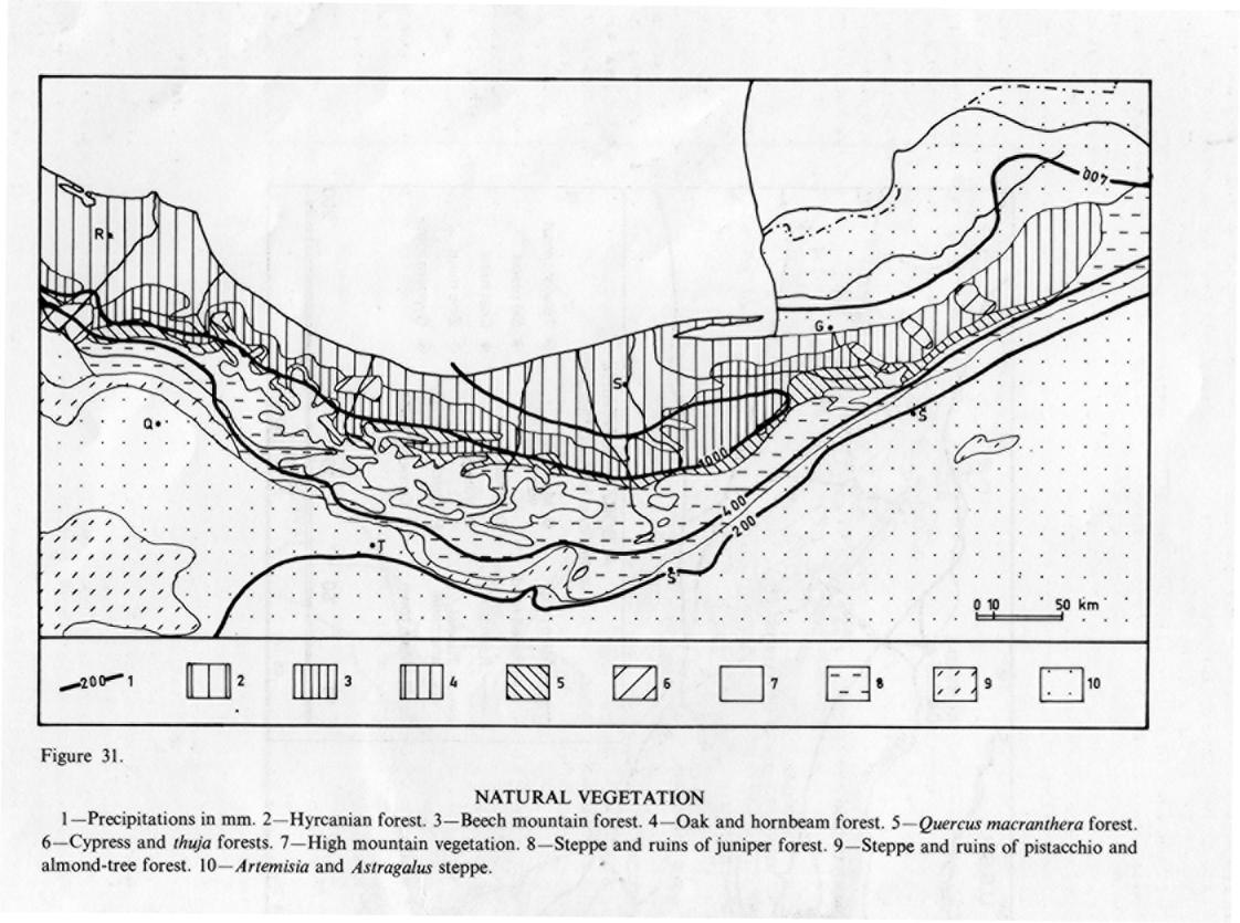
On the humid north slopes, numerous watercourses flow toward the Caspian in deeply cut valleys. Their banks, often quite steep, are covered with thick deciduous forests, thanks to the abundant precipitation and to the temperatures, which are high in summer and relatively mild in winter. The vegetation (Figure 31) encompasses the following levels (Bobek, “Die natürlichen Wälder und Gehölzfluren Irans,” Bonner geographische Abhandlungen 8, 1951, pp. 16-21; M. Zohary, “On the Geobotanical Structure of Iran,” Bulletin of the Research Council of Israel, Section D, II, 1963, p. 28; S. Mobayen and V. Tregubov, Guide pour la carte de la végétation naturelle de l’Iran, UNDP/FAO IRA7, Bulletin 14, Tehran, 1970): 1. The “Hyrcanian” forest of the lowlands also covers all the lower part of the mountains. This forest, a relic of the Tertiary, is remarkable for the density of its vegetation, arranged in superimposed layers and choked with climbing plants, and for the variety of its trees, including numerous indigenous species like Quercus castaneaefolia, Zelkova crenata, Parrotia persica, Pterocarya fraxinifolia, Gleditschia caspica, and Albizzia julibrissin. These species disappear one after the other at altitudes between 500 and 1,000 m. 2. The Caspian mountain forest, between 1,000 and 2,000-2,200 m, is dominated by the Oriental beech (Fagus orientalis), along with oaks, birches, alders, and maples (A. Mossadegh, “Aperçu sur les hêtraies montagnardes des forêts de la Caspienne en Iran,” Revue forestrière française I, 1968, pp. 20-25). 3. The subhumid forest of Quercus macranthera and Carpinus orientalis is low and discontinuous. It appears between 1,800 and 2,500 m, where the precipitation diminishes and the action of the wind and ice makes the growth of trees more difficult, or on patches of particularly poor soil. 4. The alpine meadows consist mainly of herbaceous plants belonging to the Euro-Siberian flora but also, above 2,500 m, of xerophilous plants, including the spiny cushions of various species of Astragalus. The vegetal formations of the northern slopes present several variations reflecting local topographical, climatic, and soil conditions (W. Probst, “Vegetationsprofil des Elburzgebirges (Nordiran),” Botanische Jahrbuch 91, 1971, pp. 496-520; idem, “Beobachtungen zum Standortklima in verschiedenen Vegetationszonen des Elburzgebirges (Nordiran),” ibid., 94, 1974, pp. 65-95); e.g., the stands of mountain beeches are replaced by a forest of oaks and birches as the precipitation declines to the east of Gorgān. The only important colonies of conifers, remnants of a vegetation of the Mediterranean type, are found in the dryer zones: cypress forests (Cupressus sempervirens, var. horizontalis) in some parts of the sheltered valleys (the Sefīd-rūd between Manǰīl and Rūdbār, Čālūs around Ḥasanābād) and a forest of Thuja orientalis east of Gorgān (M. H. Djazirei, “Contribution à l’étude des forêts primaires de la Caspienne,” Bulletin de l’Institut Agronomique Gembloux33/1, 1965, pp. 35-75).
The many forests of the northern slopes contrast sharply with the monotonous steppes that cover the subarid southern slopes, where, below 3,000 m, the dominant vegetation is composed principally of Artemisia and Astragalus, with thickets of trees in the ravines near the springs. This steppe, which is original on the whole central plateau, seems, to judge from the accounts of travelers of the past and of several pockets of residual population, to have replaced a formation of bushes and shrubs consisting of pistachio trees (Pistaia mutica) and hawthorn (Crataegus) that covered the arid lower slopes between 1,300 and 1,800 m (Bobek, “Die natürlichen Wälder,” pp. 21-24) and a light forest of junipers (Juniperus excelsa) between 1,800 and 3,000 m; the latter still survives in the region of Fīrūz Kūh and the Šāh Kūh. The grazing of flocks and the manufacture of wood charcoal have destroyed the dry southern forests and heavily depleted the humid forests of the Caspian slopes (X. de Planhol, “Le déboisement de l’Iran,” Annales de géographie 430, 1969, pp. 25-35). After 1967 a law for the protection and exploitation of grazing lands and forests tended to slow the desertification of the arid slopes, where intense erosion, especially owing to summer floods, is rapidly filling in the barrier lakes formed by recently constructed dams.
Population and economic life. Settlement of the Alborz goes back to ancient times, as several discoveries of prehistoric tombs suggest (J. de Morgan, Mission scientifique en Perse IV, Paris, 1896); Zoroastrian remains from the Sasanian epoch are also numerous in these provinces, which were among the last to be converted to Islam. The peoples of the Alborz have always been at the center of national resistance: against the ʿAbbasid caliphate when the Buyids, originating from Daylam (in the western Alborz), assumed the real power in Baghdad in 334/945 (V. Minorsky, “La domination des Dailamites,” Iranica, University of Tehran 175, Tehran, 1964, pp. 12-30) and ensured the Iranian political renaissance, and against the Turkish-speaking nomads after the 5th/11th century, owing in particular to the Ismaʿili kingdom of Alamūt, whose castles, from Rūdbār to Dāmḡān, held our for a long time against the Mongols in the 7th/13th century. The Alborz forms part of those humid and populous mountainous fringes of the Near East that have constituted strongholds of stable sedentary life, in sharp contrast to the dry plains, which have always been menaced by instability and nomadic invasions, and to the dryer mountains like the Zagros or the “bedouinized” Taurus of the Middle Ages (de Planhol, Recherches sur la géographie humaine de l’Iran septentrional, Mémoires et documents, CNRS 11/4, Paris, 1964, p. 36). Despite a relatively dense population, which is experiencing sizable natural increase and intense emigration simultaneously, there is no urban center in the Alborz, aside from small towns like Fīrūz Kūh or Damāvand.
Linguistically the populations of the Alborz form part of the north Iranian group. The Persian language, which predominates on the central plateau east of Qazvīn, has only slightly penetrated the mountain zones, where two main language groups can be distinguished (B. Hourcade, “Le processus de la déprise rurale dans l’Elbourz de Téhéran [Iran],” Revue de géographie alpine 64/3, 1976, pp. 365-88). In the north and in the high valleys of the southern slope, languages of the Gīlakī and Māzandarānī type predominate, whereas farther south, in a broad zone that often encompasses the piedmont (Šemīrān, Semnān), dialects of the “Tātī,” “Fārsī Māzandarānī,” or “Semnānī” type are spoken. The sedentary nuclei of Gīlakīs or Māzandarānīs who have resisted the nomads and repopulated the whole range from the north slopes are numerous in the subarid central and western Alborz (Alamūt, Ṭālaqān, the Jāǰ-rūd valley, Lārīǰān, Fīrūz Kūh, Nūr) and in the basins at medium altitudes near the Caspian forest (Daylamān, Eškavar, Kalārdašt; de Planhol, Recherches, p. 37). This ethnic base of Caspian type was complicated by the addition, from the 11th/17th century on, of isolated groups of Turks (Alamūt, Rūdehen, Damāvand, Fīrūz Kūh) and Kurds (Rūdbār, Kalārdašt, the Qazvīn piedmont, Damāvand) and especially by the summertime presence in the mountains (yeylāq) of a great many seminomadic tribes speaking quite different languages. These nomads winter in the piedmont (qešlāq), especially between Tehran and Semnān, and often settle on the first foothills of the chain (Anti-Alborz). The most numerous are the Hedāvand (Lorī), the Kōtī (Arabic speakers), the Alī Kāy (Gīlakī), the Oṣānlū (Turks), the ʿArab (Persians), and above all the Sangsarī (de Planhol, Recherches, p. 34; Hourcade, “Les nomades du Lâr face aux problèmes de l’expansion de Téhéran,” Revue géographique de l’Est 17, 1977, pp. 37-51). Originating in the small city of Sangsar near Semnān, this last group of fairly prosperous seminomads dominates the entire pastoral life of the central and eastern Alborz; their flocks graze in winter on the northern margins of the Dašt-e Kavīr (regions of Qom and especially of Šāh-rūd and Sabzevār), and they thus perform some of the longest migrations known. In the western Alborz, the nomads have not sought summer pasture for several decades; in contrast, the flocks of the villagers (Alamūt, Ṭālaqān) are particularly numerous on the Qazvīn piedmont in the spring. On the northern slopes of the chain seminomads are rarer. The Gāleš, who graze their fat-tailed flocks in the forest of the lower slopes prefer the yeylāq of the Gīlān mountains; several small groups of farmers from the plain also seek summer pasture (for example, Zelī from the Āmol region, on the northern slope of Damāvand).
Population migrations are and have been intense in the whole Alborz region; numerous remains of caravansaries attest to their use by villagers, who used to go by mule from valley to valley or from one slope to the other to exchange produce or to work. In the many high mountain villages of the arid slope the men used to leave in winter to work in the forests or rice fields of the Caspian provinces, where the same language is spoken. These large seasonal, climatic, commercial, or labor migrations have been noted by travelers since the 19th century, particularly in Lārīǰān (Aucher-Eloy, Relations de voyage en Orient de 1830 à 1838, Paris, 1843, p. 448). Since World War II (de Planhol, Recherches, p. 28), these cyclical migrations to the north have been gradually replaced by progressively more permanent labor migrations to the Tehran piedmont, which the mountain people had seldom frequented until then (Hourcade, “Le processus,” p. 369). The temporary and then permanent abandonment of the villages, which are presently losing a large part of their young people, is the culmination of an evolution marked first by the multiplication of agricultural or pastoral establishments at high altitudes in response to the growing disequilibrium between demographic pressures and available resources. The forest villages of the northern slope were affected later; at first, they supplemented their resources through unbridled exploitation of the forests in order to furnish Tehran with wood charcoal. The apogee of rural life in these northern regions occurred about 1950-60 (de Planhol, Recherches, p. 58).
The rural economy is tied to that of both the northern and southern foothills (E. Ehlers, “Anbausysteme in den Höhenregionen des Mittleren Elburz, Iran,” Erdwissenschaftliche Forschung V, Vergleichende Kulturgeographie des Hochgebirge des südlichen Asien, Wiesbaden, 1973, pp. 62-75). The villages midway up the Caspian slopes practice rainfall cultivation of grains; they rotate crops on terraces dotted with the silhouettes of the kūppā, platforms where the wheat sheaves are put to dry before threshing (de Planhol, 1964). The larger livestock, stabled in winter, are led in summer to a nearby yeylāq in the upper part of the forest, then onto the fields after harvesting. The smaller animals, in vast flocks, climb in summer to the unsheltered pastures of the upper altitudes and descend in winter to the low wooded hills just above the rice-growing plains. In the villages of the northern slopes the rural economy is based on a combination of tiny irrigated land holdings (sometimes arranged in terraces) devoted to grains, fodder, and vegetables with precarious rotating rainfed crops and the raising of small dairy animals. In winter these animals are fed in stables (often in caves) and are included less and less in the inverse transhumance on the qešlāq of the dry piedmont; in summer the animals graze on a high yeylāq, where the systems of supervision, of the “little mountain” type, are gradually being replaced with many types tending toward hired herdsmen (Hourcade, “Le processus,” 1976). Because of the development of Tehran, the past twenty years have witnessed an expansion in the raising of dairy cattle and of small animals for meat. Traditional pastoralism, along with grain farming, is disappearing rapidly, while in its place there is emerging a new rural landscape based on cultivation of fruit trees (apples and cherries on the slopes, apricots lower down, and pomegranates near the piedmont), which is sometimes the only crop in certain valleys of the central Alborz (Karaǰ, Jāǰ-rūd). In the eastern Alborz, farther from the direct influence of the capital, the traditional systems are better preserved.
Traditional rural handicraft was primarily utilitarian and often unskilled (felts [namad] on the Caspian slopes, gelīms at Alamūt, coarse textiles called karbās and implements almost everywhere). The weaving of carpets, which was very little known until recently (Ṭālaqān), has been undergoing a fairly rapid development since 1965-1970 because of the decline of other agricultural and pastoral activities and owing to the techniques taught by the nomads (Sangsarī) and to a lesser extent by the merchants of Tehran, Qom, or Qazvīn. The compact rural settlement is often composed of two-story houses (Caspian influence) with flat roofs; the use of wood for construction is widespread except in the villages at high altitudes and in the piedmont, where the houses are often single-storied.
The mineral resources of the Alborz are varied but not abundant. The Jurassic coal mines of Šemšak and Gāǰera, well equipped from 1935 on, have been closed since 1977. The output (less than 100,000 tons) destined for the industries of Tehran is presently extracted from a multitude of tiny, often privately managed mines and from several more important centers directly exploited by the state: Sang-rūd in Gīlān, several regions of Šāh-rūd (Deh Mollā), and above all the central Alborz (Lālān and Garmābdar in the Jāǰ-rūd valley, Elīka in the Čālūs valley, and Zīrāb and Galand-rūd in the Māzandarān plain). Several mines are being exploited for metallic minerals in modern fashion, including those of Dūnā (Čālūs valley) for lead and zinc and that of Nōbarān (Karaǰ) for barite. By contrast, centers of extraction for construction materials are very important: limestone for the cement factories of the Tehran region (Ābyek, Rey, Bāḡ-e Komeš) or Lowšān; chalk for the lime kilns of Nesā (Karaǰ); and above all gypsum. The gypsum formations (Āzādbar, Nīknām Deh) are of international significance, and the output is processed principally in the great plaster factory near the Latīān dam.
The exploitation of the mines has accelerated the construction of roads in the whole Alborz chain. Traveling is nevertheless difficult because of the altitude, the steepness of the slopes, the snow, and the narrowness of the valleys. Until the reign of Reżā Shah,
only mule caravans crossed the mountains, carrying wheat, salt, and dried fruits from the Iranian plateau toward the Caspian and rice, gasoline, and wood charcoal in the reverse direction. Three main routes traverse the central Alborz. The oldest goes through Fīrūz Kūh and the Gadūk pass, also used for the trans-Iranian railroad, which crosses through a tunnel at an altitude of 2,028 m before descending toward Šāhī by means of numerous bridges and tunnels. From Garmsār this rail route follows the old line of the “Caspian pylons” along the Ḥabla-rūd valley. The most traveled route between Tehran and the Caspian passes through the Karaǰ and Čālūs valleys and the Kandovān pass (2,570 m). The valley route from Harāz and the Emāmzāda Hāšem pass (2,750 m), built after World War II, is often impassable in winter, when the only viable route is the one that crosses the extreme western end of the chain, by the Sefīd-rūd corridor between Manǰīl and Rašt. In the eastern Alborz several secondary routes cross the chain north of Semnān and Šāh-rūd. Since the late 1960s thanks to a multitude of new roads and tracks, many villages have broken out of their isolation and experienced a radical disruption of their existence.
Whereas the eastern Alborz still remains free of brutal contemporary transformations, the western part of the chain feels the influence of Rašt and especially of Qazvīn, and the central Alborz is undergoing a profound mutation resulting from the overwhelming impact of the Tehran-Karaǰ agglomeration. The dams of Amir Kabīr (Karaǰ, capacity 205 million cu m, finished in 1961) and Faraḥnāz (Latīān on the Jāǰ-rūd, capacity 80 million cu m, finished in 1967) furnish the capital with water and to a small degree with electricity. Since 1983 the great Lār dam (960 million cu m) has diverted a great part of the waters of the Rūd-e Harāz toward Tehran and the Varāmīn plain. The subsidiary Ṭālaqān dam, thanks to a tunnel 11 km long, diverts part of the Šāh-rūd waters toward the agricultural piedmont around Qazvīn. These dams have modified the economy of the region, more through tight restrictions on livestock farming in order to limit overgrazing and erosion than through inundation of land or the development of tourism that they make possible. Summer tourism, once practiced only by the court, is now a mass phenomenon, which affects nearly all levels of society. It is essentially weekend tourism confined to the Karaǰ, Jāǰ-rūd, and Damāvand valleys but spreading by degrees into the neighboring valleys (Ṭālaqān, Nūr, Kalārdašt, Koǰūr) through construction of second homes. Few resorts are equipped for summer (Āb-e ʿAlī, Rūdbārak), but for winter sports there are several medium-sized resorts (Šemšak, Dīzīn, and Towčāl). The central Alborz has become the Tehran Alborz, an area of leisure for the capital’s inhabitants.
See also Anti-Alborz.
Bibliography:
See also Geology: P. Allenbach, Geologie und Petrographie des Damavand und seiner Umgebung, Zurich, 1966.
R. N. Annells et al., Explanatory Text of the Qazvin and Rasht Quadrangle Maps, Geological Survey of Iran, Tehran, 1975.
R. Assereto, Explanatory Notes on the Geological Map of upper Djadjerud and Lâr valleys, Milan, 1966.
E. B. Bailey et al., “Notes on the Geology of the Elburz Mountains, North-East of Tehran, Iran,” Quarterly Journal of the Geological Society of London 104, 1948, pp. 1-42.
E. G. Cartier, Die Geologie des mittleren Chalus Tales, Zentral Alborz, Zurich, 1971.
E. Dedual, Zur Geologie des mittleren und unteren Karaj Tales, Zentral Elburs, Zurich, 1967.
J. Dellenbach, Contribution à l’étude géologique de la région située à l’est de Téhéran, thesis, Strasbourg, 1966.
A. Gansser and H. Huber, “Geological Observations in the Central Elburz,” Schweizer Mineralogische Petrographische Mitteilungen 42, 1962, pp. 583-630.
M. Glaus, Die Geologie des Gebietes nördlich des Kandevan-passes, Berne, 1970.
C. Lorenz, Die Geologie des oberen Karaj Tales, Zurich, 1966.
S. P. Meyer, Die Geologie des Gebietes Velian-Kechire, Zurich, 1967.
N. Sieber, Zur Geologie des Gebietes südlich des Teleghan-Tales, Zentral Elburs, Berne, 1970.
P. Stalder, “Magmatisme tertiaire et subrécent entre Taleqan et Alamut, Elbourz central (Iran),” Schweizer Mineralogische Petrographische Mitteilungen 51, 1971, pp. 2-138.
R. Steitger, Die Geologie des West Firuzkuh-area, Zurich, 1966.
P. E. Süssli, The Geology of the Lower Haraz Valley, Central Alborz, Iran, Geological Survey of Iran, Tehran, 1976.
A. Vatan and I. Yassini, “Les grandes lignes de la géologie de l’Elbourz central dans la région de Téhéran et de la plaine caspienne,” Revue de l’Institut Français du Pétrole24/7-9, pp. 846-78, 973-1006.
Geomorphology: H. Bobek, “Zur Eiszeitlischen Vergletscherung des Alburzgebirges, Nordiran,” Carinthia 142/2, 1953, pp. 97-104.
Idem, “Die Takht-e-Sulaimangruppe im mittleren Alburzgebirge, Nordiran,” Festschrift zur Hundertjahrfeier der Geographischen Gesellschaft in Wien, Vienna, 1957, pp. 236-64.
P. Bout et al., Observations de géographie physique en Iran septentrional, Mémoires et Documents CNRS 8, Paris, 1961.
Climate and vegetation: P. Beaumont, “A Climatological Traverse from the Caspian Sea to the Watershed of the Elburz Mountains,” Weather 23, 1968.
E. Ehlers, “Das Chalus-Tal und seine Terrassen. Studien zur Landschaftgliederung und Landschaftgeschichte des mittleren Elburz (Nordiran),” Erdkunde 23, 1969, pp. 215-99.
A Gilli, “Die Pflanzengesellschaften der Hochregion des Elburzgebirges in Nordiran,” Beihefte Botanischer Zentralblatt 59/B, 1939, pp. 317-44.
R. Hedjazi and H. Sabeti, Guide to the Natural Vegetation of Elburz (Karaj-Tchalus Profile), University of Tehran Agricultural Bulletin 26, Karaǰ, 1961.
H. Melchior, “Zur Pflanzengeographie des Elburz-Gebirges in Nordiran,” Sitzungsberichte der Gesellschaft Naturforschender Freunde Berlin 1937, Berlin, 1938, pp. 55-71.
Travelers: V. Baker, Clouds in the East: Travels and Adventures on the Perso-Turcoman Frontier, London, 1876.
F. Clapp, “Tehran and the Elbourz,” Geographical Review 20, 1930, pp. 69-85.
G. von Call-Rosenburg, “Das Larthal bei Tehran und der Demavand,” Mitteilungen der Kaiserlichen Königlichen Geographischen Gesellschaft, 1876, pp. 114-42.
L. S. Fortescue, “The Western Elburz and Persian Azerbaidjan,” Geographical Journal63, 1924, pp. 301-18.
S. Hedin, Eine Routeaufname durch Ostpersien, 2 vols., Stockholm, 1906-18. A. Houtum-Schindler, Eastern Persian Irak, London, 1896.
B. Lowett, “Itinerary Notes of Route Surveys in Northern Persia in 1881 and 1882,” Proceedings of the Royal Geographical Society 5, 1883, pp. 58-84.
Th. Kotschy, “Der westliche Elburs bei Tehran,” Mitteilungen der Kaiserlichen Geographischen Gesellschaft, 1881, pp. 65-110.
J. B. Noel, “A Reconnaissance in the Caspian Provinces,” Geographical Journal 57, 1921, pp. 401-18.
H. L. Rabino, “Les provinces caspiennes de la Perse, le Guilân,” RMM 20, 1917, pp. 1-499.
A. F. Stahl, “Reisen im Nord und Zentral Persien,” Petermans geographische Mitteilungen 118, 1895.
Idem, “Teheran und Umgebung,” ibid., 46, 1900, pp. 49-57.
Idem, “Reisen im Nord und Westpersien,” ibid., 53, pp. 121-32.
H. L. Wells, “From Tehran to the Caspian Sea,” Geographical Journal, 1896, pp. 501-13.
Human and economic life: M. Bazin, Ch. Bromberger (with A. Askari, and A. Karimi), Gilân et Âzarbâyjân oriental: Cartes et documents ethnographiques, Bibliothèque iranienne 24, Paris, 1982.
B. Hourcade, “Migrations de travail et migrations de loisir dans l’Elbourz de Téhéran,” Revue de Géographie de Lyon 3, 1978, pp. 229-240.
Idem, “L’Anti-Albourz, un escape marginal aux ports de Téhéran,” Revue Géographique de l’Est, 1982, 1-2, pp. 61-97.
X. de Planhol, “Elbourz et chaînes pontiques: deux franges montagneuses du Proche-Orient,” Acta geographica, 1968, pp. 11-13.
See also G. Stampfli et al., “Le dévonien de l’Elbourz Oriental: statigraphie, paléontologie (Brachiopodes et Bryozoaires), paléogéographie,” Rivista italiana di paleontologia e stratigrafia 84, 1978, pp. 1-46, pls. 1-5.
Idem, “Géologie et micropaléontologie (nummulites et palynologie) de la formation éocène de Ziarat, Elbourz Oriental (Iran),” ibid., pp. 383-402, pls. 31-32.
(M. Bazin, E. Ehlers, B. Hourcade)
Originally Published: December 15, 1985
Last Updated: July 29, 2011
This article is available in print.
Vol. I, Fasc. 8, pp. 813-821
M. Bazin, E. Ehlers, B. Hourcade, “ALBORZ iii. Geography,” Encyclopædia Iranica, I/8, pp. 813-821; an updated version is available online at http://www.iranicaonline.org/articles/alborz-geography (accessed on 17 May 2014).